Protect the Adirondacks is pushing for an amendment to the Adirondack Park Agency (APA) Act to preserve the ecological integrity, wildlife and open space in the Adirondack Park. The bill would strengthen the Adirondack Park Land Use and Development Plan, originally adopted as part of the APA Act in 1973, by incorporating modern conservation design principles to curtail widely scattered exurban development, or “rural sprawl,” in the Adirondack Park. The APA Act has been largely unchanged since 1973.
Conservation science now recognizes that the spatial pattern of development is fully as ecologically important as its density. Rural sprawl impairs ecosystem function, decreases biotic integrity, alters species behavior and composition, increases human-wildlife conflicts, and undermines the open space character of the Adirondack Park. The greatest threat to the forest products industry in New York is fragmentation of the forest resource into smaller lots and subdivisions because smaller lots will not be actively managed for commercial logging.
This bill would require that these factors be identified and considered for major, large-scale residential subdivisions in Low Intensity, Rural Use and Resource Management areas. The importance of this bill cannot be overstated. It would provide the APA with scientific tools necessary to review and evaluate proposals for large-scale residential development in the most vulnerable areas of the Adirondack Park.
Assembly Conservation Committee Chairman Steven Englebright and Senate Conservation Chair Todd Kaminsky recently introduced a conservation design bill for the Adirondack Park to require conservation development to protect open space in the Adirondack Park. The bill would strengthen the APA Act by incorporating modern conservation design principles to curtail, and hopefully prevent, the sprawl pattern development often approved by the APA. This bill would require conservation design for large-scale subdivisions in areas classified as Low Intensity, Rural Use and Resource Management under the APA Act.
The importance of this bill cannot be overstated. It would provide the APA with scientific tools necessary to review and evaluate proposals for residential development in more vulnerable areas of the Park. “Rural sprawl” impairs forest ecosystems. The past president of the Empire State Forest Product Association stated that the greatest threat to the forest products industry in New York is fragmentation of the forest resource into smaller lots and subdivisions.
Fragmentation by of forest ecosystems by roads and houses create serious long-term negative impacts that degrade Adirondack forests. The long-term impacts from residential development go far beyond the walls of a house or the shoulders of a road. Numerous planners and scientists over the years have provided the APA with information about the impacts of sprawl pattern development on forest ecology, documenting the wide range of negative impacts that go well beyond the immediate house and road locations to degrade forest ecosystems. Scientists have developed and long utilized “ecological impact zone” analysis to gauge potential negative impacts from development.
Numerous planners and scientists over the years have documented the impacts of sprawl pattern development on forest ecology. The scientific community has shown the wide range of impacts that go well beyond the immediate house and road locations and have shown how forest ecology changes from fragmentation. Planners have long utilized to tool of “ecological impact zones” to gauge potential negative impacts from development.
The impacts of residential development in a forest ecosystem radiate out to a distance of 200 meters from developed areas around roads and houses to change the flora and fauna. The composition of bird species changes in this area. The composition of large and small mammals changes. The composition of plants and shrub species changes. These changes have long been documented in the scientific literature. The ecological impact zone of 200 meters in Adirondack forests captures these impacts.
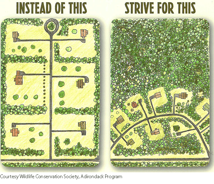
The best defense for forest ecosystems against the negative impacts of development is to cluster development and contain the negative impacts from construction of houses and roads and the inevitable loss of forests. By clustering development and large block of contiguous forest can be protected. Large blocks for open space and healthy forests is what defines the Adirondack Park landscape. To protect Adirondack forests into the future, we need new tools to protect open space. Conservation design is an important tool.
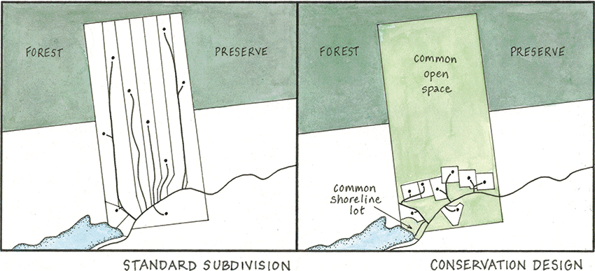
This schematic compares two approaches to the development of a forested tract in the Adirondacks. On the left is a standard subdivision that cuts up the lots equally and separates the house locations. This maximizes the impacts from roads and house. On the right in a conservation development model that clusters development, contains the impacts from roads and houses, and preserves a large area of contiguous forest.
Over the last 20 years, the APA has approved a number of large-scale development sprawl pattern developments that would have benefited from the use of conservation design. The APA has resisted changes to the APA Act to require conservation design, and makes the argument that sprawl pattern developments that spreads out roads and houses throughout a given tract is the best that the APA can do. The APA continues to argue that the sprawl pattern development approved in the 6,234-acre Adirondack Club & Resort project in Tupper Lake somehow preserved the open space forests resources on these lands.
Recently, the APA executive director made the statement that in the controversial ACR in Tupper Lake “more than 95% of the Resource Management lands were deed restricted in perpetuity against further development.” This statement is a distortion of reality about both the fate of Resource Management lands and the impacts to natural resources from the ACR development design as approved by the APA in 2011. The way that the APA arrived at the figure that 95% of the Resource Management lands in the ACR project are permanently protected in the future is to count only land that is underneath either an approved road, driveway, or building. The ACR project included 4,805 acres classified as Resource Management. The APA claims that only 240 (5%) acres would be impacted by development.
In the ACR project, the APA approved 706 buildings on 6,234 acres; 453 units in 125 townhouses; 206 single family dwellings; 39 “Great Camps;” and 8 other “cabins.” Over 25 miles of roads were also approved. A 200-meter ecological impact zone analysis found that 2,921 acres would experience long-term negative impacts from development, some 46.8% of the property, from road and building construction. See a map attached of an EIZ analysis of the ACR project.
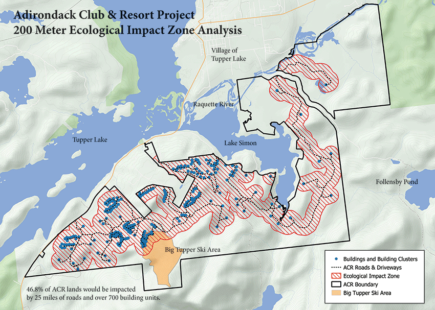
In the ACR project, the APA approved 706 buildings on 6,234 acres; 453 units in 125 townhouses; 206 single family dwellings; 39 “Great Camps;” and 8 other “cabins.” Over 25 miles of roads were also approved. A 200-meter ecological impact zone analysis found that 2,921 acres across the property would experience long-term negative impacts from development, some 46.8% of the property, from road and building construction. The map above shows the impacted areas.
The long-term negative impacts to Resource Management lands were also extensive. Under APA approval, the 4,805 acres of Resource Management lands would see 35 Great Camps and 45 single family residences. On the question of Resource Management lands, a 200-meter ecological impact zone analysis found that 1,803 acres would experience long-term negative impacts from development, some 37.5% of Resource Management lands, from road and building construction.
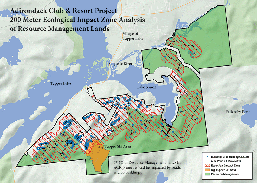
Under APA approval, the 4,805 acres of Resource Management lands would see 35 Great Camps and 45 single family residences. The map above shows a 200-meter ecological impact zone analysis of the Resource Management lands that found that 1,803 acres would experience long-term negative impacts from development, some 37.5% of Resource Management lands, from road and building construction.
Conservation development and design would have changed the ACR project is three critical ways. First, it would have required that a minimum of 75% of the Resource Management lands be permanently protected in a large contiguous block of open space. The current sprawl pattern design only protected less than 25% in the northeast corner of the tract (top right on map above) in a large block of open space. Second, conservation development would have significantly minimized road construction, which would have lessened negative impacts from development and costs for the developer. Third, the developer could have received a 20% density bonus by protecting 85% of the Resource Management lands in open space. The ACR project would have benefitted enormously from conservation development standards from the new proposed legislation.
After more than two years being vetted, the Englebright-Kaminsky conservation development legislation was modified in a number of critical ways to meet the concerns of local government leaders in the Adirondack Park. Incentives were added to maximize conservation benefits and a limited transferable development rights program was added, among other changes. These were longstanding objectives championed by local government leaders.
Protect the Adirondacks is working with many other organizations and interests to pass conservation development legislation in early 2020 to update the APA Act. This legislation is vital to protect the great open spaces and forests of the Adirondack Park and to ensure that the Adirondacks is a place where the highest quality subdivisions and developments are approved and undertaken.
The legislation would prevent another poor quality subdivision like the ACR project from being approved and developed in the Adirondacks. This legislation is an important new tool to protect the great open spaces of the Adirondack Park.


