One of the biggest experiments in the northeast U.S. in stormwater management is up and running at the south end of Lake George. Last June, Warren County completed a reconstruction project on a .75 mile stretch Beach Road utilizing a porous pavement system. The Beach Road runs from the Garrison bar and restaurant (sadly closed) along the south end of the lake to Canada Street in the Village of Lake George. This was a major upgrade of that road system, with a special effort to vastly improve stormwater management. It is hoped that this investment will provide some relief from the high pollution loading to the lake from the horseshoe of intensely developed areas in the Village and Town of Lake George and parts of Queensbury at the lake’s south end.
Enhanced stormwater management and control systems are badly needed if we are to stem the inexorable downward trend in water quality of Lake George. It’s long been understood that water quality at the south end of the lake is measurably different from water quality at the north end. The south end functions much as a mesotropic lake, one with medium range water quality, whereas the north end functions more like an oligotrophic lake, with some very high water quality. The “dead zone” at the south end of the lake is caused by high levels of nutrient and pollution loading the lake experiences from the Village and highly developed areas around the south end. It’s not that land use practices are demonstrably better at the lake’s north end, it’s just that acre for acre there’s a lot less intense land use; fewer houses, yards, hotels, buildings, parking lots, and far fewer roads and impervious areas.
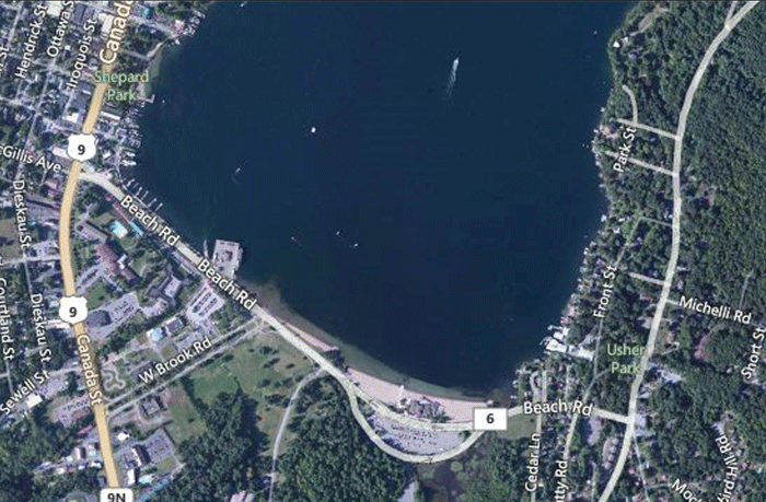
Map of the Beach Road area at the south end of Lake George. This area is the most intensely developed area around Lake George.
The chief problem facing Lake George, and many other lakes and ponds throughout the Adirondack Park, is stormwater pollution from a variety of residential, commercial and municipal sources. Across the Adirondacks many communities developed along the shores of lakes and ponds, as these were the historic transportation corridors. Roads often followed rivers through valleys. In recent decades lakeshores have seen steadily more intensifying development with ever larger homes, extensive driveways and secondary buildings, expansive green lawns highly maintained with fertilizers and pesticides, and all done with often completely inadequate stormwater controls.
Today, the intensity of development on the shores and uplands of many of the Adirondack Park’s biggest and grandest lakes is causing a slow, steady decline in water quality. Reversing this downward trend is a major challenge for those who look at what stewardship of our natural resources of the Adirondacks really means or look at what making this place some kind of model of sustainability really means.
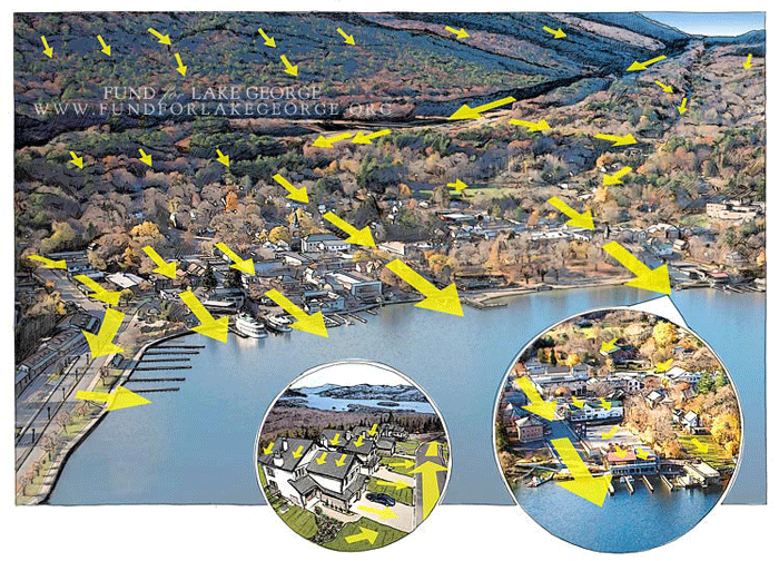
Where stormwater comes from. Courtesy of the FUND for Lake George: Do-It-Yourself Water Quality a Landowner’s Guide to Water Quality that Protects Lake George.
In addition to residential and commercial structures, local roads also generate a lot of stormwater during rainstorms. Much of the stormwater generated from roads flows directly into streams or a lake, often by design. For a highway engineer the top concern is getting water off of roads as quickly as possible when it rains for public safety; where it goes is a lesser concern. Stormwater carries with it high volumes of nutrients, such as phosphorus and nitrogen, as well as pollutants and chlorides, among other things. Nutrients stimulate higher levels of algal and plant growth in a lake, which reduces water clarity and increases chlorophyll rates. Constant loading at high levels changes water quality over decades. The larger the volume of stormwater, the greater the velocity. The greater the velocity, the more material stormwater picks up and carries with it, which is eventually dumped into a stream, lake or pond.
Prior to the new porous pavement system on Beach Road, its stormwater system featured rapid collection and straight piping of stormwater into Lake George. Actual stormwater management requires that stormwater be captured and infiltrated at a point away from streams and lakes. Infiltration of stormwater through the soils breaks down and suspends pollutants and nutrients.
There are many many proven ways to effectively manage stormwater. The science and engineering for stormwater management is voluminous and advanced and successful when utilized. Shoreline and stream buffers are highly effective. So are rain gardens, grassy trenches and swales as well as dry wells. Low Impact Development focus on range of practices such as minimizing site disturbance so that natural areas that capture and infiltrate stormwater are retained and not bulldozed and graded flat.
The goal of every residential and commercial property should be to function as a stormwater neutral site that exports zero stormwater off premises.
As a society, we know how to manage stormwater. The problem is, generally, we simply choose not to invest in stormwater management. It’s far easier to pollute than figure out how not to pollute.
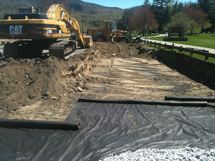
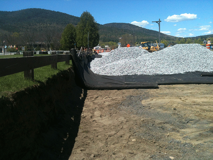
The use of porous pavement to capture and infiltrate stormwater is one of many control options. Here’s how it works on the Beach Road. The entire roadway was dug up. In some places the road grade was raised a few inches, but a 3.5 – 4 foot trench was dug out. Filter fabric was laid down on the bottom and along the sides of this trench. This allows water to pass through, but not sediment. 3 – 3.5 feet of 100% fractured stone was used as the base. Fractured stone, as opposed to rounded crushed stone, “locks” together to both support heavy loads above as well as maintain air space that water can seep through. The stone was prewashed.
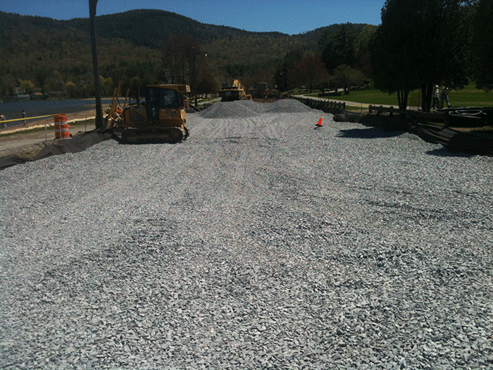
The trench was filled with 3 – 3.5 feet of fractured rock to form the base for the porous pavement system.
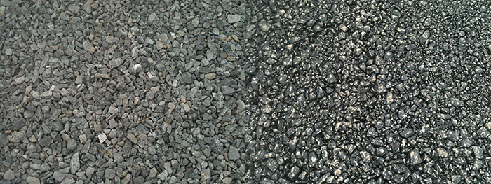
After the fractured rock was compacted, two layers of porous pavement were constructed. The bottom layer is a 9-inch course made up of fractured stone ranging from .375 – 2 inches inches in size. These rocks are held together by binder modified with polymers and mineral fiber strands. The air pockets in this course are around 22% of the total space, which allows for the seeping of stormwater. The top road surface layer is three inches of bounded smaller fractured stone .0625 – 1 inch in size. This provides a smoother driving surface, but retains an open air (“void spaces”) capacity of 18% that allows water to filter through. The porous pavement basically resembles a really big and thick Rice Krispy treat.
Several times this summer with friends or to show the project to visiting student groups I’ve dumped a 5 gallon bucket of lake water onto Beach Road and it’s a pleasure to watch it seep though the road in 15 seconds or so. 100% of the rain that lands on Beach Road will now be controlled. No more puddling, no more straight piping of stormwater into Lake George.
After water filters through the top 12 inch courses of porous pavement, the water trickles through the 3 – 3.5 foot fractured rock base, which provides “storage capacity” that can hold large volumes of water as it filters more slowly into the sand beds and groundwater. Engineers estimate that this system can handle total volumes generated by a 4 inch storm over a 24 hour period. With even minimal infiltration to the groundwater during this time the system could handle 5 inches or more.
It should also be noted that the water table in this area is high. The Beach Road area was once mostly part of the lake and the south end was dominated by wetlands. (The locations of the original Fort William Henry and then Fort George were selected because they were high spots with a good positions to see the lake as well as surrounded by wetlands, which provided good defenses.) In the base layers of the porous pavement system, water will at times rise from below into the fractured rock. The system was designed to handle this. In fact, the groundwater will moderate air temperatures in the fractured rock beneath the road to prevent any freezing and thawing cycles for the porous pavement layers. This system should function year-round without difficulty.
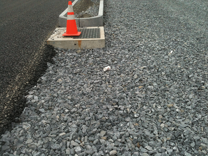
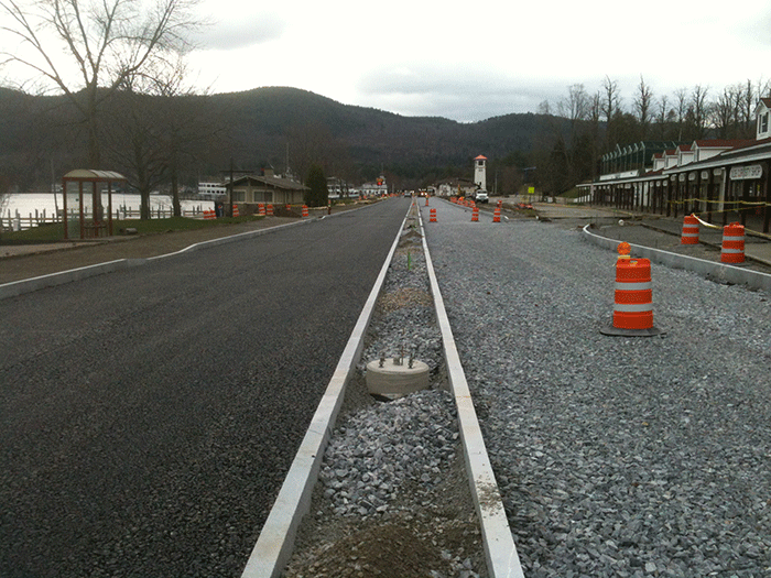
Beach Road construction: one lane has porous pavement completed (left), the other has the fractured stone base (right).
It should be pointed out that a Tropical Storm Irene type of event that dumps more than 7 inches of rain could inundate the system. In such cases, which are albeit rare, but becoming more common, stormwater will be discharged from the fractured rock base into Lake George using the old straight pipe system where 5-inch weirs were installed in the pipes where they meet the fractured rock. The weirs plug the pipe and prevent export of water during typical use, but allow for emergency overflow for massive storms. Not much can be done for stormwater management at times of a 7 inch storm.
There are many questions about how this system will operate over time and what the maintenance requirements will be. Because it’s a porous pavement system, the frost heaving that creates potholes should not occur, so this type of repair and maintenance likely will not be required. No sand will be used on the road system. The University of New Hampshire Stormwater Center found that far less salt is needed for a porous pavement system than a regular system. Tom Baird, senior managing engineer at Barton and Loguidice, who had the lead in designing this system in collaboration with Warren County and state officials, calculates that 11,000-12,000 less pounds of salt will be applied to Beach Road each winter than past practices and no sand. Importantly, because any daytime thawing of ice or snow on the road surface will filter through the porous pavement, the system will not see development of black ice. Beach Road will need to be vacuumed three times a year to clean out debris that could clog passages. This is a new and different maintenance regime. The Warren County DPW is working on plans to organize this work.
The porous pavement system will be studied for seven years to monitor both the functionality of the pavement durability of the road system and also pollution loading and water quality benefits. This will be important to assess how widely such systems can be used across the Park. The total cost of the Beach Road reconstruction was $7 million. The use of porous pavement added 15% to the costs. Porous pavement was not used everywhere on Beach Road. The Garrison hill leading to the Route 9L intersection was too steep for a porous pavement system. Also, the intersection with West Brook Road used standard impervious pavement because that area contains a large culvert below grade and water filtering onto the culvert would have degraded the system over time.
The Department of Environmental Conservation (DEC) operates the Million Dollar Beach complex, which is an Intensive Use area of the Forest Preserve, and owns the section of the Beach Road that passes through it. The DEC recently completed massive plans for a total upgrade of its facilities. The large parking lot will be raised and reconfigured with a porous pavement system. The southern lane of Beach Road will become a route for 2-way traffic road and built with porous pavement. The northern lane will be closed and reconstructed as part of the new parking lot. The west end of Million Dollar Beach will also become a new multi-season boat launch. This project will begin in 2014.
This experiment was a long time in coming. It took education of the Warren County DPW and project engineers. Then it took funding from the NYS Environmental Facilities Corporation, NYS Department of Transportation and federal government to augment county funds. All entities had various design approvals. The Warren County Soil and Water Conservation District pioneered the utility of the system basing the concept on .35-mile test strip at the entrance to the Maine Mall in Portland, Maine. In many ways this marked a step change for the Warren County DPW. At one time, innovative stormwater management was seen as something too far beyond its normal tasks of “plowing, mowing and paving.” Much has changed and Jeff Tennyson, the new head of the DPW, deserves big cheers for making this all happen. Many others at state and local agencies and organizations – too many to list here – also helped in this effort.
This is the type of practical water quality protection solution that should be widely replicated across the Adirondacks. The recent Adirondack Watersheds Institute study on chloride and sodium levels in the Adirondacks shows the high level of stormwater reaching our lakes and ponds. Salt is not produced around our lakes, but has to be carried to lakes via stormwater or leached from soils where it builds up.
Stormwater management is a key challenge for the Adirondack Park in the years ahead. Unfortunately, the APA Act is frozen in time in 1973 and doesn’t even include the word “stormwater” in its laws and its leaders have remained stonily passive in the face of water quality decline.
The maintenance of high water quality is in the interests of everyone who is concerned about the Adirondack Park. High water quality is directly linked to high property values and high tourism rates. For many, it’s the lakes and ponds and rivers of the Adirondacks that define their experiences here and underwrite the area’s high quality of life and high recreational opportunities.
The great hedge that has protected water quality for decades is that the majority of the watersheds of most Adirondack lakes are lands protected in the Forest Preserve. Natural forests are the best filters to capture and infiltrate rainfall and prevent the formation of stormwater. But human impacts from residential, commercial and municipal roads have an outsized impact on fragile freshwater ecosystems. The Lake George watershed is 48% Forest Preserve and over 90% forested, yet the lake is experiencing declining water quality.
The story is the same across much of the Adirondack Park. Now is the time to get serious about water quality protection. This is an economic as well as environmental investment. It’s what we need to do to meet any basic test of stewardship or sustainability. It requires changes to business as usual for land use and development as well as the construction and reconstruction of municipal infrastructure.
The Beach Road porous pavement project is an excellent model and shows what’s possible.

