These new hiking trail designs have vastly improved the state of the art for building sustainable and safe trails in Wilderness areas. New sustainable trails also harmonize wilderness values with popular hiking trails that see high levels of public recreational use.
By the metric of public use the High Peaks Wilderness Area, and nearby Giant, Hurricane and Sentinel Range Wilderness areas, are major successes. The crowds hiking in the High Peaks are at an all time high. The current dismal state of many of the hiking trails does not seem to be a major deterrent to the throngs of people eager to hike one of the High Peaks. For many people hiking a mountain like a High Peak is no sure thing and is, and should be, a challenge. There are plenty of highly used and popular smaller mountains throughout the Adirondacks that provide stunning views, but the allure of hiking a High Peak is immense. For many the view from a High Peak summit and one’s sense of personal accomplishment, however measured, erases their slog over long sections of eroded trails that damage the natural resources of these mountains. We need to change this equation so that people can continue to enjoy the High Peaks, push themselves to hike big mountains, create lifelong memories with friends and family, and do all this while hiking over beautiful and sustainable trails that protect the natural resources of this area and uphold Wilderness values.
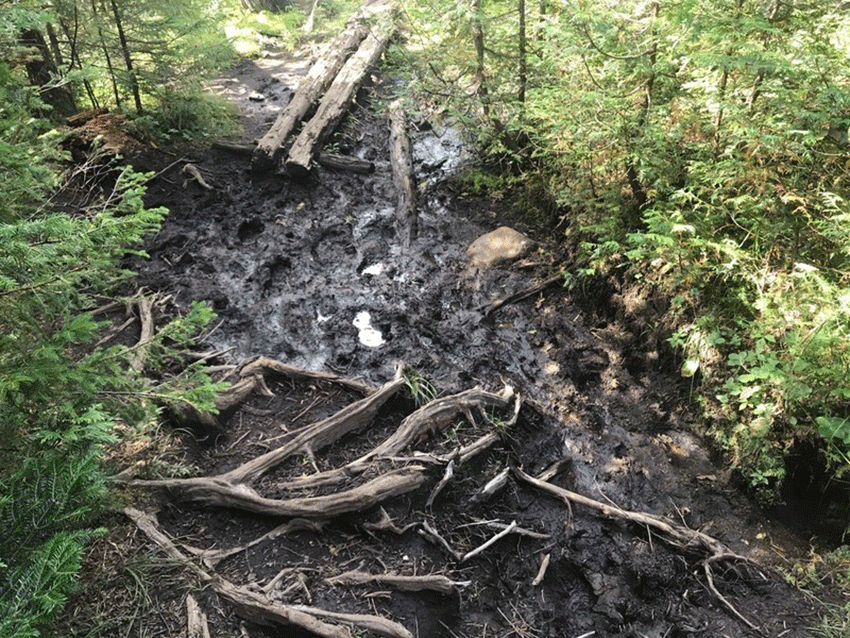
The hiking trails throughout the High Peaks and associated Wilderness areas are in disrepair. Throughout the High Peaks hiking trails generally run straight up the mountainside. Many of these trails were built, or stomped out, in the years after the Civil War in the late 1800s. Many of the “trailless” peaks in the High Peaks have no formal marked trails, but have a network of unmarked “herd paths” that are haphazardly maintained and often include a series of side trails and dead-end trails. Hiking trails in the High Peaks are often wide, eroded, degraded gashes on a mountainside that undermine the wilderness character and atmosphere of the area and negatively impact the area’s natural resources.
Over the last several years, Protect the Adirondacks has campaigned for greater resources to be invested by the State of New York in rebuilding the trails in the High Peaks Wilderness and we will continue to press for even greater investments in the years to come. Some progress is being made and in real ways and we’re seeing what the future could be in the new sustainable contour trails now under construction on Cascade Mountain and Mount Van Hoevenberg.
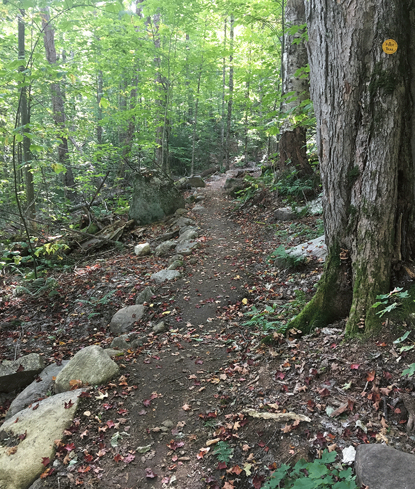
Typical scene of a highly eroded and degraded trail corridor in the High Peaks Wilderness. This picture shows a section of the trail up Mount Marcy. This is a trail that largely runs straight up the mountainside. This trail suffers from poor design as water runs into the trail center and erodes and degrades the trail.
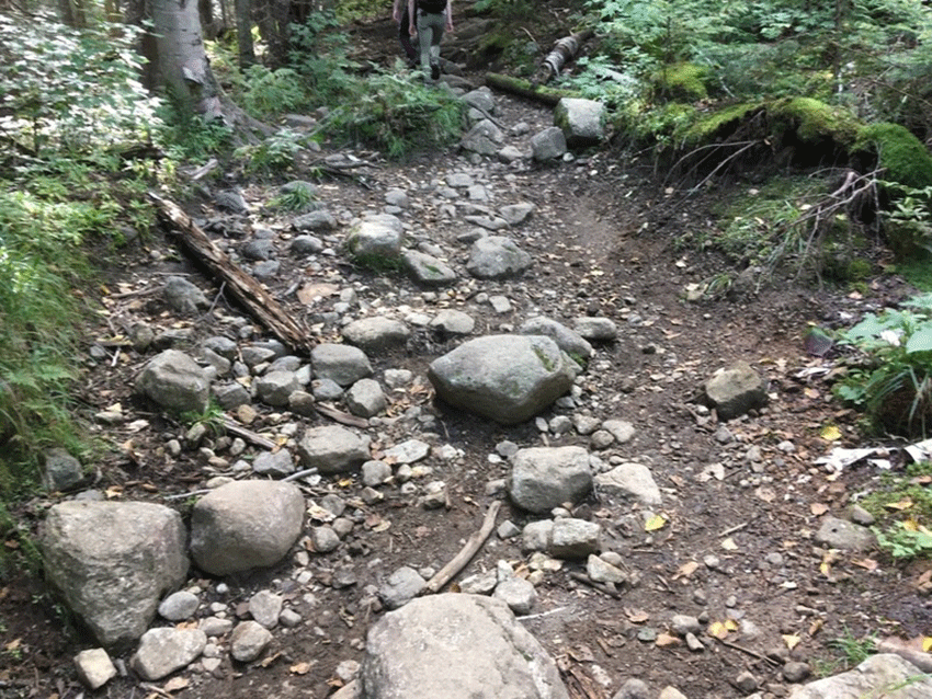
Another typical scene of a High Peaks trail. This is a section of trail on Algonquin Mountain. This trail is poorly designed and heavily worn.
Throughout the summer of 2019, three trail crews worked on the new hiking trails up Cascade Mountain and Mount Van Hoevenberg. This effort combined trail crews organized by the Department of Environmental Conservation (DEC), a trail crew from the Student Conservation Association (SCA) Adirondack program, and a private trail crew Tahawus Trails from the Hudson Valley. The SCA and Tahawus Trails both work under state contracts. The entire effort was managed and supervised by the DEC. Inmate laborers from the prison in Moriah also logged many hours working on these trails as did various volunteer efforts.
In many ways, the new hiking trails under construction on Cascade Mountain and Mount Van Hoevenberg are a showcase for new sustainable hiking trail design and construction methods. These trails are not only designed and constructed to withstand heavy use, but are designed and constructed to uphold Wilderness values.
These new hiking trails are narrow contour trails that traverse a mountainside on a course based on a slow, steady gradient, which contrasts with the standard wide trails in the High Peaks that run straight up a mountainside and often turns into a steep staircase of rocks and roots that degrades into a muddy stream bed. Contour trails are designed to withstand heavy recreational use and to prevent erosion. They are being built to facilitate single-file hiking on a narrow, yet smooth, trail that is built with hand tools and natural materials that blends in and upholds Wilderness values. The length of new trails that have been built by the various trail crews so far has been modest, running 20 to 25 weeks for 1 new mile of trail, but these new contour trails are a major leap forward in sustainable hiking trail design and Wilderness management.
The Cascade Mountain trail is a planned re-routed trail, which will replace the current trail that starts on the roadside of Route 73 that is scheduled to be closed when the new trail is completed. The new Cascade Mountain Trail will start at the Mount Van Hoevenberg Olympic Sports complex where a new trailhead staging area will be constructed as a part of the major redevelopment of that facility. The new trail up Mount Van Hoevenberg will also start at the same location and the trails will split off about 0.5 miles from the trailhead. There will be ample parking and public restroom facilities at the trailhead. There will be opportunities for enhanced trailhead public education as well.
Contour trails are dug into a hillside with hand tools. A long trench is dug out on a hillside or through the forest floor to anchor the trail and is then lined with a base of crushed stone 6-8 inches deep. The trail is designed to have a 2-foot-wide trail tread area for hikers. Often the downslope side of the trail is lined with large rocks that are buried along the edge of the trail to stabilize the trail. Mineral soils at a depth of 4-6 inches are placed over the top of the base of crushed stone. The pictures below show the steps for building a sustainable contour trail in a wilderness area.
The route is a vital part of the design of a sustainable contour trail. The trail is routed on a steady gradient to gradually gain elevation at a 10% grade. This small grade effectively manages stormwater by shedding water all along its surface to prevent erosion and trail damage as well as to make the trail easier for hikers. A grade over 15% significantly increases the risk of erosion. In this design, water is shed from the trail surface throughout the entire length of the trail as water can flow through the rock base, which prevents pooling and channeling of water in the trail.
After the trail route is completed, the first step for construction is for crews to dig out a trail corridor trench around 1 foot deep depending on the terrain. This provides a base that anchors a narrow foot trail. The trail is either a narrow trench in a flat area, cut into the side of a hill on a hillside, or raised through a wet area.
This picture shows the first stage of a new sustainable “side slope” trail. A trench is dug that is 2 feet deep and two feet wide. The trails route is planned for a mild grade that should not cross over a 15% grade. The trench is dug with hand tools. Any rocks removed are placed in the trail side to be used to stabilize the trail side or to be processed for the crushed rock base.
The second step in the construction of a sustainable contour trail is for crews to line the side of the trail with large boulders. These rocks are mined from the area around the trail or unearthed while digging the trail trench. Some large rocks are split. The line of rocks are buried into the trailside to anchor and define the trail. This edge of rocks makes the trail sturdy and able to effectively withstand heavy recreational use. In areas where the trail is cut into a hillside the down-slope side of the trail is lined with a rock edge. In other areas both sides of the trail are lined with an edge of large rocks.
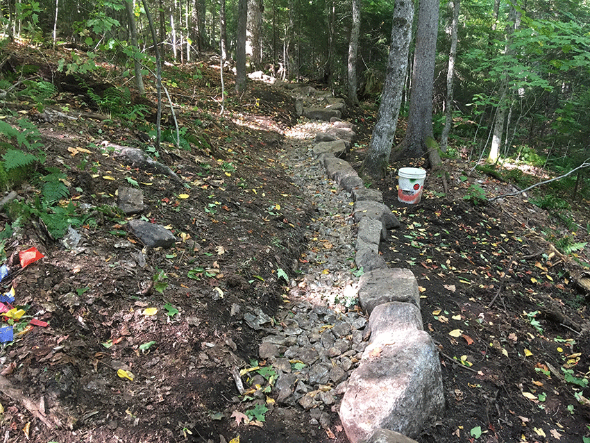
This picture shows a section of the new contour trail with a hard edge lined with large rocks. Crushed stone is used to fill the substrate of the trail. This sustainable trail has been cut into the side slope and rises on a steady, gradual gradient. Note the single step near the top of the picture.
The third step is to fill the trail trench with crushed rock. Trail crews dig out large rocks from areas around the trail corridor and smash these boulders into baseball-sized rocks that are used to form the base of the trail. The depth of the crushed rocks layer range from 6 – 8 inches. This base allows for water to pass through the trail and also stabilizes the trail to prevent erosion. The work to “mine” or “harvest” rocks from around the trail can place a heavy hand on the forest in the trail corridor. Often large pits are dug out to get the rocks, which are then hauled to trail on tarps dragged through the forest or through a cable and pulley system rigged in the trees. This work can trample a lot of the forest understory, but does not cause trees to be taken down.
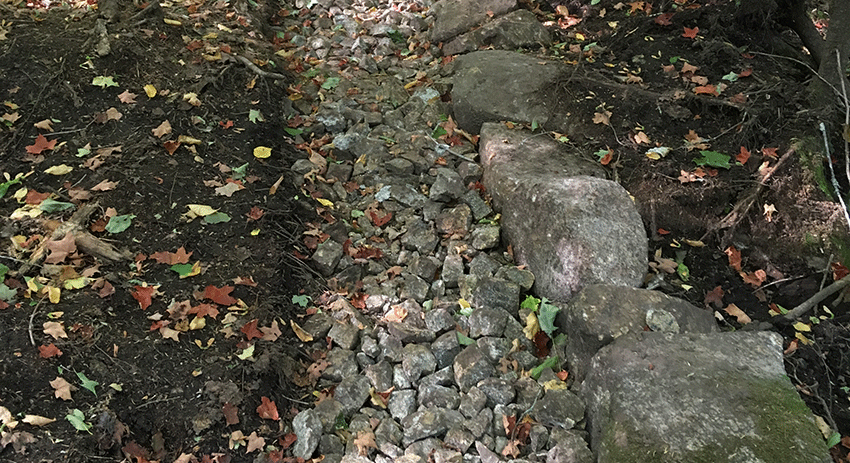
This picture shows a close-up of the crushed stone base that supports the trail. The crushed stones interlock, but allow water to pass through while stabilizing the soils on the trail surface.
A sustainable trail corridor is designed to gradually gain elevation, which minimizes the needs for rock staircases. If a trail utilizes a steady gradient, then few steps are needed and a successful contour trail will have few stone staircases. Trail managers have found that hikers often walk around stone staircases if the stones are of an uneven height, include a large step, or if the stones are wet or ice covered. This has the unintended effect of widening the trail corridor, which leads to erosion and trail damage. The new contour trail includes periodic staircases where there are major terrain obstacles, but generally limits stone staircases to a single step.
The new contour trail up Cascade Mountain will be longer than the current trail that runs straight up the mountainside from Route 73 by a considerable distance, but the architects of the new trail believe it will be much easier to hike, which they argue will make the mountain more accessible.
At some locations the trail is constructed with rock walls on both sides of the trail. This technique is called “turnpiking” and is designed to stabilize the trail into one central, narrow corridor that channels recreational use onto the center tread of the hiking trail. These areas are minimized in the overall design but are necessary in some areas where it is necessary to physically raise the trail tread so that it’s higher than the forest floor to allow water to pass underneath the trail or to protect the sensitive habitat.
The picture above is an example of a section of trail where “turnpiking” has been used to build a durable trail through an area. This section of trail also utilizes a single step, which is a goal in sustainable trail design. A single step encourages hikers to stay on the trail whereas a stone staircase with many steps can actually cause hikers to create side trails due to rock steps being slippery or icy.
The fourth step in the sustainable trail building process is for trail crews to cover the crushed stone trail base with a layer of mineral soils. The soil covering is 4-6 inches deep and designed to come up to the top edge of the line of stones on the downhill side of the trail. The mineral soils on the trail surface make the trail more comfortable to hike and safer because hikers do not have to negotiate a series of roots and rocks and long muddy sections. These contour trails are drier and not as steep as standard hiking trails in the High Peaks. As a result these trails will likely be more accessible to the general public.
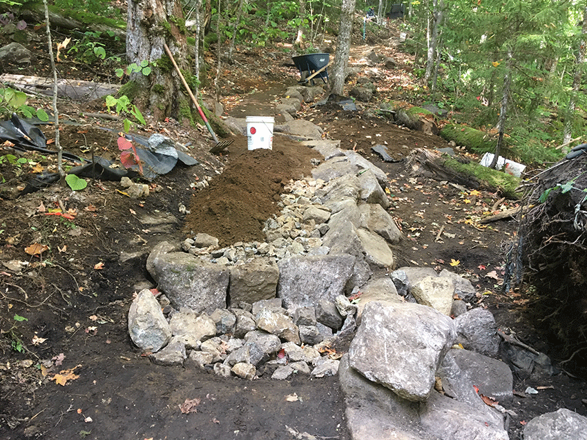
This picture shows the work of trail crews covering the crushed stone trail base with mineral soils and building in a single step into the trail tread.
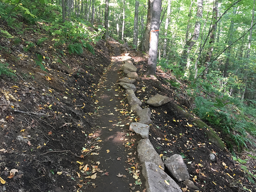
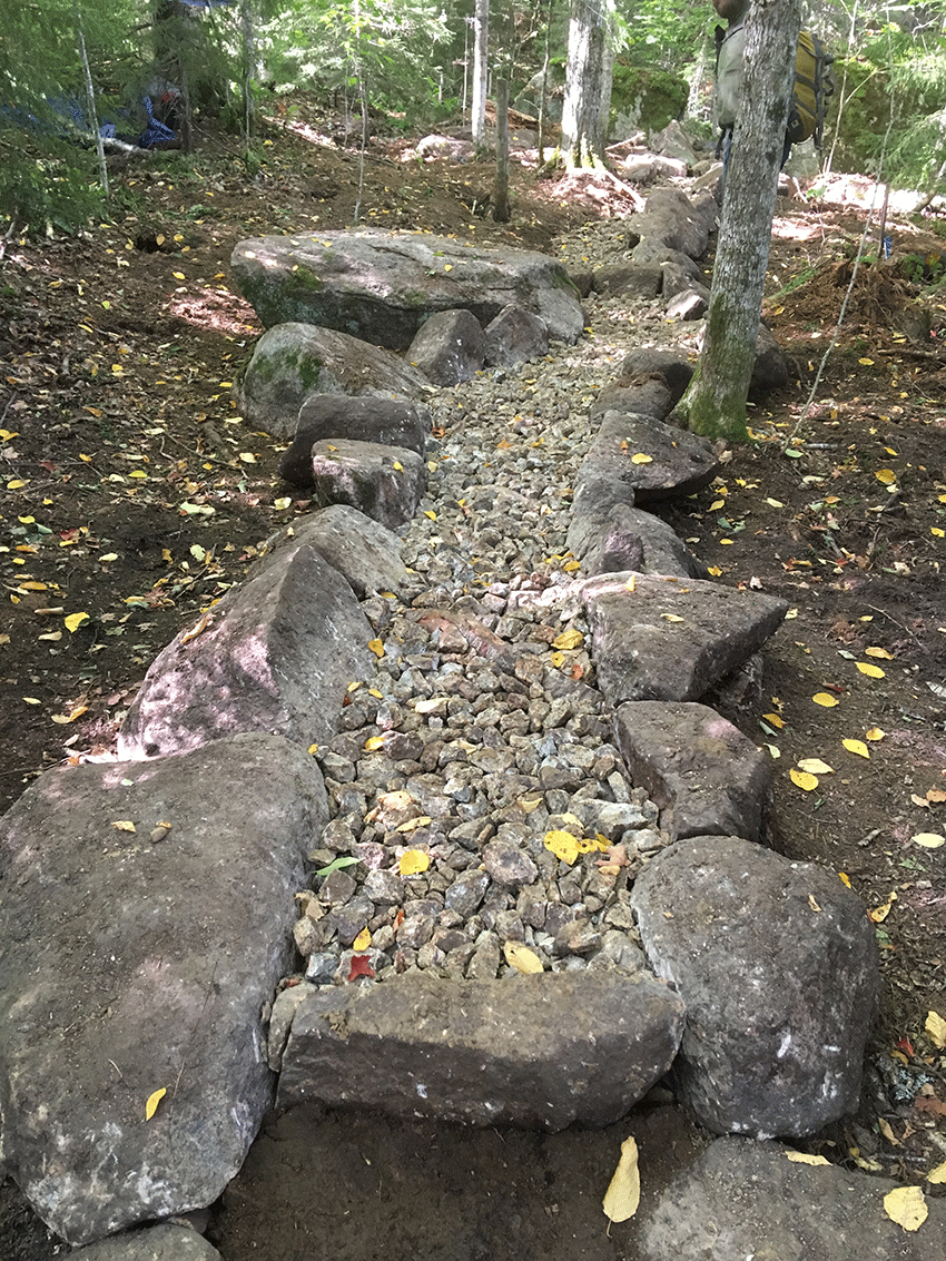
This picture shows a stretch of trail that is nearly finished. The upslope and downslope areas alongside the trail were impacted during trail construction, but will regrow in following years with plants, ferns and small trees.
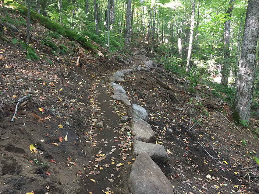
Another view of a nearly completed section of a new contour trail.
One important part the sustainable contour trail construction is that the design is intended to blend in with a wilderness setting and enhance Wilderness management values. These trails are designed to be hiked in a single-file line, are narrow, and blend in with the terrain. They utilize natural materials gathered nearby the trails and are built with hand tools. These trails are designed to uphold and accentuate the wilderness character and the wilderness atmosphere of the area. In many ways the current dismal state of hiking trails in the High Peaks has undermined the wilderness values of the area.
The new trail from the Mount Van Hoevenberg parking lot to the summit of Mountain Van Hoevenberg is expected to completed in 2020. The new trail up Cascade Mountain is expected to be completed in 2021. The Cascade Mountain trail is routed to link up with the existing trail at a point between Cascade and Porter mountains. The ability of trail designers and trail crews to maintain the sustainable contour trail design at higher elevations will be challenging where the terrain is very steep and where soils are thinner. Trail designers believe that trail construction at higher elevations may need more structural devices, such as stone staircases, though the trail ethic calls for use of rock rather than wood. Trail designers are very confident in the viability of these trails at lower elevations. Though they are bullish on them as a new trail standard even at higher elevations, they warn that trail designs at higher elevations will be circumscribed by the realities of steep terrain and limited vegetation.
The tree cutting on these new two new trails, topping over 3 miles constructed so far, has been limited to several dozen trees, consistent with new hiking trails constructed on Coney Mountain, Goodman Mountain, and Moxham Mountain. The DEC has started trail monitoring work on the Cascade and Mount Van Hoevenberg trails. SUNY-ESF has a contract for monitoring of ecological impacts and in 2019 has gathered physical baseline data. Interns from the Excelsior Conservation Corp have also been gathering baseline information. These efforts mark the beginning of scientific monitoring of trail sustainability and public recreational use impacts, which will help the managers of the areas evaluate the effectiveness and utility of these trail designs.
The downside of these new sustainable trails is that they take a great deal of time to build. Progress is slow. In wilderness areas they have to be built with hand tools. Some private trail building crews use mini-excavators to dig out the trail corridor and place heavy boulders on private lands or municipal parks to greatly speed up the process. In theory, these machines could be used in Wild Forest areas, but this approach has not yet been pioneered anywhere in the Adirondack Forest Preserve on a hiking trail. So far there is no hard-and-fast rule for the length of new contour trail that a trail crew of five people can be expected to build within a certain amount of time or the costs of building a mile of this type of new trail.
Protect the Adirondacks will continue to monitor the construction of these new contour hiking trails and their performances once they are opened. Right now these trails hold a great deal of promise and point us all towards a future where sustainable trails in the High Peaks become a reality as opposed to a dream. The challenge in the High Peaks is immense because we need to rebuild and re-route nearly 200 miles of existing hiking trails and build another 100 miles of sustainable trails on all of the “trailless” peaks. The current pace of sustainable trail construction makes this task formidable. Clearly a much bigger effort is needed beyond that the three trails crews, inmate labor, and scattered volunteers that have been deployed this year. A massive effort is needed where the state and private entities fund two dozen highly trained trail crews, that number into the hundreds of trail workers, to rebuild the trails of the High Peaks and create a more perfect wilderness. Even if a massive effort can be organized, this work will take many years.
Trail building in the High Peaks Wilderness should be part of a new comprehensive management program that integrates public education, facilities for parking and camping, and scientific monitoring of natural resources and public use impacts. In many ways the sustainable trail is the link that threads through and ties together effective wilderness management. The new contour trails under construction on Cascade Mountain and Mount Van Hoevenberg help us glimpse a positive future that fulfills the idea of active wilderness management where trails blend in with and enhance wilderness values, rather than undermine them. As things stand now, the new trails on Cascade Mountain and Mount Van Hoevenberg lay down an example, where theory is turned into practice, and where the art and science of natural resource stewardship and public outdoor recreational management in a Wilderness area are significantly advanced in a way that we have not seen before in the Adirondack Park.


