Protect the Adirondacks calls on state leaders to act boldly to expand Wilderness lands in the Adirondack Park. The protection of the former Finch, Pruyn and Company lands by the Nature Conservancy creates a major opportunity to significantly expand the High Peaks Wilderness area. Three tracts from this land purchase border the High Peaks Wilderness — the MacIntyre East Tract, the MacIntyre West tract, and the Boreas Pond tract, which total nearly 35,000 acres. Over 25,000 acres of these lands are ripe for Wilderness classification. In the southern Adirondacks, the Nature Conservancy also purchased former Finch lands in the foothills west of Northville. By reclassifying existing roughly 9,000 acres of existing Wild Forest lands and classifying roughly 3,000 acres of newly purchased lands a new 12,000-acre West Stony Creek Wilderness area could be created.
See press release calling for 36,500 acres of new Wilderness lands on the Adirondack Forest Preserve.
This is a major opportunity to provide New York’s best wildlands protections. Not all the lands being transferred by the Nature Conservancy make sense for the Wilderness designation, but the majority do. The great legacy and achievement of the Adirondack Park is that it protects the greatest Wilderness system in the Eastern U.S. On these lands, New Yorkers have long committed to lands left alone where nature can exist unfettered by human activities. These are lands where the human footprint is minimized, where wild nature is “untrammeled,” as famously characterized in the National Wilderness Act. Wilderness management is forward looking because it provides the opportunity for ceaseless reclamation by the forest, or the beavers, or storms, of old logging roads, building sites, and other remnants of the land’s human past. The human footprint is confined to narrow foot trails and campsites surrounded by a forest that grows older and more complex year after year.
Tremendous Opportunity to Expand the High Peaks Wilderness Area
The people of the State of New York, and all who care about the Adirondack Park, have a once-in-a-generation opportunity to see a major expansion of Wilderness in the Adirondacks. Governor George Pataki created the William C. Whitney area, reclassified Lake Lila as Wilderness, created the Round Lake Wilderness, and significantly expanded the Five Ponds Wilderness Area and Pepperbox Wilderness Area. Governor Andrew Cuomo has already provided for the creation of the 23,500-acre Hudson Gorge Wilderness area in 2013. Now Governor Cuomo can make an ever more significant contribution to New York’s wilderness heritage. The great benefit to New Yorkers of Wilderness, in addition to preservation of wildlife and wild nature, is that these places will provide timeless outdoor experiences that families can rely upon from generation to generation.
For these reasons, and many more, Protect the Adirondacks advocates that the High Peaks Wilderness Area should be expanded by nearly 25,000 acres with the recent state purchases of the MacIntyre West and MacIntyre East tracts and with the purchase of the Boreas Ponds, which the state is set to buy early in 2016.
Boreas Pond Tract: The Boreas Pond tract has been identified for decades as one of the great ecological and recreational gems in the Adirondacks. This area has long been at the top of state acquisition targets. It was identified by the Commission on the Adirondacks in the Twenty-First Century for Forest Preserve purchase.
This complex pond and wetland system is located on the flanks of the southern High Peaks and is connected by wetlands and waterways to the Au Sable lakes. Like Henderson Lake and Elk Lake, the Boreas Ponds provide stunning views of the High Peaks. Governor Cuomo announced in 2012 that the State of New York would purchase the Boreas Ponds tract as new Forest Preserve lands, part of the historic 69,000-acre state purchase that included the Essex Chain Lakes.
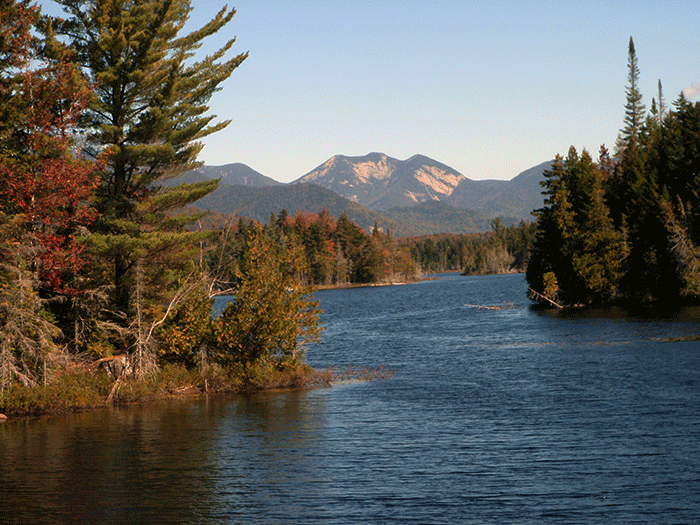
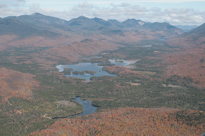
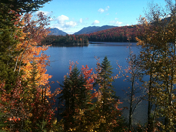
The top two pictures show views of the High Peaks across the Boreas Ponds. The bottom picture is an aerial of the Boreas Ponds with the High Peaks in the background. LeBiere Flow is in the foreground with the Boreas Ponds in the center. PROTECT calls for a paddling staging area and public parking lot within a short carrying distance from LeBiere Flow for canoe access to these lands. Note the Gulf Brook Road in the lower left, which runs through the lower part of the tract.
The Boreas Ponds tract has been in near constant timber management since the end of the American Civil War. Finch, Pruyn and Company maintained the Gulf Brook Road through the center of these lands as its main haul road. It’s a substantial road. Finch also maintained two dams that impact the Boreas Ponds; the first at LeBiere Flow, which also acts as a bridge on the Gulf Brook Road, the second on the Boreas Ponds, which is also a bridge for secondary roads. While the Boreas Ponds tract is criss-crossed with haul roads and tote roads, these will be easily reclaimed by the forest in the decades ahead after public acquisition.
The Boreas Ponds tract also has a number of leased hunting camps that will be removed at the time of state purchase. Two buildings face an uncertain future. Finch, Pruyn built a retreat center overlooking Boreas Ponds in the 1990s where it took clients for outdoor trips. PROTECT believes this building, which has no architectural or historic value, should be removed and the grounds reforested. Out buildings associated with the retreat center should also be removed.
An old log cabin is close to the Gulf Brook Road and LeBiere Flow. This cabin has been reputed to be the oldest building is the Town of North Hudson, though no documentation has been provided to justify this claim. Old military roads passed through this tract in the early 19th Century. PROTECT could support, with proper management restrictions, use of this cabin by the Department of Environmental Conservation for Rangers or as a remote outpost.
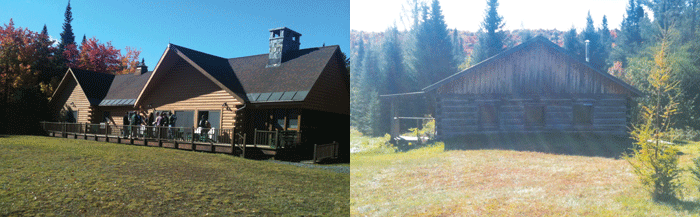
Boreas Lodge and “historic” cabin in North Hudson. PROTECT calls for demolition of the Boreas Lodge and restoration of the site and possible maintenance of the historic cabin for administrative purposes with proper restrictions.
PROTECT calls for over 13,000 acres of the Boreas Ponds tract to be classified as Wilderness and around 8,000 acres as Wild Forest. We recommend that the Gulf Brook Road be used as boundary. The road should be classified as Wild Forest and provide paddlers with access to LeBiere Flow. We do not support public automobile access beyond a paddling or hiking staging area at LeBiere Flow. We also recommend that the Casey Brook tract be classified as Wilderness.
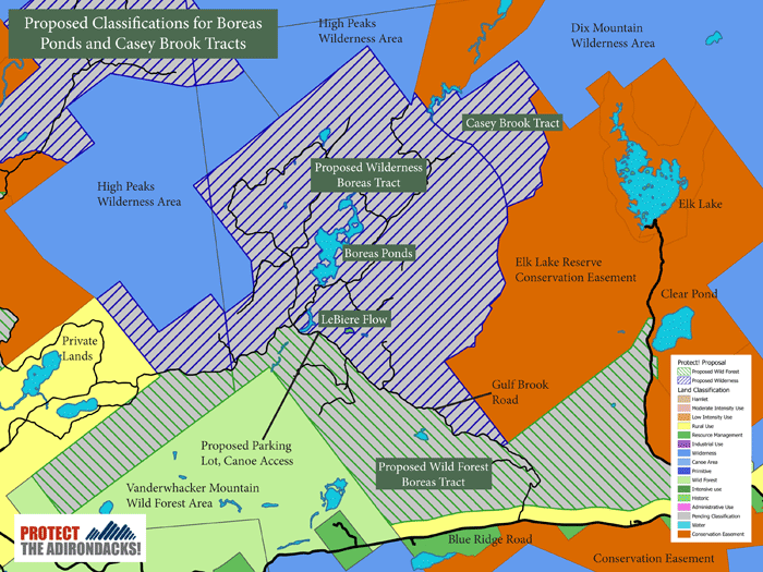
The map above details the proposal by Protect the Adirondacks to classify new state Forest Preserve purchases around the Boreas Ponds as a mixture of Wilderness and Wild Forest. PROTECT calls for over 13,000 acres of these lands to be classified as Wilderness and over 8,000 acres as Wild Forest. We advocate that the Gulf Brook Road should be part of the Wild Forest area and open for six miles so that the public can access the Boreas Ponds with a canoe staging area.
Casey Brook Tract could be an Important Wilderness Bridge: Protection of the Casey Brook tract (see map above) through an agreement by the Nature Conservancy and the Elk Lake Reserve (click here for background information praising this visionary agreement) protects lands on the eastern side of the Boreas tracts. Through this agreement the Casey Brook tract was protected as Forest Preserve and a conservation easement protects the entire Elk Lake Reserve. Casey Brook provides a land bridge that could be used to combine the High Peaks Wilderness Area and the 45,000-acre Dix Mountain Wilderness area into one large Wilderness.
Gulf Brook Road, LeBiere Flow Dam, Boreas Ponds Dam: PROTECT recommends using the Gulf Brook Road as the Wild Forest-Wilderness area boundary. In this way, the public could drive the six miles from the Blue Ridge Road to a public parking area/canoe staging area at LeBiere Flow. This will provide a Lake Lila-style access to the Boreas Ponds waterway for paddling and camping.
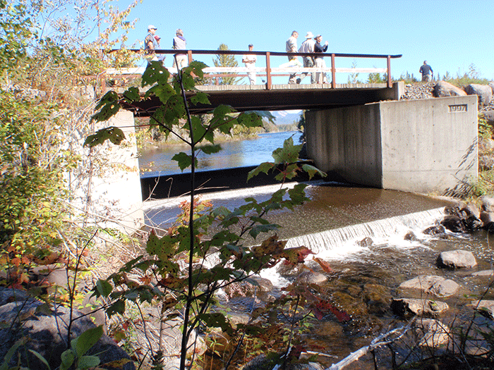
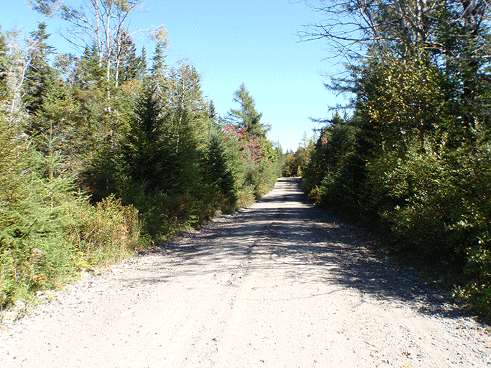
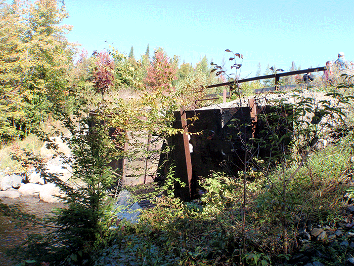
These three pictures show (from the top) the dam at Lower Boreas Pond. This dam is fairly new and in good condition. The middle picture shows a typical stretch of the Gulf Brook Road. The lower picture is the dam and LeBiere Flow, which has been repaired recently but needs work. The Gulf Brook Road passes over this dam.
The dams have created a terrific flat water paddling opportunity. The fishery in the Boreas Ponds is a Brook Trout fishery; there are no bass or lake trout in these ponds. There are Brook Trout above and below the LeBiere Flow dam. It’s important to note that three dams have washed out over the years in the High Peaks Wilderness at the Flowed Lands, Marcy Dam, and Duck Hole. The Boreas Ponds fishery is not dependent upon the dams for its longterm stability or viability.
Motorized Uses on the Forest Preserve Should be Confined to Areas Classified as “Wild Forest”: PROTECT believes that public motor vehicle use in the Forest Preserve should be confined to Wild Forest areas, which currently allow motor vehicle roads and snowmobile trails.
The Essex Chain Lakes Complex Unit Management Plan is highly controversial because of the way longstanding state laws were bent or ignored to allow various motorized uses that were long forbidden (see PROTECT’s reflections on this deeply flawed plan Part 1, Part 2 and Part 3). Protect the Adirondacks is alarmed by creeping efforts to extend public motor vehicle use into the Park’s wildest areas.
To confine motor vehicle use to Wild Forest areas, PROTECT recommends that the Wilderness-Wild Forest boundary in the Boreas tract should be the Gulf Brook Road. Roads have commonly been used as classification boundaries in the Forest Preserve. The road that provides access to Low’s Lake forms the boundary between Wilderness and Wild Forest. The Bear Pond Road in the western Adirondacks separates part of the Watson’s East Triangle Wild Forest area from the Pepperbox and Five Ponds Wilderness. In addition to being a clear boundary, these roads have also provided public access to these Wilderness lands.
Use of the Gulf Brook Road as the southern boundary of the High Peaks Wilderness would create a historic expansion of the Park’s most famous and visible Wilderness area and allows for combining the High Peaks Wilderness with the Dix Mountain Wilderness Area.
New MacIntyre Tracts should be No-Brainers as New Additions to the High Peaks Wilderness Area
Over 13,000 acres of former Finch, Pruyn lands were added to the Forest Preserve in the last two years in the highlands on both side of the Tahawus mine in Newcomb. These tracts are known as the MacIntyre West and MacIntyre East tracts. PROTECT calls for 11,500 acres of these lands to be classified as Wilderness and 1,500 acres as Wild Forest.
MacIntyre West Tract: The state purchased the 5,700-acre MacIntyre West tract in 2014 from The Nature Conservancy. Just north of this tract is another 1,500 acres of lands purchased from the Open Space Institute in 2012. At nearly 7,000 acres these lands are surrounded on three sides by the High Peaks Wilderness Area. These lands include Mount Andrew, Lake Andrew, and Santanoni Brook. This tract will improve public access to the Santanoni Range.
PROTECT calls for a Wilderness classification of the entire MacIntyre West tract.
MacIntyre East Tract: This 6,200 acre tract is bordered by the Opalescent River to the north and LeClair Brook to the south. The High Peaks Wilderness is to the north and east, with the Tahawus Mine to the west. Over 7 miles of the Opalescent River winds through these lands. Click here to see a short video of these lands. The Opalescent River flows into the Hudson River just south of the Tahawus Mine. This tract includes over five mines of the Hudson where the river is intermingled with wetlands, the Sanford Lake Railway line, and the Tahawus Road. Hikers state that the MacIntyre East tract could provide better access to Allen Mountain (though others argue that Allen Mountain should always remain a challenging hike).
PROTECT urges that these lands should largely be classified as Wilderness. We envision the northern section with the Opalescent River, totaling around 4,500 acres, should be Wilderness and 1,700 acres along the Hudson River corridor should be classified as Wild Forest.
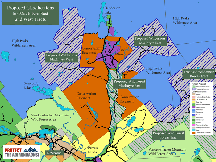
The map above shows the MacIntyre East and West tracts in the highlands on the south side of the High Peaks Wilderness area. Protect the Adirondacks is advocating for 11,500 acres of newly purchased lands to be classified as Wilderness and 1,500 acres as Wild Forest.
Tremendous Opportunity to Create a New West Stony Creek Wilderness Area
Other newly purchased former Finch, Pruyn lands in the southern Adirondacks offer the cornerstone of a new Wilderness area. Protect the Adirondacks calls for the creation of a new West Stony Creek Wilderness, consisting of 3,025 acres of lands recently purchased by the State of New York from The Nature Conservancy and over 8,925 acres of existing Forest Preserve lands in the towns of Benson (Hamilton County) and Mayfield, Northampton, and Bleecker (Fulton County). This new wilderness connects to the existing Silver Lake Wilderness and provides a wilderness gateway to the southern Adirondack Park. This Wilderness is centered on the wild and beautiful West Stony Creek.
West Stony Creek runs wild and free through the heart of what could be a new West Stony Creek Wilderness. This area is current a motorless area with no roads or snowmobile trails. Research has identified the Wilderness characteristics of this wild tract of land.
Some 8,925 acres are currently classified as Wild Forest (see map below) in five different tracts in the Shaker Mountain Wild Forest. With the newly purchased lands, part of the former Finch Paper holdings, these Wild Forest tracts should be consolidated into a new, cohesive 12,000-acre Wilderness area that will protect a large intact landscape. This is an accessible wild area opening up Wilderness access within an hour of nearly a million people from Albany to Utica, just north of the Thruway. Most Wilderness areas are more remote in the central Adirondacks.
These lands include some of the wildest and most remote parts of the Shaker Mountain Wild Forest area. Many smaller mountains and ridges are interlaced with wetlands and beaver ponds. These lands are dominated by intact mature and old growth forest systems on the Forest Preserve and recovering forests on the newly purchased lands.
Graduate research at SUNY-ESF found significant “wilderness characteristics” in the West Stony Creek area. Today, the West Stony Creek tract, though classified as Wild Forest in the Shaker Mountain Wild Forest, is an 8,000 acre roadless area that is centered on West Stony Creek, a meandering “Scenic” river. The wilderness character of these lands led state planners to reroute the beginning of the Northville-Placid Trail (NPT) through this area. The NPT is iconic in the Adirondack Park, and the addition of this new Wilderness area at the southern end redefines the trail. Another 8% of the entire NPT trail would thus be located in a Wilderness area.
A Wilderness classification is consistent with current state planning. The Shaker Mountain Wild Forest UMP states that this area “will be managed for pedestrian use only, with the only trails proposed consisting of the NPT relocation and West Stony Creek trail.”
Show your support for this new Wilderness Area by signing our new online petition.
Read a letter to state leaders advocating for this new Wilderness area. Click here for more background information on the creation of a new West Stony Creek Wilderness area. Click here for pictures from a hiking trip to the West Stony Creek river valley.
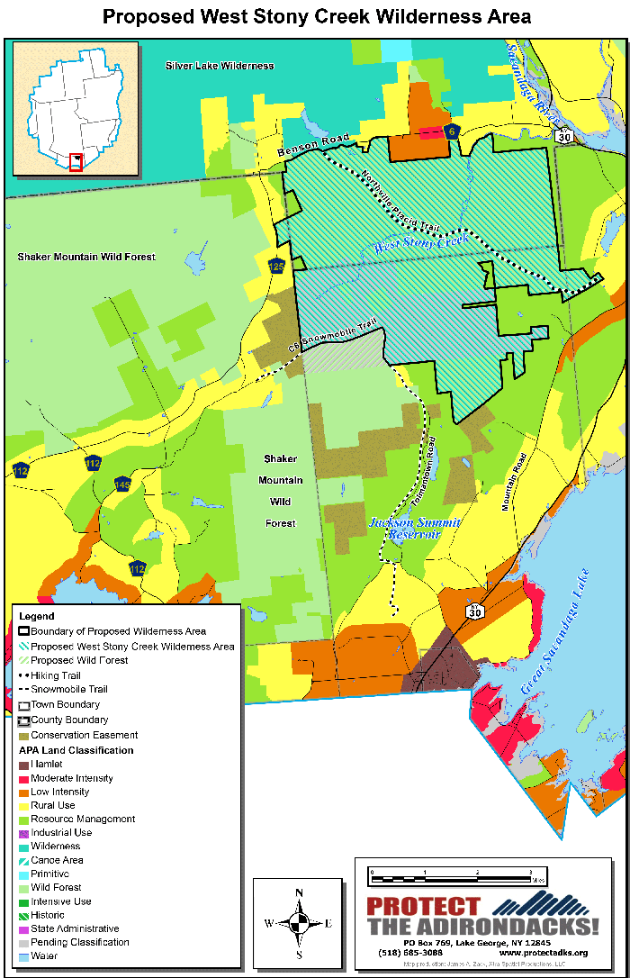
The map above shows the proposed West Stony Creek Wilderness in the mountains west of Northville.


