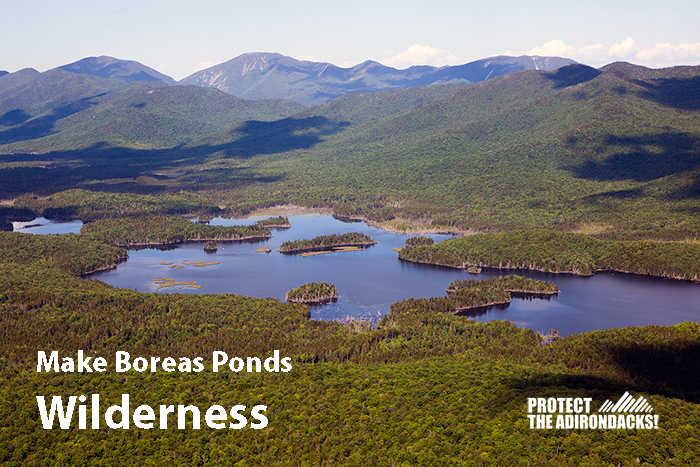
Compromise protects Boreas Ponds as Wilderness, while enabling easy public access and a variety of recreational uses on neighboring Wild Forest lands
Wilderness Classification for the Boreas Ponds is major milestone in the history of the Adirondack Park, only 140,000 acres of Wilderness Approved since 1970; 25,000 acres approved alone on February 2, 2018
The Adirondack Park Agency today approved the Boreas Ponds as the state’s newest Wilderness lands in the Adirondack Forest Preserve. The APA approved 11,400 acres of lands around Boreas Ponds as Wilderness and nearly 15,000 acres of other lands that border the High Peaks as Wilderness.
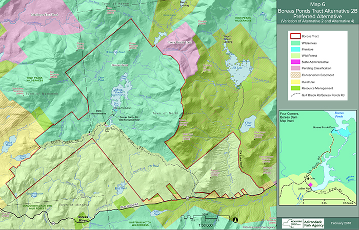
This is the map published by the APA. The two “pending classification” tracts are also being proposed for Wilderness. This map details the Wilderness-Wild Forest boundary line, which runs just north of the Gulf Brook Road.
The High Peaks Wilderness was expanded by 25,000 acres today. That’s a historic accomplishment. The Boreas Ponds and 11,000 acres around them was classified as Wilderness and that too is a great accomplishment.
Since 1970, the Adirondack Forest Preserve has seen an expansion of lands classified as Wilderness, Primitive and Canoe from 1,072,000 acres to 1,210,000 acres, roughly a growth of 138,000 acres in nearly 50 years. Over 25,000 acres was added by the Adirondack Park today at its meeting. Clearly, gaining new Wilderness lands in the Adirondacks is always challenging, always difficult, always hard. This puts into perspective the accomplishment of the APA to expand Wilderness in the Adirondack Forest Preserve by 25,000 acres.
The APA’s decision caps a process that started with the state’s acquisition of 69,000 acres of the former Finch, Pruyn & Company lands from 2012-2016, purchased from The Nature Conservancy. Protect the Adirondacks congratulates Governor Cuomo, the Adirondack Park Agency and the Department of Environmental Conservation for this classification. We salute the great work of The Nature Conservancy for acquiring and protecting this land.
Public uses on these newly classified lands will be determined through Unit Management Plans (UMPs). The Wilderness lands around the Boreas Ponds will be added to the High Peaks Wilderness and the Wild Forest lands will be added to the Vanderwhacker Mountain Wild Forest area. Both UMPs are expected to be revised in the summer of 2018. Under this classification, public motor vehicle use could be as close as ¼ mile to the shoreline of Boreas Ponds. Under this classification, the Gulf Brook Road could be retained as a Forest Preserve road open to bicycles and motor vehicles and used as a snowmobile trail. The Wilderness area around the Boreas Ponds limits public uses to canoes, kayaks or rowboats, hiking, cross-country skiing and camping.


