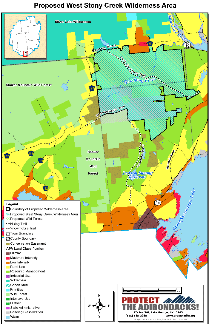
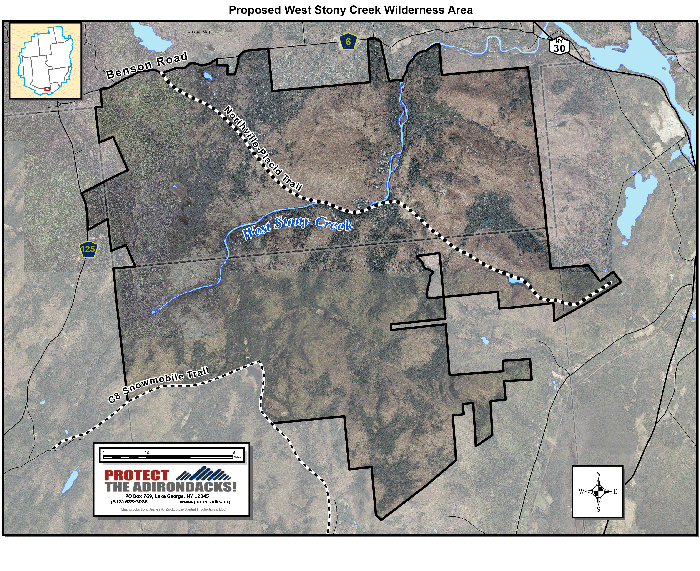
Protect the Adirondacks has identified a potential new 12,000-acre Wilderness area in the southern Adirondack Park. The new West Stony Creek Wilderness consists of 3,300 acres of lands recently purchased by the State of New York from The Nature Conservancy and over 8,925 acres of existing Forest Preserve lands in the towns of Benson (Hamilton County) and Mayfield, Northampton, and Bleecker (Fulton County). This new wilderness connects to the existing Silver Lake Wilderness and provides a wilderness gateway to the southern Adirondack Park.
Some 8,925 acres are currently classified as Wild Forest in five different tracts in the Shaker Mountain Wild Forest. The newly purchased lands, part of the former Finch Paper holdings, will allow these Wild Forest tracts to be consolidated into a new, cohesive 12,000-acre Wilderness area that will protect a large intact landscape. This is an “accessible wilderness” opening up Wilderness within an hour of nearly a million people from Albany to Utica, just north of the Thruway. Most Wilderness areas are in the central Adirondacks.
The Forest Preserve lands contain mature forests with many trees over 150 years old. Over six miles of West Stony Creek meanders through this tract, connected to various wetland systems. West Stony Creek, whose waters run into the Sacandaga Reservoir and then into the Hudson River, is classified and protected under the NYS Wild, Scenic, and Recreational Rivers Act. It is generally high and rugged country, containing ten unnamed peaks in the 2,000-foot range, and numerous ponds, beaver ponds, streams and wetlands, including several tributaries that feed Stony Creek. Bald peaks are present, such as Pinnacle Mountain (as locally named, not to be confused with the larger Pinnacle Mountain near Shaker Mountain), and provides great views of the Great Sacandaga Reservoir and the southern foothills of the Adirondack Park.
In recognition of the wild character of this area, the Northville-Placid trail (NPT) has been rerouted through the West Stony Creek tract as part of the Shaker Mountain Wild Forest Unit Management Plan (UMP). This will provide a stunning new beginning for this landmark trail that takes hikers off a trail on the road and put them in a wild setting for nine miles before they enter the Silver Lake Wilderness area. Just as the northern end of this iconic Adirondack trail is in the High Peaks Wilderness, now the southern end will also terminate in a wilderness area, enhancing the wilderness experience of both through and day hikers.
Show your support for this new Wilderness Area by signing our new online petition.
Read a letter to state leaders advocating for this new Wilderness area.
Natural Features
The proposed new West Stony Creek Wilderness Area contains many beautiful, complex, and fragile natural areas. These include mature and old growth forests, bogs, the West Stony Creek corridor, extensive wetlands, and both northern upland forests and high elevation spruce-fir communities.
The Mud Pond Bog is an extensive bog area that blends into a large hemlock forest. This area is dominated by northern hardwoods upland forests, much of which was harvested in the late 19th century. These lands contain sections of old growth, largely in rugged valleys where logging was difficult. High elevation spruce-fir ecosystems are present as well as sugar maple ecosystems on slopes and lowlands. Canadian burnet, a regionally rare flower, is also found there.
Mud Lake is an attractive beaver pond with floating islands of sphagnum moss, drowned trees, and beaver lodges. Bald eagles have been reported along West Stony Creek, and the area contains all the typical Adirondack wildlife species.
The newly purchased former Finch lands have been heavily lumbered along roadsides and in low elevations. High elevation forests were lightly lumbered. A network of roads and tote trails are plainly visible on the recently purchased lands. Forest Preserve protection will allow these lands to recover over the years. The road system is in disrepair in many places and there are signs of an intensive period of trespassing with 4-wheel-drive off-road and all terrain vehicles (ATVs).
In the era of global climate change, the most resilient landscapes are those with intact natural systems. That the highlands above various communities contain an intact Wilderness area means greater protections during extreme weather events.
Recreational Features
In addition to the rerouted section of the Northville-Placid Trail, this new Wilderness area has several other key recreational opportunities that should be developed for public use. These lands are very rugged, encompassing several ranges of mountains and hills in the 2,000-foot range. These hills have local names, including Maple and Gifford Hills, to the north of Mud Pond, Ash, Tripoli, Deer, and Cyrus Hills to the southwest, and Pinnacle Mountain to the south (not to be confused with the larger Pinnacle Mountain to the west.) These small mountains contain numerous rock ledges and have steep cliffs and rise sharply near the top. These characteristics have preserved old growth forests and scenery. Some of them have great views from the top, but most of them are forested over the top, with no views.
Pinnacle Mountain is prominently seen from NYS Route 30. It has an old and overgrown feldspar mine on its eastern slope, described in Barbara McMartin’s Discover the Southern Adirondacks. Pinnacle Mountain has two overlooks, one to the south looking over Mayfield and Sacandaga Lake, and one to the east and north over Sacandaga Lake. Access to Pinnacle needs to be improved. A surprising amount of these lands were not heavily logged because the terrain is too rugged. This includes virtually all of the mountaintops and, of course, the wetlands.
An unnamed mountain just south of Mud Pond, locally known as “Big Oak Hill,” has rock ledges that expose a 180-degree view of Sacandaga Lake to the east and south. This is described as the “Mud Lake and Overlook Cliff” hike by McMartin.
Northern parts of the West Stony Creek Wilderness area front onto the Benson Road and one western section fronts on County Route 125. The C8 snowmobile trail borders the Wilderness area in the southwest.
Wilderness Classification and Management
Almost 4,000 acres of these lands, which will become part of the Forest Preserve, are currently “pending classification” after the state’s purchase. The Department of Environmental Conservation (DEC) will make a proposal for the management and classification of these lands and other recently purchased lands. The Adirondack Park Agency (APA) will hold a classification hearing that most likely will consider several options. Once the hearings are completed, the APA will make a formal recommendation that will be forwarded to the Governor for final approval.
These lands include some of the wildest and most remote parts of the Shaker Mountain Wild Forest area. Many smaller mountains and ridges are interlaced with wetlands and beaver ponds. These lands are dominated by intact mature and old growth forest systems on the Forest Preserve and recovering forests on the newly purchased lands.
Graduate research at SUNY-ESF found significant “wilderness characteristics” in the West Stony Creek area. Today, the West Stony Creek tract, though classified as Wild Forest in the Shaker Mountain Wild Forest, is an 8,000 acre roadless area that is centered on West Stony Creek, a meandering “Scenic” river. The wilderness character of these lands led state planners to reroute the beginning of the Northville-Placid Trail (NPT) through this area. The NPT is iconic in the Adirondack Park, and the addition of this new Wilderness area at the southern end redefines the trail. Another 8% of the entire NPT trail will be located in a Wilderness area.
A Wilderness classification is consistent with current state planning. The Shaker Mountain Wild Forest UMP states that this area “will be managed for pedestrian use only, with the only trails proposed consisting of the NPT relocation and West Stony Creek trail.”
Major Snowmobile Trail Unaffected by Wilderness Proposal
The existing Jackson Summit/Tomantown Road C8 snowmobile corridor, a major snowmobile trail, is unaffected by the proposed new Wilderness area.
We Need More Wilderness Lands in the Adirondack Forest Preserve
Wilderness areas protect whole ecosystems. In the Adirondack Park, Wilderness areas allow for broad forested landscapes to be permanently protected in a state where natural processes can proceed year after year unimpeded by human interference. The best way to permanently protect a forest system is through Wilderness classification and management.
Wilderness opportunities grow fewer each year as more and more places are developed across the U.S., especially east of the Mississippi River. Lands that are classified and managed as Wilderness areas become part of the relatively small and specially recognized pool of truly wild places in the eastern U.S.
People need quiet, untrammeled, motorless places where they can unplug and get away. The solitude and wildness of a Wilderness area, accessed by a narrow hiking trail, or bushwhack, is a rare experience that becomes more important and more valuable with each passing year. We need more Wilderness areas in the southern Adirondacks closer to major Upstate New York population centers.
Wilderness areas do not allow motor vehicle use and thus do not have roads and snowmobile trails. Wild Forest areas in the Adirondacks have seen infestations of terrestrial invasive species along roads that penetrate into their interiors. Wilderness classification provides greater protections against invasive species.
After the classification hearings of 2013, there are now over 1,217,000 acres of Wilderness, Canoe and Primitive areas compared with over 1,320,000 acres of Wild Forest, Intensive Use and Historic areas. There remains across the Forest Preserve well over 100,000 acres more classified Wild Forest lands, which permit various types of motor vehicle use, than non-motorized Wilderness lands.
Show your support for this new Wilderness Area by signing our new online petition.
Next Steps
Protect the Adirondacks anticipates formal classification proposals and hearings by the APA and DEC over the next year. PROTECT will advocate for a full evaluation of a new West Stony Creek Wilderness Area as part of this public review.


