The Adirondack Park Agency is holding a public hearing on a proposed draft plan for new “community connector” snowmobile trails. The proposed new trail network will link the communities of Newcomb with North Hudson and Minerva. “Community connector” snowmobile trails are wide, road-like trails that link together communities and amenities, such as gas stations and restaurants. This is part of a major effort by the Department of Environmental Conservation (DEC) and the Adirondack Park Agency (APA) to construct a new snowmobile trail network across many units of Forest Preserve lands, conservation easement and private lands. The new trails on the Forest Preserve represent the largest expansion of motor vehicle use in the history of the Forest Preserve.
Click here for a copy of the Community Connector Trail Plan. See the APA press release about the public hearing.
Public comments must be submitted by June 15, 2015. Click here for information about where to submit a letter or email or see more information  below.
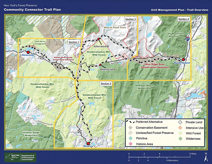
Proposed new community connector snowmobile trails from Newcomb to Minerva and Newcomb to North Hudson. The North Hudson route has two alternatives shown on this map.
General Comments
Problems with Class II Community Connector Trails: Construction of Class II Community Connector trail require extensive construction and terrain modifications to facilitate large bulldozer size groomers and high speed snowmobiling. These trails require extensive use of heavy machinery to excavate, widen, grade and cut bench cuts into trails. These machines remove all understory, require extensive tree cutting of trees over 3″ diameter at breast height (DBH), and require the removal of thousands of trees less than 3″ DBH. These road-like “trails” require oversized bridges as well as extensive use of deep waterbars top control stormwater impacts from open roadway and change in forest cover. These 9-12 foot wide, and often wider, clearcuts snake through the Forest Preserve for miles. PROTECT finds that these trails are the most intensive and damaging types of trails built in the Forest Preserve today.
Trails are Designed, Built for High-Speed Snowmobiling and Maintenance with Heavy Duty Motor Vehicle Groomers: These community connector trails are built for high speed snowmobiling and maintenance by multi-ton trail groomers. These trail require extensive widening and excavating. These trails bear no resemblance with foot trails, cross-country ski trails or mountain bike trails. No other trail in the Forest Preserve is built to accommodate motor vehicles operating at high rates of speed.
Plan Fails to Provide Snowfall Data: The plan provides little useful information about long-term snowfall data for snowmobiling in North Hudson or Minerva.
In the “Response to Public Comments” on this matter the DEC provides an inadequate response.
DEC should include longâ€term snowfall data in UMPs to support construction of new trails.
These proposals are for multiple use trails so snowfall is not required for all uses.
DEC is justifying not examining snowfall data because it plans to use these trails for multiple uses, though the principal use that shapes how these trails will be designed and constructed is not supported by good data. This is not how public policy decisions should be made.
PROTECT is concerned that a grand trail network is being planned and constructed at great expense and that it is unlikely that snowfall with be adequate to make these trails operational.
Ecological Integrity Impacts not Fully Assessed: The plan fails to fully assess the impacts of 10-12-foot-wide corridors that have been clearcut and excavated on the ecological intergrity of the surrounding forest systems. The impacts of roads on forest systems can be highly disturbing to the health of the ecosystem. The APA needs to fully evaluate the ecological impacts of these wide road-like trails.
Multiple-Use Trails Remain a Public Policy Fallacy: DEC states that these trails will be multiple use trails. There are few successful multiple use trails on the Forest Preserve today. The Seventh Lake Mountain Community Connector Trail, in the Moose River Plains Wild Forest, a major new community connector snowmobile trail is near the population centers of Inlet and Old Forge as well as two state campgrounds, yet this trail sees little non-snowmobiling use and is largely impossible to mountain bike.
Costs: The proposed plan should provide an accounting of the costs to build these trails. The State Land Master Plan requires schedule information and the APA should require cost information. Nor has the DEC ever examined the ecological impacts of these trails. The DEC has never provided complete and accurate information on the costs the build these trails and the APA should require this information.
A great deal of stewardship funding from the Environmental Protection Fund (EPF) has been dedicated to snowmobile trail construction by the DEC, yet cost figures have not been readily provided.
Snowmobile Trail Closures: The plan proposes to close over 11 miles of snowmobile trails in the interior that are not actively used. One trail to be closed separates and, constitutes the boundary between, the Vanderwhacker Mountain Wild Forest area and the Hoffman Notch Wilderness area. PROTECT supports these actions and believes snowmobile trails in the remote interior should be closed. Yet, the mileage of new snowmobile trails in this proposed plan is 14 miles, which will negatively impact the Forest Preserve.
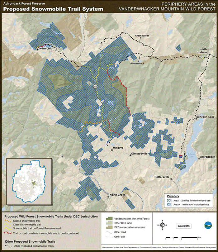
This map shows areas close to motorized corridors and areas more remote from motorized uses. This map also shows snowmobile trails proposed to be closed.
Newcomb to Minerva Trail
The draft plan proposes to link Newcomb and Minerva with a new road-like snowmobile trail that roughly parallels Route 28N. While this proposal follows the highway and avoids the interior of Forest Preserve areas, this route has many obstacles with private landowners, severe terrain constraints, and crossing the Boreas River. The comments below highlight the issues with this trail.
It’s important to note that DEC withdrew a controversial new trail would have run east of the Hudson River through the Vanderwhacker Mountain Wild Forest area and required many miles of newly cut road-like trails through the Forest Preserve. DEC will likely attempt to resurrect this section of trail, which would connect with the Polaris Bridge over the Hudson River, as part of its planning for the Essex Chain Complex Unit Management Plan. This plan will likely be released in late 2015.
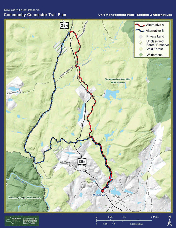
The preferred alternative is to route a trail along Route 28N. A secondary route is to utilize the railroad corridor along the Boreas River.
100% of Newcomb to Minerva Snowmobile Trail Should be Marked on State Land, Approved on State Conservation Easement Lands, and Approved by all Affected Private Land Owners: There are many gaps in the Newcomb to Minerva Snowmobile Trail. The APA should not approve a theoretical trail or a trail that is only partially feasible. PROTECT notes that there is no existing approval to route a critical section of trail through the Hyslop Conservation Easement tract. PROTECT is also aware of opposition from a number of private landowners whose lands are identified for this trail. The APA should not approve a trail unless DEC can verify that 100% of the trail is feasible. Under no circumstances should any portion of this trail be built until 100% of the trail has been legally detailed.
Proposed Roadside Trail on Route 28N is a Hazard: A long stretch of the Newcomb to Minerva trail is proposed to be located alongside Route 28N. The original Vanderwhacker Mountain Wild Forest UMP had eight options to connect Minerva to Newcomb. If there was one good option, the eight options would not have been listed. While the roadside trail along Route 28N would appear to cause the least impact, it must be noted that a new snowmobile trail on the roadside raises public safety concerns.
Proposed Roadside Trail on Route 28N and could Negatively Impact Old Growth Forests at South End: A long stretch of the Newcomb to Minerva trail is proposed to be located through challenging terrain that will cause enormous ecological damage to forests as well as face severe topographical obstacles, such as ledges and steep slopes. The southern part of the proposed trail is planned through beautiful old growth forest. This trail will be highly damaging to the natural resources of the Forest Preserve. The plan provides little information about the composition of the forest this trail will be built through.
New Snowmobile Bridge over the Boreas River Violates the Wild, Scenic and Recreational Rivers Act: Plans to build a new snowmobile bridge over the Boreas River, a classified Scenic River, for motor vehicle use violates the Rivers Act, which forbids motor vehicle bridges over Scenic Rivers. This bridge appears to be a new public non-conforming use. The APA should require an explanation from the DEC on how it plans to comply, or seek statutory changes, to the Rivers Act.
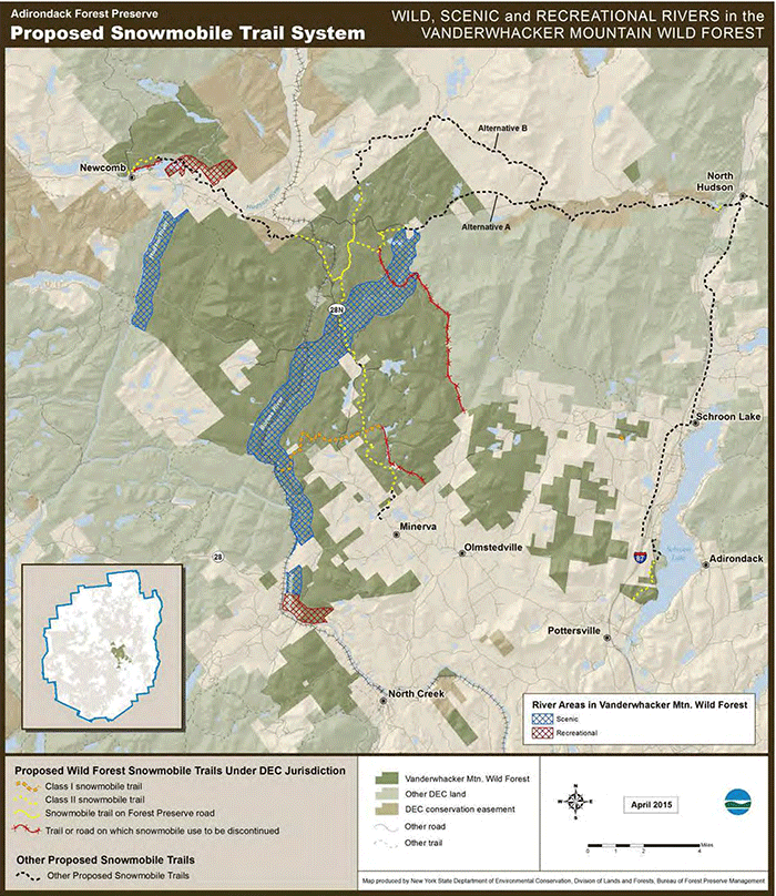
This map shows Wild, Scenic and Recreational River corridors that impact decision making and planning for routing new community connector snowmobile trails. DEC made the decision to postpone planning for snowmobile use with the Hudson River corridor, but the Newcomb to Minerva snowmobile trail will need to comply with the Rivers Act for the Boreas River, a classified Scenic River.
Crossing of the Boreas River Remains an Acute Obstacle: It is PROTECT’s understanding that the NYS Department of Transportation does not allow snowmobile traffic on bridges on state roads. This creates a major challenge for the DEC’s plans that the APA should fully investigate. Siting and construction of this new bridge over a Scenic River in close proximity of Route 28N for motorized uses will be a major engineering obstacle.
In the “Response to Public Comments” on this matter in the final draft UMP, the DEC provides an inadequate response. Here is what the DEC stated:
Boreas River Bridge
A snowmobile bridge would be very expensive and DEC has not provided any documentation
showing DOT support for attaching a bridge to the existing motor vehicle bridge.
Construction will only occur after funding is identified and any required permits and
agreements are issued.
The APA should require a much more detailed explanation from the DEC on the true costs to build this bridge.
North Hudson to Newcomb Trail
There are far fewer issues for the snowmobile trail network plan to connect Newcomb and North Hudson. The majority of this trail will be routed on the Gulf Brook Road, which is currently privately owned by The Nature Conservancy as part of the Boreas Ponds Tract. A major segment also runs through conservation easement lands along the south side of the Blue Ridge highway. In other sections of Wild Forest areas, existing roads are utilized. PROTECT is concerned about the relatively short stretches where a trail will need to be constructed through long wild forests.
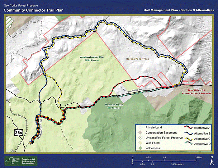
This map shows trail options to connect from from Route 28N east of Newcomb to the Gulf Brook Road.
Designation of the Gulf Brook Road: Motorized uses of the Gulf Brook Road are currently allowed as the land is privately owned. The lands are being logged and many leased camp members use this road to access their camps. These private motorized uses sunset in at the end of 2018. There are various proposals being advocated for the Gulf Brook Road. Some advocate for the entire area to be classified as Wilderness, which would close the road. Others call for the road to be maintained as part of a Wild Forest classification. Still others retain the road as the boundary between Wilderness to the north and Wild Forest to the south.
Any official action that involves the Gulf Brook Road while it is a private tractor, should be revisited when the lands eventually become Forest Preserve.
Community Connector Class II Snowmobile Trail Construction Violates the Adirondack Park State Land Master Plan
The State Land Master Plan (SLMP) defines a snowmobile trail as “a marked trail of essentially the same character as a foot trail” and mandates that it be “compatible with the wild forest character of an area.” A snowmobile trail “should be designed and located in a manner than will not adversely affect adjoining private landowners or the wild forest atmosphere….” These road-like community connector “trails” simply do not have the character of a foot trail and violates both the wild forest character and the wild forest atmosphere of the area. PROTECT has consistently stated that community connector class II snowmobile trails do not conform to these three standards.
There is no way this new community connector class II snowmobile “trail” bears any rational resemblance to something having the “character of a foot trail.” A community connector “trail” surface has been graded, leveled, and flattened by a multi-ton excavator. Extensive bench cuts are dug into side slopes that parallel the “trail” for long distances, protruding rocks are removed, extensive tree cutting is done, all understory vegetation is removed, and oversized bridges are built to support multi-ton groomers. In places bedrock may be fractured and chipped or gravel may be used to stabilize the trail surface. Bridges have been outfitted with plastic reflectors for night-time driving.
A “foot trail” is where people walk single file. They step over roots and rocks. The trail surface is uneven and follows the terrain. There are scarcely any stumps of cut trees. Vegetation on the side often encroaches, and the trail is canopy covered. Steppingstones and split logs are commonly used to pass over streams and wet areas. There are no reflectors.
PROTECT has identified that there are many other areas of the SLMP for Wild Forest areas that were expressly violated by the design and construction of community connector class II snowmobile trails, their intended use, and by grooming with large tracked (motor vehicle) groomers. These include:
• Basic Guideline 2 (Motor Vehicles, Motorized Equipment and Aircraft 6) states that public access accommodations should be “consistent with the wild forest character.” PROTECT does not believe that the new road-like community connector class II snowmobile trails are consistent with the wild forest character. The route’s width, bridges, reflectors, bench cuts, ledge cuts, use of gravel and straw, extensive surface alteration, tree removal, understory removal are all inconsistent with the “wild forest character” of Wild Forest areas.
• Basic Guideline 2 (Motor Vehicles, Motorized Equipment and Aircraft #8) states “All conforming structures and improvements will be designed and located so as to blend with the surrounding environment and require only minimal maintenance.” PROTECT does not believe that the new road-like community connector class II snowmobile trails meet the minimal maintenance test expressed here. DEC and the APA claim that the grooming of this trail is maintenance. PROTECT does not believe that numerous trips per week by a multi-ton tracked groomer on a major snowmobile route meets the “minimal maintenance” test.
• Basic Guideline 2 (Motor Vehicles, Motorized Equipment and Aircraft 9) states “All management and administrative actions and interior facilities in wild forest areas will be designed to emphasize the self-sufficiency of the user to assume a high degree of responsibility for environmentally sound use of such areas for his or her own health, safety and welfare.” Leaving aside concerns of snowmobile “environmentally sound use” with their mileage rates less than most SUVs, PROTECT questions the “self-sufficiency” of the users of these new road-like community connector class II snowmobile trails where the principal recreational use of snowmobiling can only be accomplished if the trail has been regularly groomed by a multi-ton tracked groomer.
Community connector trails widely violate the State Land Master Plan.
Submit a Public Comment Letter Today
The Adirondack Park Agency is accepting public comments until June 15th. Comments can be sent by mail, email or fax:
Kathy Regan
Deputy Director for Planning
NYS Adirondack Park Agency
P.O. Box 99
Ray Brook, NY 12977
Email: SLMP_Comments@apa.ny.gov
If submitting comment by email, please type Community Connector Trail Plan Amendment in the subject line of the email message.
Fax: 518-891-3938


