The Saranac Lake Wild Forest area is one of the most complicated Forest Preserve areas in the Adirondacks due to the wide variety of different public recreational opportunities and the popularity of the area. This part of the Forest Preserve includes the Saranac Lake chain of Lakes, which covers over 9,000 acres in an interlocking series of lakes and ponds. This area also includes hundreds of miles of hiking, mountainbiking and snowmobile trails and hundreds of campsites. The Saranac Lake Wild Forest is comprised of approximately 75,070 acres of Wild Forest lands and 19,000 acres of waterbodies. The Intensive Use boat launches that are included in this plan cover 33 acres.
The Adirondack Park Agency is holding a public hearing to approve a new Unit Management Plan (UMP) for the Saranac Lake Wild Forest Area. The public comment period closes on July 13, 2018. See information below for where and how to send in your public comments.
Send in an automatic letter to the Adirondack Park Agency by using the form below.
Click here for background information from the Department of Environmental Conservation on the new Saranac Lake Wild Forest UMP. The draft UMP can also be downloaded at this site.
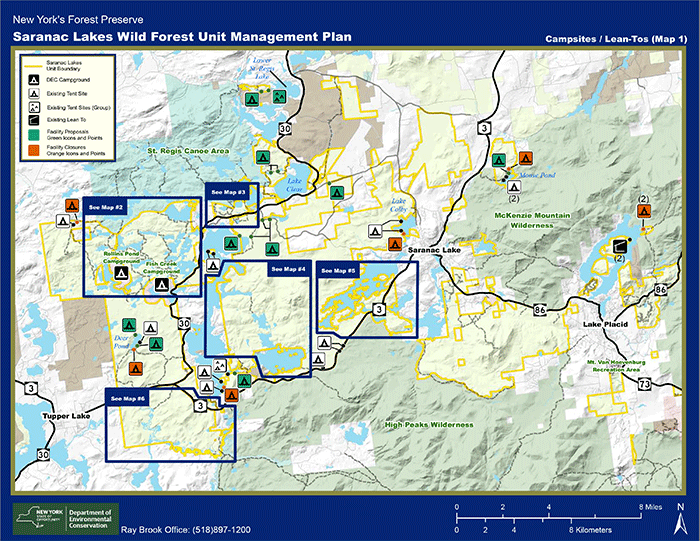
The map shows an overview of the 79,000-acre Saranac Lake Wild Forest area. This is one of the most complex and heavily used Forest Preserve areas in the Adirondack Park.
The Saranac Lake Wild Forest UMP includes many proposals for natural resource and public recreation management. Chief among these include locating new campsites, hiking trails, and mountainbike trails. The Department of Environmental Conservation has also proposed a new carrying capacity analysis to try and improve management of public recreational use on heavily used and popular hiking trails and well-trod campsites. This new UMP also proposes a new 7,400-acre “trailless area,” campsites for disabled individuals, and outlines plans for invasive species control.
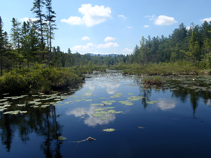
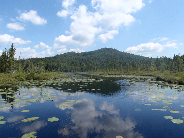
Top: A part of the navigable channel between Middle Saranac Lake and Weller Pond. Above: Beautiful Little Weller Pond. These extraordinary and picturesque small ponds would benefit from a motorless protection under the UMP.
Make Weller Pond and Little Weller Pond Motorless
Weller Pond, and Little Weller Pond, should be a motorless, quiet waters area that should be made off-limits to motorized watercraft, only accessible by non-motorized vessels. These ponds should be managed as a quiet and beautiful respite among the heavily used and extremely popular Saranac Lakes Chain.
The decision to make the Weller Ponds a motorless area should be made as part of the new Saranac Lakes Wild Forest Area Unit Management Plan, which the state released earlier this summer. While the state wants to maintain the status quo on Weller Pond, many public comments were submitted urging motorless management.
There are many reasons why the Weller Ponds should be a new motorless area:
1. The Weller Ponds would be the only motorless refuge on the popular and motorized Saranac Lakes Chain.
2. It would be easy to do. The State of New York owns the entire shoreline areas around both Weller Pond and Little Weller Pond. The state owns the lands around the navigable channel that connects these ponds to Middle Saranac Lake. The state has the authority to the close these ponds to motorized boat traffic; it simply needs the will to do so.
3. When we look across the Saranac Lakes Chain, from Lake Flower to the Saranac River to Upper Saranac Lake, the area totals over 9,000 acres of open waters. Weller Pond and Little Weller Pond are just 190 acres – just 2% of the waters of the Saranac Lakes Chain. Why can’t we set aside 2% of these waters as a motorless area?
4. Across the Adirondacks there are relatively few opportunities for motorless waters on large lakes and ponds. It’s important to note that most of the major Adirondack lakes are open to all manner of motorized watercraft. A report published by Protect the Adirondacks in 2013 The Myth of Quiet, Motor-free Waters in the Adirondack Park found that of the 100 largest lakes in the Adirondacks, from Lake Champlain to Beaver Lake western Adirondacks, 77 are open for all manner of motorized boating and floatplanes, 14 lakes are privately owned and provide no public access, and just 9 are motor-free. Boreas Ponds, number 95 among the Park’s biggest lakes, was recently purchased by state agencies and classified as Wilderness to create the 9th large public motorless waterbody. Of the nine motor-free lakes among the Park’s top 100, just six are relatively easy to access and motor-free. Just 17 of the biggest 200 lakes are easily accessible and motor-free. The demand is high for motor-free experiences, but the supply is low. The public deserves greater opportunities for motor-free waters across the Adirondack Park.
5. The administration of a motorless Weller Pond is manageable because there is only one entrance point – the 1,000-foot channel from Middle Saranac Lake. A sign stating that no motorboats are allowed could be placed at the entrance to the channel and a short distance into the channel. The DEC campsite reservation system could be changed to state that the lean-to and three campsites on Weller Pond are available only for non-motorized watercraft. DEC could also advertise the motorless state on its website.
Wild places grow fewer each year. The Adirondack Park offers great opportunities for hiking in wild places, where the longer one hikes the more remote the country one can access, but opportunities to do this by boat are limited. For many, canoe or kayak access is how they get to wild places and enjoy Wilderness. Greater opportunities are needed for motorless waters in the Adirondacks and Weller Pond is one such opportunity that must be seized.
![]()
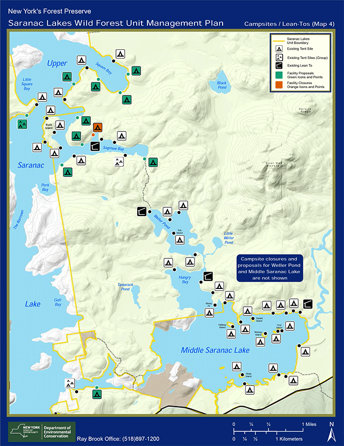
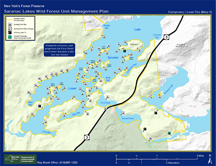
These three maps show proposed campsite areas. The top map shows proposed changes for a few campsite closures and new campsites on Follensby Clear Pond and Polliwog Pond. The middle maps shows proposed changes for Upper Saranac Lake and Middle Saranac Lake where a number of new campsites are being proposed. The map above shows the intensive grouping of campsites on Lower Saranac Lake that is part of the Saranac Lake Islands Campground. Though many of the campsites on Lower Saranac Lake violate the separation distances required under the State Land Master Plan, state agencies are planning to retain them while they study the issues.
Campsite plans violate the Adirondack Park State Land Master Plan
The Saranac Lake Wild Forest UMP fails to conform to the State Land Master Plan because dozens of campsites do not meet required separation distances. The three maps above show the intensive array of campsites on the many of the major lakes in this unit including, Lower Saranac Lake, Middle Saranac Lake, Upper Saranac Lake, Weller Pond, Follensby Clear Pond and Polliwog Pond to name just a few. No new campsite should be approved in the SLWF until all campsites are brought into compliance with the State Land Master Plan. Campsites that do not meet required separation distances should be closed.
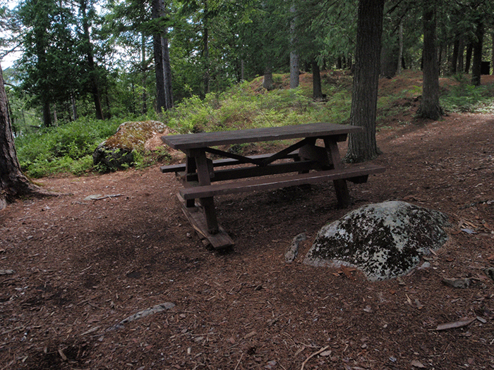
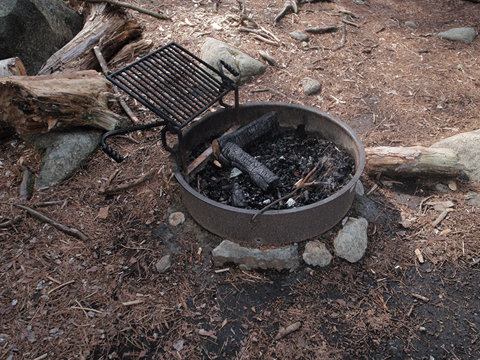
These two pictures show elements in a typical campsites on the Saranac Lake Chain where campsites are heavily used. Campsites are equipped with picnic tables and special fire rings in an effort to control impacts. Many of the campsites in the Saranac Lake Wild Forest area do not conform with the Adirondack Park State Land Master Plan.
Many required assessments, inventories and analyses for an evaluation of Forest Preserve conditions were not provided in the UMP
The Saranac Lake Wild Forest UMP fails to conform to the State Land Master Plan because it did not provide a number of required assessments, inventories and analyses about natural resources and recreational impacts detailed on SLMP pages 10-11. The State Land Master Plan requires analyses for areas experiencing overuse, those in in need of rehabilitation, analyses of existing and projected future use, among others. Pubic use data is out of date and incomplete. In some cases, the data cited in the UMP is 28 years old. In other cases, more than half the data is missing.
Required “carrying capacity” analysis for waterbodies was not undertaken
The Saranac Lake Wild Forest UMP fails to conform to the State Land Master Plan because it does not include a completed “carrying capacity” analysis for a number of waterbodies in this unit. The State Land Master Plan calls for UMPs to include carrying capacity analysis for waterbodies, but the Saranac Lake Wild Forest has failed to provide this analysis and information. Carrying capacity analysis is used to assess the optimum public recreational use on a waterbody so that both the natural resources and user experience are protected. Parking lots sizes that provide access to a waterbody and the number of campsites on a waterbody should be determined by carrying capacity analysis.
Proposed carrying capacity analysis framework is incomplete
The proposed carrying capacity analysis is skeletal and does not provide enough detailed information or an adequate schedule for implementation. The analysis fails to include adequate indicators to fully assess public impacts on trails or campsites. The proposed carrying capacity analysis in the Saranac Lake Wild Forest differs significantly from the carrying capacity analysis recently proposed in the Vanderwhacker Mountain Wild Forest and the High Peaks Wilderness area. While PROTECT congratulates the DEC on actually proposing a carrying capacity analysis, we have little confidence that the skeletal framework proposed in the Saranac Lake Wild Forest will be successful.
Submit a public comment today:
The public comment period is now closed.
Thank you very much for taking a stand to defend and protect the public, forever wild Forest Preserve!


