The Vanderwhacker Mountain Wild Forest UMP will establish public access to the Boreas Ponds
New trails will also access the High Peaks and Hudson River
State agencies have released a new draft amendment to the Unit Management Plan (UMP) for the Vanderwhacker Mountain Wild Forest area, which stretches across the central Adirondack Park, from North Creek to North Hudson. The Vanderwhacker Mountain Wild Forest Unit Management Plan (VMWFUMP) is an important plan because it not only contains a number of proposals for natural resource management on in Wild Forest areas of the Forest Preserve in the central Adirondacks, but it also sets public access to Boreas Ponds, which is part of the neighboring High Peaks Wilderness Area. This is an unusual situation on the Adirondack Forest Preserve where a Wilderness area is accessed through a Wild Forest Area. The two areas are side-by-side for miles.
Click here for background information on the Vanderwhacker Mountain Wild Forest UMP.
Click here for a copy of the new Vanderwhacker Mountain Wild Forest UMP.
Scroll down to the bottom of this web post and submit an automatic letter to state agencies.
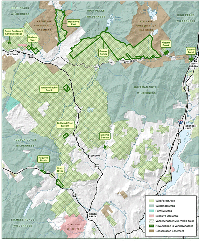
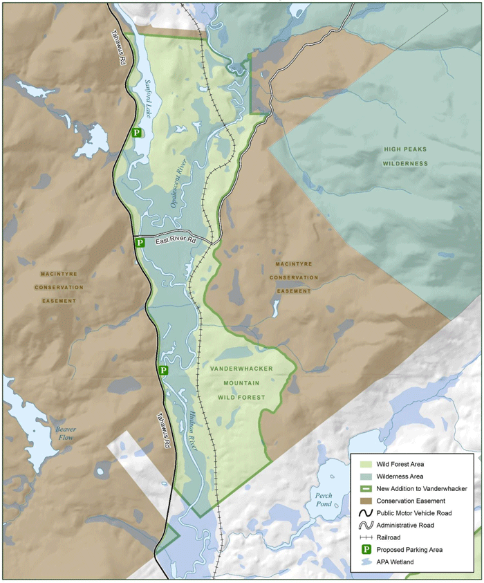
This map shows an overview of the Vanderwhacler Mountain Wild Forest area that stretches across the central Adirondack Park. The new areas recently acquired by the state that adjoin the Boreas Ponds and High Peaks Wilderness area are highlighted. The new tracts on the Hudson River are also shown in thick green boxes.
The new VMWFUMP proposes to utilize the Gulf Brook Road (see map above), which connects the Boreas Ponds and the Blue Ridge Highway, as a public road on the Forest Preserve. This will be a 3-season road, which is also proposed to operate as a snowmobile trail in the winter. The plan proposes tow new mountainbike trail “stacked loop” networks as well as nearly a dozen new hiking trails. Three of the new hiking trails are designed to provide new hiking access to the High Peaks Wilderness. The UMP amendment also provides public access for a new canoe route on the Hudson River south of the Tahawus Mine in Newcomb. The draft UMP also proposes a new “carrying capacity” analysis that state agencies will use to assess impacts on the natural resources and trails of the Forest Preserve for recreational use.
There are many controversial issues associated with this plan. PROTECT opposes some proposals, questions others, but supports a number of proposals. A detailed list follows of the major items involved in this plan.
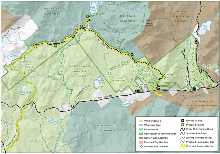
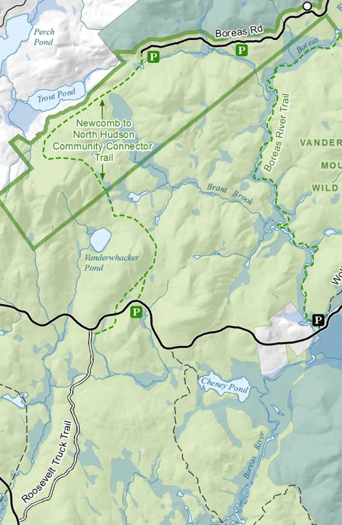
This map shows the variety of new public uses on the north end of the Vanderwhacker Mountain Wild Forest area and south side of the High Peaks Wilderness. State agencies are proposing a new snowmobile trail, new hiking trails, new parking areas and roads, two new mountainbike trail networks, and new campsites. PROTECT supports some of these proposed trails and opposes others.
Gulf Brook Road: PROTECT supports use of the Gulf Brook Road as a public motor vehicle road in a Wild Forest area on the Forest Preserve. This road will provide public access to the Boreas Ponds as well as to hiking trails that access the High Peaks Wilderness. We note that that the retention of this road was a centerpiece of the historic compromise that saw the Boreas Ponds classified as part of the High Peaks Wilderness. Though PROTECT supported this compromise as the best deal possible within the political constraints and realities of the Andrew Cuomo Administration, we note that road maintenance on the Gulf Brook Road will be extremely costly for state agencies and that this road in particular, given the grades of slopes and topography of the area, will require regular and extensive work every year. While we support use of this road now, we question to long-term ability of the state to adequately maintain this road as a safe and operational route for the public.
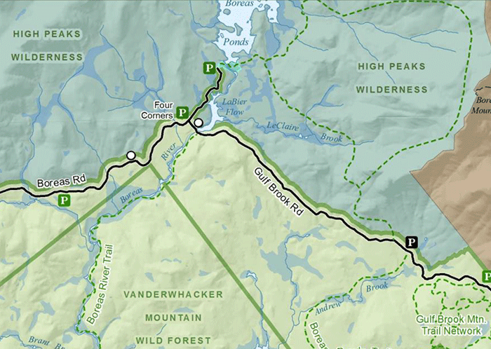
This map details the Wild Forest corridor that leads from the 4 Corners to near the Boreas Ponds. It also shows the proposed public parking areas near the Boreas Ponds, at the 4 Corners, and at Fly Brook (lower right side of map). There should be no public parking beyond the 4 Corners and near the Boreas Ponds except to accommodate special use for the disabled community under the CP-3 program.
Public parking to access the Boreas Ponds: Another controversial part of the new VMWFUMP is the plan for public parking on the Gulf Brook Road to access the Boreas Ponds. The state is proposing three parking areas: 1) Parking 500 feet from the Boreas Ponds for the disabled and general public. This small parking lots is proposed to hold motor vehicles for individuals who have obtained permits under the CP-3 program (Commissioner’s Policy for Motorized Access Program for Persons with Disabilities), which allows special access for individuals to use motor vehicles to access natural resource areas in the Forest Preserve. This special access is only for disabled people. While PROTECT has long been supportive of the CP-3 program, we find the use here to be troubling because the state is proposing to allow the non-disabled public also to access this parking lot near within 500 feet of Boreas Ponds. This undermines the CP-3 program. PROTECT strongly opposes any form of public parking by any means beyond CP-3 at this parking area 500 feet from the Boreas Ponds. 2) Parking at the 4 Corner 0.8 miles from Boreas Ponds. PROTECT supports this parking area. This general public should not be allowed any closer in a motor vehicle than 0.8 miles. 3) Public parking at Fly Brook 3 miles from the Boreas Ponds. PROTECT supports an additional small public parking lot proposed to located at Fly Brook. This parking area will accommodate hikers and the paddlers. We also support a parking lot at the entrance to the Gulf Brook Road, just off the Blue Ridge Highway.
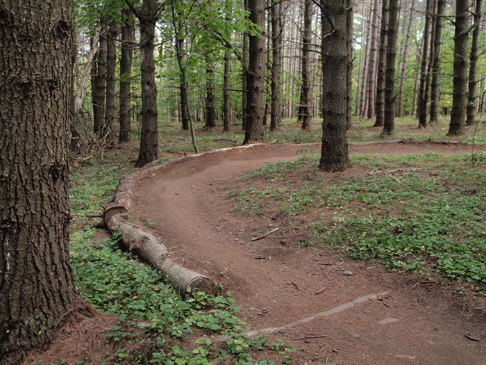
An example of a banked turn on a specially designed singletrack mountainbike trail in the Wilmington Wild Forest. The state is proposing to build two new mountainbike trails networks in the Vanderwhacker Mountain Wild Forest area.
Proposed Mountainbike Trail Networks: The UMP proposes two new mountainbike trail networks along the Blue Ridge Highway. These two new trail systems are what’s called “stacked loop” systems that offer challenging mountainbike trails. These are similar to the successful mountainbike trail systems in the Wilmington Wild Forest area at the Hardy Road and The Flume. These narrow single track trails systems will be specially designed with banked turns and narrow bridges. They are designed for one-way traffic.
The two proposed mountainbike trail networks in the VMWFUMP violate basic tenets of the recently finalized Management Guidance: Siting, Construction and Maintenance of Singletrack Bicycle Trails on Preserve Lands in the Adirondacks Park in several ways. The two networks do not seem to meet the criteria to make a successful trail network. The new Guidance lays out a four criteria for a new stacked loop mountainbike trail system. These criteria include “local support” and “location” as two important factors:
Local Support: The devotion of a local organization, municipality, or combination that is prepared to assist with trail maintenance and construction activities. Resources required for construction and maintenance of a stacked loop trail network requires this capacity.
Location: Stacked loop trail networks are most appropriate where Forest Preserve lands abut municipal lands or publically accessible private lands, generally within two miles of hamlet boundaries or one mile from Intensive Use areas.
The two mountainbike trail systems proposed in the VMWF fail to meet the two criteria above for either local support or location. These two systems are the fourth and fifth mountainbike, stacked looped trail networks proposed by the DEC. Two exist in the Wilmington Wild Forest area, one has been approved but not constructed in the Moose River Plains Wild Forest, and another has been proposed in the draft Saranac Lake Wild Forest UMP. The two Wilmington trails networks have proved very successful. They have local population centers in Lake Placid and Wilmington and attract riders that are both local and visitors to the area. They have helped spawn local businesses and anchor bike related events. These trails are supported by an active partnership with a local bike trails organization for trail maintenance. There is no similar local support network in the general North Hudson area. PROTECT does not see the necessary planning by the state to ensure that these trails will be successful. Given the vast expense to build these trail networks, more planning is necessary.
Besides failing to adhere to important criteria in the Guidance, the two mountainbike trails proposed in the VMWFUMP raise other questions. Does every Wild Forest area merit a mountainbike trail network? How many mountainbike trail network does the DEC envision in the Adirondacks? Mountanbike trail planning appears to be ad hoc and PROTECT urges state agencies to undertake comprehensive planning to determine where trails would be the most feasible and successful.
New Foot Trails: The VMWFUMP proposes a series of new foot trails. PROTECT supports all of them. We support the hiking trails planned for Ragged Mountain, the Boreas River, Wolf Pond, and Andrew Brook.
The new acquisitions opened up opportunities to vastly improve public access to the Hudson River. The new UMP proposes put-ins and take-outs that will make an excellent downriver canoe trip on this section of the Hudson River.
Canoe Put-ins and Take-outs on the Hudson River: The state’s acquisition of new lands along the Hudson River south of the Tahawus Mine opened up a terrific new canoe route. The VMWFUMP proposes new put-in and take-out locations that will vastly improve public access. PROTECT supports the proposals for public access to the Hudson River.
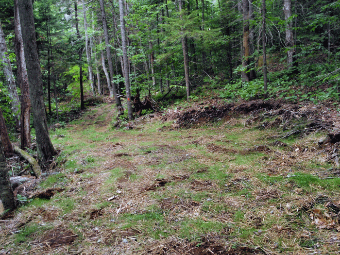
This picture shows a recently constructed and damaging class II community connector snowmobile trail built from the Santanoni Historic Area to the Harris Lake Intensive Use Area. This trail is much wider than the 9-12 feet allowable. Class II trails often see cutting down of over 1,000 trees per mile and extensive grading with heavy machinery to flatten the trail surface area into a road-like corridor.
New Class II Community Connector Snowmobile Trail: The VMWFUMP proposes building several miles of new class II community connector snowmobile trail to connect the Roosevelt Truck Trail with the Boreas Road and the Gulf Brook Road in order to make an east-west connection between the communities of North Hudson (at Exit 29 on the Northway) and Newcomb and Minerva. Protect the Adirondacks opposes all new class II community connector snowmobile trails because they violate the State Land Master Plan and the “forever wild” provision of Article 14 of the State Constitution. We recognize that the route that the state has selected requires the least amount of new class II trail corridor to be constructed, yet we believe that these road-like trails seriously damage the natural resources of the Forest Preserve. No other recreational use requires this level of terrain alteration.
The SLMP defines a snowmobile trail as “a marked trail of essentially the same character as a foot trail” and mandates that it be “compatible with the wild forest character of an area.” The SLMP goes on the state that a snowmobile trail “should be designed and located in a manner than will not adversely affect adjoining private landowners or the wild forest atmosphere…” There is no way that class II community connector snowmobile trails (see picture above) bear any rational resemblance to something having the “character of a foot trail.”
This map shows the area where a new class II community connector will be constructed to like the Roosevelt Truck Trail and the Boreas Road. While this trail inflicts less damage on the Forest Preserve than other trail proposals, PROTECT believes that class II trails violate the State Land Master Plan and State Constitution.
A class II community connector snowmobile trail surface has been graded, leveled, and flattened by a multi-ton tracked excavator. Extensive bench cuts are dug into the trail in many sections that run for a hundred yards. Protruding rocks are removed, roots are cut back, extensive tree cutting is undertaken, often at a rate of 1,000 trees per mile, all understory vegetation is removed, and oversized bridges are built to support multi-ton groomers. Ledge rock is fractured and split apart, trail surfaces are scarred by 6-wheel ATVs that leave deep wheel ruts, crushed gravel is often used to stabilize degraded areas, and the trail is studded with stumps. Extensive areas of open canopy are opened above the class II trail and the trail surface is dominated by grassfields incongruent with the surrounding forest. Bridges are outfitted with plastic reflectors for night-time driving. Trail signs resemble road traffic signs.
A “foot trail” is where people walk single file. Foot trails are narrow and built to go over and in between roots and rocks and around trees. Foot trail surfaces are uneven and follows the terrain. Few trees are cut down for foot trails and there are scarcely any stumps of cut trees. Vegetation on the trail side encroaches, and the trail is canopy covered. Steppingstones and split logs are commonly used to pass over streams and wet areas. There are no reflectors and grass is scarce.
For all practical purposes, class II community connector trails resemble roads much more than foot trails. PROTECT opposes new class II community connector snowmobile trails in the VMWF area.
Carrying Capacity Analysis: The new VMWFUMP proposes a new system to assess the overall carrying capacity of the area. The goal of state agencies it to implement a new program that will allow them to assess establish “acceptable conditions” for the natural resources and recreational facilities in this unit. They will use this information to determine the existing relationship between existing conditions on the ground and those that they desire. They will then prescribe different management actions to move towards the desired conditions as well as set up some form of monitoring program to make sure all these objectives are going to be met. This is a new approach by the Department of Environmental Conservation and in many ways the Vanderwhacker Mountain Wild Forest area is the test case.
PROTECT supports the state’s commitment to developing and implementing carrying capacity analysis. We will work with state agencies to share information and help to develop a comprehensive new program that will improve the management of the Forest Preserve by protecting both natural resources and the user experience.
Submit your public comments today.
Public comment are due by Wednesday June 27, 2018. Send to:
The public comment period is now closed.


