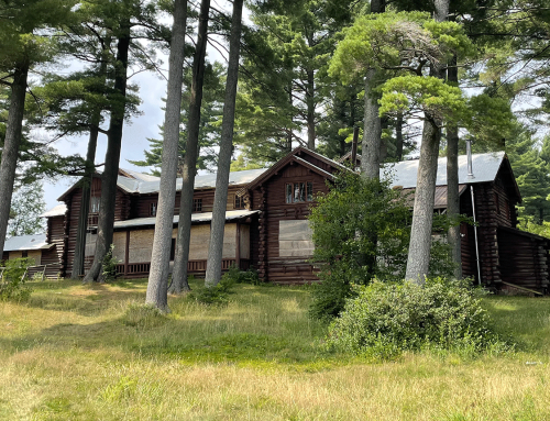
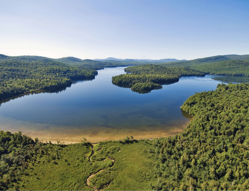
The Department of Environmental Conservation (DEC) has released a draft plan for amendments to the Unit Management Plans (UMPs) for the Forest Preserve units of Vanderwhacker Mountain Wild Forest, the Camp Santanoni Historic Area, and the Lake Harris Public Campground (an Intensive Use Area). These amendments will also impact the Hudson River Hyslop Conservation Easement and the Blue Ridge Road Conservation Easement lands (both part of the former Nature Conservancy-Finch Paper lands).
The DEC is taking public comments on this UMP until July 25, 2014. See the draft UMP Amendments here.
The DEC’s plan amends UMPs for the Vanderwhacker Mountain Wild Forest (UMP approved in 2005), the Camp Santanoni Historic Area (UMP approved in 2000), and the Lake Harris Public Campground (UMP approved in 1995). The DEC states that new Recreation Management Plans (RMPs) will be developed for associated conservation easement lands in the future.
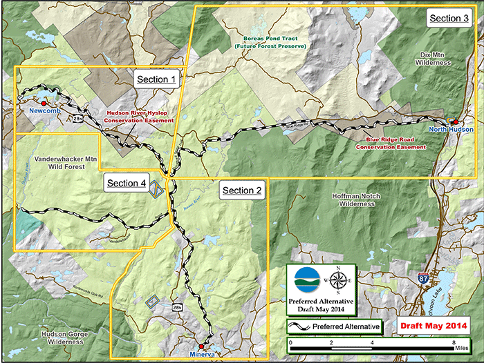
This map from the DEC shows proposed recreation routes — mainly snowmobile trails — that involve various units of the Forest Preserve in the central Adirondacks.
The DEC refers to the proposed amendments for these three Forest Preserve areas as a multiple-use plan. The DEC states “The primary purpose of this Multipleâ€Use Community Connector Trail Plan (Plan) and Draft Environmental Impact Statement (DEIS) is to analyze alternatives and select a preferred location for proposed community connector multipleâ€use trails between the towns of Newcomb, Minerva and North Hudson.” Overwhelmingly, these amendments seek to expand snowmobile trails in the central Adirondacks.
Protect sees many issues involved in these proposals.
Polaris Bridge Should be Removed: The DEC proposes to retain the Polaris bridge (Iron bridge) over the Hudson River. The retention of this bridge violates the Wild, Scenic and Recreational Rivers Act (Rivers Act), which forbids public recreational motor vehicle use with the Scenic River corridor. This bridge exists in a Scenic River corridor where public motor vehicle use is not allowed. The bridge violates trail width standards in the Rivers Act regulations, which define a trail as 4 feet in width.
New Snowmobile Trails through the Heart of the Vanderwhacker Mountain Wild Forest Area: A big issue is the DEC’s proposal to route new snowmobile trails through the heart of the Vanderwhacker Wild Forest area. PROTECT opposes the new trail west of Vanderwhacker Mountain. This area includes extensive wetlands and is a trailless, wild part of this unit. The snowmobile trail that connects to Hudson River and the Polaris Bridge violates the Rivers Act.
These trails will necessitate a great deal of tree cutting and be environmentally destructive. PROTECT opposes to creation of these trails.
See a map below that shows these two proposed new trails.
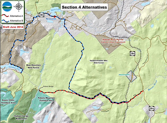
The DEC proposes two new snowmobile trails through wild areas in the central parts of the Vanderwhacker Wild Forest. These new routes will be used for snowmobiles in the winter and mountain biking in other seasons.
Minerva to Newcomb Snowmobile Trail: A Minerva to Newcomb snowmobile trail connection has long been elusive for DEC planners and local government officials. Famously, the 2005 Vanderwhacker Mountain Wild Forest UMP included eight options for this trail and offered none as a preferred route. There is simply no good way to connect Newcomb to Minerva. Real obstacles exist, such as crossings for the Hudson and Boreas rivers, Vanderwacker Mountain, and private landowners who have no interest in a major snowmobile trail in their back yards. As as result DEC has built pieces of snowmobile trails here and there in hopes that one day they will be connected.
The DEC has offered two proposals in the UMP amendments now. Both are bad. The first, as described above, seeks a trail that crosses the Hudson River by utilizing the Polaris bridge, which violates the Rivers Act, and then cuts through the interior of the Vanderwhacker Mountain Wild Forest area along two routes; one to the north west of Vanderwhacker Mountain, the other running south of Vanderwhacker Mountain to Route 28N.
A second options seeks to route a snowmobile trail north of Newcomb through Lake Harris and then largely alongside Route 28N. The trail either utilizes the Upper Hudson Railroad corridor or remains roadside to Minerva.
See two maps below that detail this route.
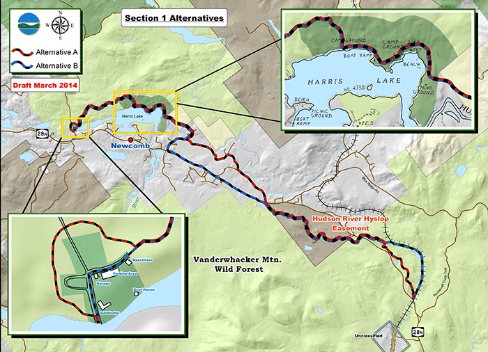
DEC’s proposal to build a snowmobile trail that links Newcomb to Minerva through Harris Lake and the Route 28N corridor.
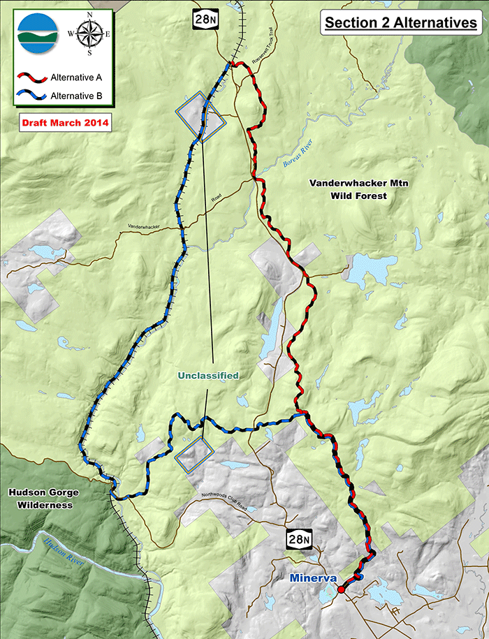
DEC’s proposal to either run the Newcomb to Minerva snowmobile trail on part of the Upper Hudson Railroad corridor or alongside Route 28N. Both of these proposed routes have problems.
The reality is that even the roadside route is plagued with very real problems from challenging terrain, such as cliffs, wetlands, and private landowners who have not granted permission for snowmobile trails. Many areas on Route 28N are to narrow for snowmobile riding on the roadside. There is also a major challenge for crossing the Boreas River on Route 28N. A snowmobile would be very expensive and the DEC has not provided any public statement from the Department of Transportation about its support for attaching a snowmobile bridge to its current bridge. Though less environmentally destructive than the proposed routes through the heart of the Vanderwhacker Mountain Wild Forest area, the roadside option has serious problems and challenges.
Many also remark that the snow conditions in Minerva are not conducive to a strong snowmobiling season. Snowfall in the eastern Adirondacks is much less than the western Adirondacks.
It may very well be the case that since there is no good way to connect Newcomb to Minerva. The DEC should not advance any plan or begin any work until 100% of the proposed route is approved and secured for the long-term. It makes no sense to build part of a trail system.
The other option is to utilize the Upper Hudson River Railroad corridor along the Boreas River and parts of the Northwoods Club Road. This route too has problems with poor snowmobiling conditions on a railroad track and forging an agreement with the railroad operator.
Newcomb to North Hudson Snowmobile Trail: The DEC also seeks to connect Newcomb and North Hudson with a snowmobile trail. Like the trail to Minerva, this east-west connection has long been a desire of local communities. The purchase of the Nature Conservancy-Finch Paper Forest Preserve and conservation easement lands along the Blue Ridge Highway create the possibility of making this connection. The DEC provides two options. Both connect to Newcomb through the Roosevelt Truck trail and conservation easement lands. PROTECT finds the route that utilizes the Golf Brook Road from Newcomb to the Blue Ridge Road, where it can connect with easement lands south of the road, to be the better route. See this proposed route below.
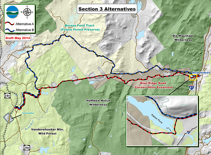
DEC options for a Newcomb to North Hudson snowmobile trail connection. PROTECT supports a route that utilizes the existing Golf Brook Road and conservation easement lands south of the Blue Ridge Road.
Though the Golf Brook Road is mostly within the Boreas Pond tract, and not yet owned by the state, it is under contract and will come into state ownership in the near future. DEC should hold off on final plans for this route until all lands have been acquired. It makes no sense to build a trail when a better route may very well become a possibility in the near future.
In North Hudson, at the far east end of the proposed connection, the DEC proposes the construction of a bridge near Palmer Pond that will serve two purposes: 1) to provide administrative motor vehicle access to the south side of the dam that impounds Palmer Pond, and 2) to provide a crossing for the Newcombâ€toâ€North Hudson community connector trail that is also proposed in this Plan. These activities do not appear objectionable.
Write a Public Comment Today to the Department of Environmental Conservation
Letters must be received at the DEC office by July 25, 2014:
Josh Clague, Natural Resources Planner
625 Broadway, 5th Floor
Albany, NY 12233-4254
Thank you for taking a stand in defense of the Forest Preserve.


