The Adirondack Park Agency is accepting public comments on its proposed land classifications for 5,800 acres of newly purchased Forest Preserve lands in the Adirondack Park.
The Adirondack Park Agency (APA) is seeking public comment on its proposed 2023 Forest Preserve classifications package for over two dozen parcels of Forest Preserve in the Adirondack Park. This classification package includes 25 parcels (19 acquisitions, 6 map corrections) of newly purchased lands that total over 5,500 acres and 11 proposed reclassifications of around 250 acres.
Protect the Adirondacks generally supports the APA’s proposed classifications and support their adoption. A few of the proposed classifications should be changed, to strengthen Forest Preserve protections, and we urge the APA to make those changes before the final 2023 classifications package are adopted.
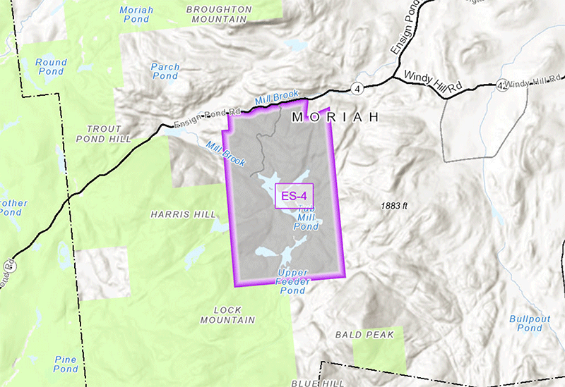
This 1180-acre parcel in the Hammond Pond Wild Forest is an example of the overall classification package. This new tract around Tub Mill Pond off of the Ensign Pond Road is recommended for Wild Forest classification.
Public comments are needed by the close of business on November 27!
Click here to review the Forest Preserve classifications package through an interactive map.
Click here for background information from a Powerpoint presentation by the APA on the 2023 Forest Preserve classification package. Click here for additional background information and maps of each parcel.
The classification package include 19 parcels for new classification, 11 reclassifications, and 6 classifications involving map corrections. We applaud APA for classifying newly acquired Forest Preserve lands and for correcting the classifications of existing State lands, including the 208.5 acre SUNY Cortland parcel in Long Lake used for Camp Pine Knot on Raquette Lake. We are pleased to see the designation of four of the parcels, totaling 196.8 acres, as Wilderness lands, including the newly acquired 17.9 acre parcel on Thirteenth Lake in Johnsburg.
While Protect the Adirondacks supports the majority of the proposed classifications as Wild Forest, State Administrative, and Intensive Use, we do have concerns about a few of the parcels, as described below.
Golden Beach (Parcel HA-6-d)
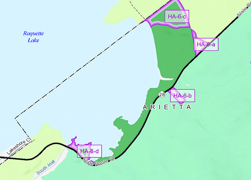
On this set of classifications, we generally agree, but urge that the reclassification to Wild Forest from Intensive Use should be moved east along Route 28.
We support reclassification of 31.1 acres from Intensive Use to Wild Forest as shown in Parcels HA-6-c and HA-6-d. In addition, APA should reclassify to Wild Forest all of the lands south of campsites 207 & 208 in the Golden Beach campground. These lakeshore lands are not appropriate for development and should be added to the adjacent Parcel HA-6-d to become part of the Sargent Pond Wild Forest. We suggest that the boundary for the Wild Forest lands start 150 feet from the edge of the campground’s southernmost campsites.
Marion River (Parcel HA-1 and Parcel HA-2)
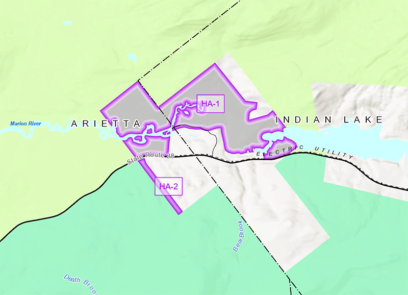
We support these two classification proposals. We support the Wild Forest classification for the Marion River Carry parcel. We also support the sliver of land on the south side of Route 28 being classified as part of the Blue Ridge Wilderness Area.
We support classification of the Marion River Parcel HA-2 to Wilderness since it adjoins the Blue Ridge Wilderness. We also support classification of the Marion River HA-1 parcel as Wild Forest. The parcel has significant wetlands and contains the Marion River, an important water connection between Raquette Lake and Blue Mountain Lake. The Marion River is classified Scenic pursuant to the State’s Wild Scenic and Recreational Rivers Act. The parcel provides scenic recreation for canoeists, but, at least at this time, due to prior and current human development on and near the parcel, it does not offer the kinds of solitude and opportunities for remote water-oriented recreation that might make it appropriate for classification as a Wilderness or Canoe area.
Crane Mountain/Huckleberry Mountain (WR-2)
Protect the Adirondacks respectfully suggests that APA consider a potential Wilderness classification for the Forest Preserve lands comprising Crane Mountain (Town of Johnsburg), which now includes the adjoining 1,276.2-acre Huckleberry Mountain parcel WR-2 that is part of this classification package. The Crane Mountain lands contain rugged, wilderness territory that meet the Adirondack Park State Land Master Plan’s definition of Wilderness:
an area where the earth and its community of life are untrammeled by man–where man himself is a visitor who does not remain. A wilderness area is further defined to mean an area of state land or water having a primeval character, without significant improvement or permanent human habitation, which is protected and managed so as to preserve, enhance and restore, where necessary, its natural conditions, and which (1) generally appears to have been affected primarily by the forces of nature, with the imprint of man’s work substantially unnoticeable; (2) has outstanding opportunities for solitude or a primitive and unconfined type of recreation; (3) has at least ten thousand acres of contiguous land and water or is of sufficient size and character as to make practicable its preservation and use in an unimpaired condition; and (4) may also contain ecological, geological or other features of scientific, educational, scenic or historical value. (page 22)
While the Crane Mountain/Huckleberry Mountain Forest Preserve lands are currently less than ten thousand acres in size, they could effectively be managed as wilderness as the “Crane Mountain Wilderness Area” covering an area of around 3,000 acres.
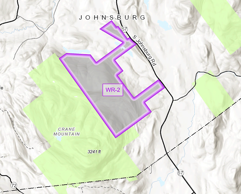
We urge the APA to investigate a Wilderness classification of the new Huckleberry Mountain tracts in combination with the existing Crane Mountain tract. Together this could be a 3,000+ acre Crane Mountain Wilderness Area.
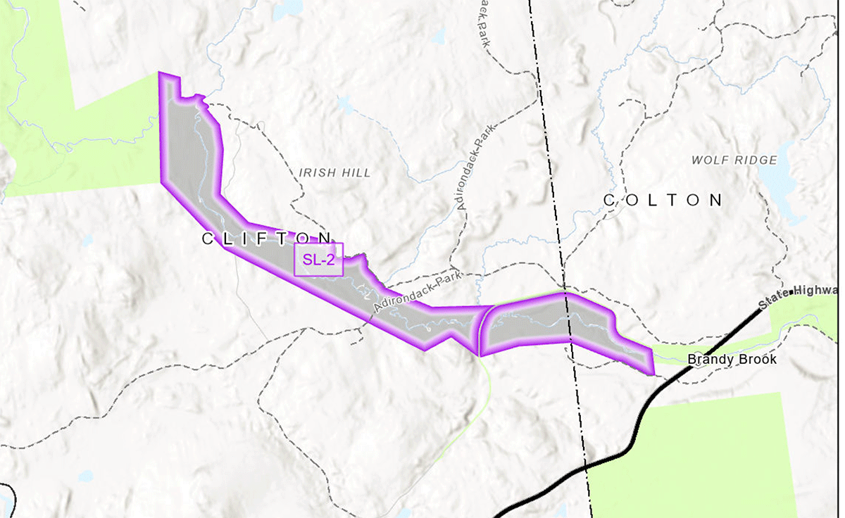
South Branch of the Grass River
A new acquisition of nearly 1,000 acres along the South Branch of Grass River ensures the permanent protection of this wild river corridor. The proposed Wild Forest classification connects existing Forest Preserve areas along the river.
This proposed classification will ensure a continuous Wild Forest protected river corridor on both sides of the South Branch of the Grass River.
Submit Your Public Comment Today
Public comments are due by the close of business on November 27th (the Monday after Thanksgiving).
Comments are now closed.
Click here to read public comments submitted by Protect the Adirondacks.


