This is the fourth article in a series that looks at three possible constitutional amendments to Article 14, Section 1 that are being debated in 2020. This article looks at the issue of utilizing Forest Preserve lands around Cathead Mountain, in the south edge of the Silver Lake Wilderness area, to locate a new emergency communications tower, similar to such towers on Blue Mountain and East Mountain.
The legislative calendar makes action on a proposed amendment to the State Constitution advantageous in 2020. Two separately elected Legislatures must act on any proposal before it goes to the electorate. If First Passage is approved by the Legislature in 2020, then Second Passage could be approved in 2021, followed by a vote by the People of the State of New York in November 2021. If First Passage is delayed until 2021, then Second Passage and a vote of the People will not be available until 2023 at the earliest.
This article is the fourth of five that looks at Article 14 amendments in general, the three amendments currently being organized, and the hangover from the NYCO amendment in 2013. The first article outlined the history of Article 14 amendments in recent decades. The second article in this series will focus on the Mt. Van Hoevenberg Olympic Winter Sports Complex managed by the Olympic Regional Development Authority. The third article looked at the issues involved in moving Camp Gabriels off of the Forest Preserve. All of these amendments are in the early stages of development. A fifth will look at the passage of the NYCO amendment, which raised serious questions about public accountability.
Hamilton County’s Quest
Hamilton County has been trying to expand its emergency communications network for years. The county has dead spots for not only cell service, but for its emergency communications system too. That said I’m routinely amazed at the places I get cell service in remote locations in the county and in many places up high. The county’s preference is to expand its network of line-of-sight towers that are powered by utility lines, with emergency backups, and are accessible by motor vehicle for servicing. The south end of Hamilton County has limited service for police and EMT communications.
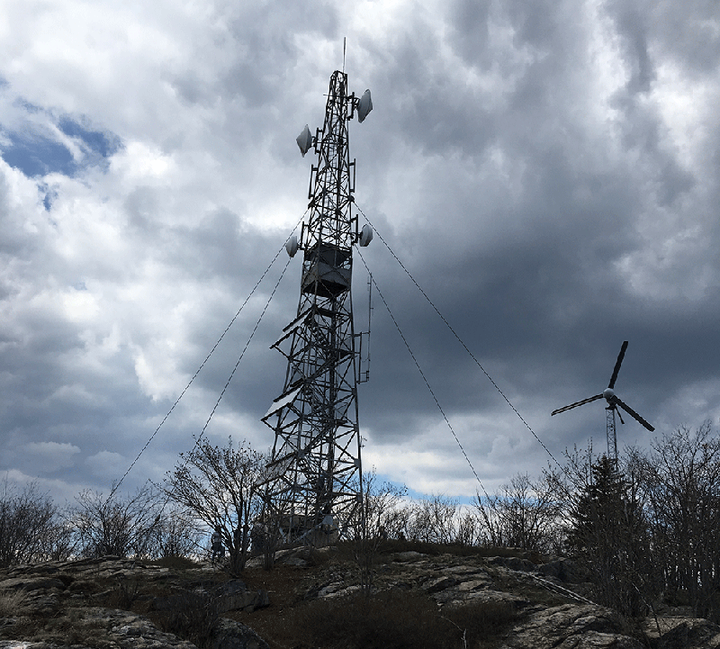
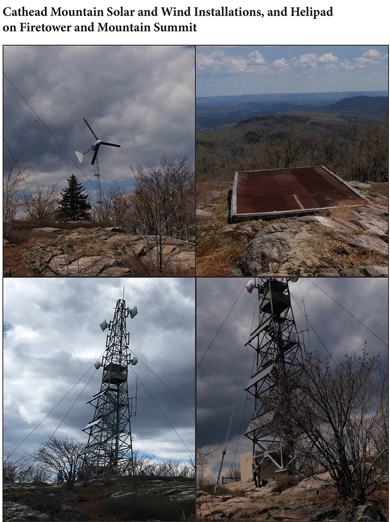
On the summit of Cathead Mountain there is a firetower long abandoned by the State, but which has since been used by the State Police as a communications tower powered by a solar array affixed to the firetower and windmill. This installation is serviced by personnel who access Cathead Mountain via a helicopter, and there is a landing pad built on the summit, or on foot, hiking the roughly 1.5 miles.
Hamilton County has seized on Cathead Mountain as the best location to build a new emergency communications tower for a number of reasons, including existing facilities, it’s on private lands, will service the area in greatest need, and it is at the elevation to line up with other towers in in the county. All of that said, the problem facing construction of a new emergency communications tower on Cathead Mountain is that while it’s private land it’s located in an inholding in the Forest Preserve devoid of motorized access.
Protect the Adirondacks has a number of concerns about this effort. First, Hamilton County has stated that in order to build an emergency communications tower similar to those in other locations, such as Blue Mountain and East Mountain, it needs a reliable power supply that is larger than what is currently provided on Cathead Mountain through solar and wind. A new installation on Cathead Mountain requires a utility line, the County tells us. Additionally, the County claims that it would need motor vehicle access to mountaintop facilities for regular servicing and emergencies.
If there are sites other than Cathead Mountain that are viable for emergency communications in the south end of the county, then an amendment is unnecessary. If motor vehicle access is not needed to the summit of Cathead Mountain, then an amendment is unnecessary. If an enhanced solar array can power the new installation, and can be serviced by personnel on foot or by helicopter, then an amendment is unnecessary. Our comments below are made on the assumption that Hamilton County has done its due diligence on these matters and that there are no other viable locations and that a largescale emergency communications installation on Cathead Mountain truly requires motor vehicle access. For now, we will take the County’s word on these issues.
Second, given the stated importance of this new communications tower to Hamilton County, it’s critical that Hamilton County release a formal proposal. This issue has been around for years. We participated in a field trip to the site in 2018. We participated in meetings held by legislators on this matter in 2018 and 2019. The Legislature should not act on this matter without the County providing complete engineering studies to back up its claims. Any such studies should include a full examination of alternative sites, tower sizes, power sources, and means of access. Protection of the Forest Preserve requires no less.
The Lay of the Land
Cathead Mountain is located in Benson in southern Hamilton County, and its southern flank is in the Forest Preserve. However, the summit is privately owned and is part of an inholding within the Forest Preserve. The public lands that surround Cathead Mountain are classified as either Wilderness, part of the Silver Lake Wilderness, or as Primitive, classified as the Cathead Mountain Primitive Area. Cathead Mountain is part of an 820-acre inholding in the Forest Preserve owned by the Hatch Brook Club. The Hatch Brook Club also owns lands outside of the inholding at the end of North Road in Benson that total 164.2 acres. These lands border the Forest Preserve directly south of the inholding.
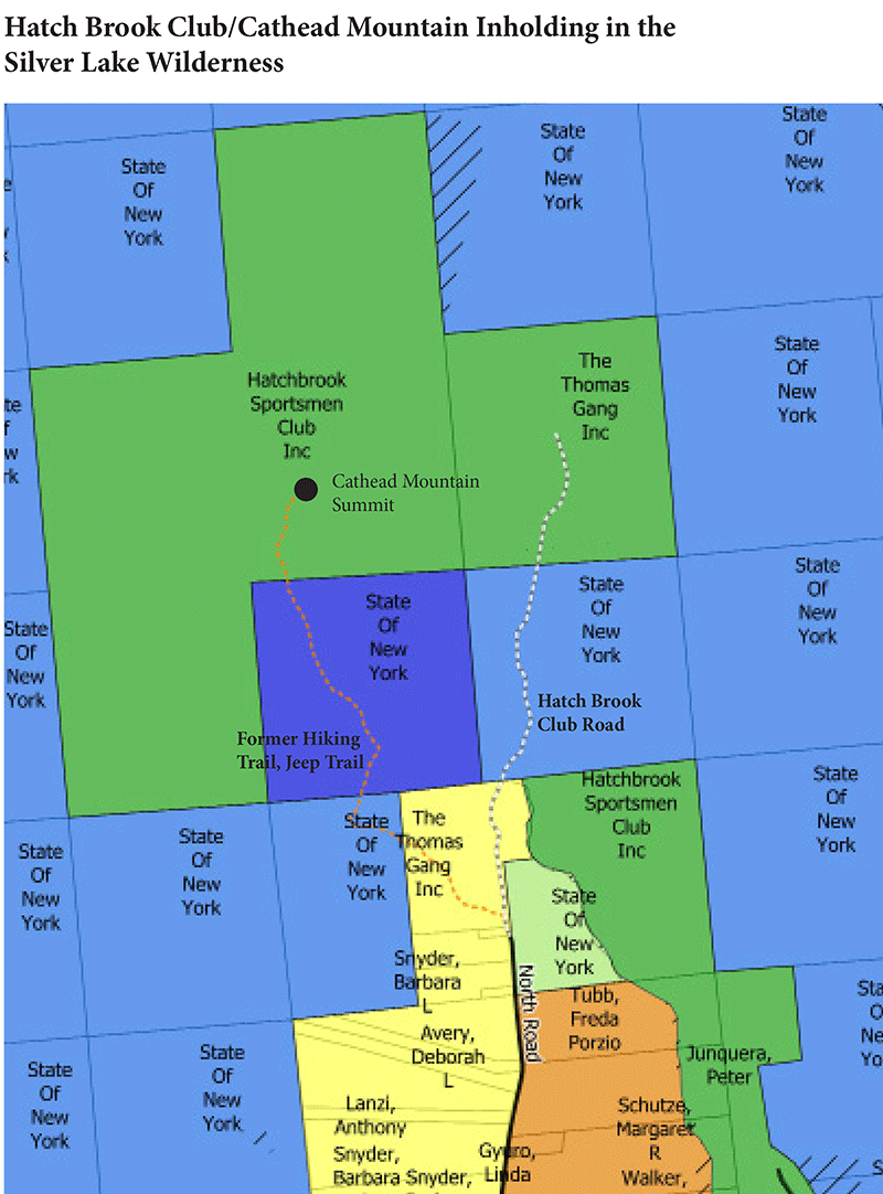
The Hatch Brook Club accesses its lands via a gated private road called Hatch Brook Road that starts at the end of North Road in Benson. It leads to a large parking area/logging landing, then continues through the Forest Preserve along Hatch Brook to the inholding, but is gated and clearly marked as Forest Preserve.
The Hatch Brook Club does not have any easement across the Forest Preserve. Its predecessor tried legal action to gain an easement across the Forest Preserve for access to the inholding, but the courts rejected this claim. Thomas Gang, Inc. v. State of New York, 19 A.D.3d 861 (3d Dept. 2005). The Hatch Brook Club members hike the 0.536-mile Hatch Brook Road through the Forest Preserve to their camp. At times they use a horse and wagon to haul supplies, through the Forest Preserve. The Hatch Brook Club members enjoy the same rights, no greater and no less than any other person, to use the Forest Preserve according to the rules in the State Land Master Plan and the Silver Lake Wilderness Unit Management Plan.
The State of New York had built a firetower and a ranger/observer’s cabin on the private land at the summit during the decades that towers were used for forest fire control in the 20th century. The use of the firetower was discontinued by DEC, but it has since been used by the State Police as a communications tower. This facility is powered by a solar array affixed to the fire tower, and by a windmill. This installation is serviced by personnel who access Cathead Mountain via helicopter, using a landing pad built on the mountain, or on foot, hiking the roughly 1.5 miles.
For many years, the Club allowed public access to the Cathead Mountain. The hike, while very steep in places, provides a big reward with a panoramic view, which is perhaps the grandest in the southern Adirondacks. Public access was shut off by the Club during previous legal fights and has not been re-opened. Today, the mountaintop is closed to the public.
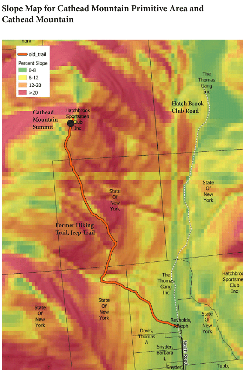
The hiking trail route up Cathead Mountain starts on private lands owned by the Club just after the gate at the end of North Road. The trail follows an old logging road on Club lands for over 0.5 miles before intersecting with Forest Preserve lands classified as Wilderness and Primitive. The route on the Forest Preserve runs 0.834 miles and contains much of the elevation gain in very steep sections. This route partially follows what appears to be an old jeep trail of some kind before reaching private club lands for the final 0.2 miles to reach the summit of Cathead Mountain.
An Administrative Fix Is Not Permissible
Other groups are calling for an “administrative fix” of Forest Preserve management that would facilitate construction of Hamilton County’s communication tower on Cathead Mountain and not require an Article 14 amendment. The framers of Article 14 were deliberate in their intention to provide the strongest protections possible for the public Forest Preserve. To accomplish this, they protected the Forest Preserve in the State Constitution, which required that major decisions about the use of these lands were to be made only through a constitutional amendment. They were clear that major decisions on the people’s land were not to be made unilaterally by the Governor, nor made administratively by state agencies, nor made by actions of the State Legislature. The People should make all major decisions on the People’s lands. This core principle of the framers of Article 14 goes to the very essence of any discussion of an “administrative fix” for Cathead Mountain.
Protect the Adirondacks has been in court since 2013 defending Article 14, Section 1, the forever wild provision of the State Constitution, against violations by the Cuomo Administration and state administrative agencies to build a network of wide, road-like class II community connector snowmobile trails in the Forest Preserve that required tree cutting of upwards of 1,000 trees per mile. We’re now at the Court of Appeals where we are defending a 4-1 decision in our favor from the Appellate Division, Third Department.
A proposal has been made by another organization to somehow utilize the current old hiking trail/jeep trail on Club lands and Forest Preserve lands to provide access to the summit of Cathead Mountain. Under this theory, the Adirondack Park Agency (APA) and Department of Environmental Conservation (DEC) would reclassify a section of Wilderness, that includes a portion of this route, to Primitive and add these lands to the Cathead Mountain Primitive Area. The Adirondack Park State Land Master Plan would then be amended to create an administrative road, that would allow motor vehicle access to authorized personnel, which status the State would presumably confer on Hamilton County to service an installation on the summit of Cathead Mountain.
Construction of a road on the Forest Preserve over the length of 0.834 miles is a major decision. Protect the Adirondacks believes that such a decision could only be made by a vote of the People of the State of New York and not by administrative agencies. Beyond this concern, there are three other significant problems with an administrative fix.
First, the fix would require weakening of the Adirondack Park State Land Master Plan. We note that the Cuomo Administration weakened the Master Plan in 2016 to allow motor vehicles and bicycles on administrative roads in the Essex Chain Lakes Primitive Area. Until that point, Primitive lands had been managed as Wilderness. This was the first time in the 48 year history of the Master Plan that the APA had weakened it rather than strengthened it. While we’re confident that the DEC and APA would undertake new actions to further weaken the State Land Master Plan, this action would be undercut by the realities on the ground, both constitutional and topographical.
Second, Protect the Adirondacks believes that an administrative fix has a constitutional problem. We counted the 378 trees along the 0.834-mile distance of the former hiking trail/jeep trail to Cathead Mountain on the Forest Preserve that would have to be cleared to use this route. This would be a level of tree cutting that exceeds the acceptable historic legal standards — that cutting should not exceed a “material degree” or a “substantial extent” during Forest Preserve management. Note that this figure is just the trees within the corridor of the old hiking/jeep trail. Given topographic problems due to many exceedingly steep slopes, which we will address next, it would be impossible to build a motor vehicle road using the existing route. A different route, which utilizes many switchbacks, would be necessary for motor vehicle use. The tree cutting involved in a new route would be immense, far beyond our count of 378 trees within the existing corridor, which is already constitutionally problematic.
Third, the use of the old hiking trail/jeep trail as an access road is not viable due to severe slope constraints. Most of this route scales slopes greater than 12%, and often greater than 20%. We note that there has been criticism of old and degraded hiking trails in the High Peaks Wilderness that traverse slopes of 12% or greater. The amount of terrain alteration needed to build a motor vehicle road with adequate stormwater controls on this route would be immense. Even if the existing route was refurbished and utilized just for all terrain vehicles (ATVs) to access Cathead Mountain, and not for standard pickup trucks and similar vehicles, we do not think that the tree cutting would conform with historic legally allowable levels.
Protect the Adirondacks does not believe that the State of New York should build any more roads for motor vehicles on the Forest Preserve. We certainly do not believe that roads should be built on 12% and 20% grades. If an access road is needed for motor vehicles to reach an installation on Cathead Mountain, this should be done on private lands, and not on the Forest Preserve.
It should also be noted that the use of the old jeep trail/hiking trail would also need the permission of the private landowner. While the private landowner, the Hatch Brook Club, has stated its willingness to explore a land swap with the state, we have not heard that the Club is willing to permit Hamilton County to use its land without dealing with its access issues.
Another option in the administrative fix quiver is to use Hatch Brook Road, which runs 0.53-miles along Hatch Brook through a tract of the Silver Lake Wilderness. As mentioned previously, it is currently utilized by Club members on foot or with horse-and-wagon to access their 820-acre inholding. Our field assessment on Hatch Brook Road counted a significant number of trees that would need to be cut to upgrade that road for motor vehicle use. Even more problematic, in our estimation, is that the road crosses four permanent and intermittent streams and runs just a few feet off of Hatch Brook for considerable distances. No modern, well-designed administrative road could be built within a few feet of a major stream. Any re-routing of this road would necessitate heavy tree cutting well beyond the acceptable historic legal standards not to exceed a “material degree” or a “substantial extent” during Forest Preserve management.
The last issue is a power line that Hamilton County claims it needs to power the new tower. Here, there is no legal way to place a new power line across the Forest Preserve. This is a long-settled issue. In Attorney General Opinion 96-F2, Attorney General Dennis Vacco stated, “Any development in the forest preserve which is not consistent with Article XIV, § 1 must be specifically authorized by constitutional amendment.” Vacco expressly stated that use of a TRP was not valid for a new power line. The Opinion also states, “We are constrained by the absolute language of the constitutional provision that land in the forest preserve shall not be leased, sold or exchanged, or be taken by any public or private corporation” and concludes that the granting of a power line on the Forest Preserve is for a special interest.
For all of the foregoing reasons, Protect the Adirondacks does not believe that there is any kind of viable administrative remedy or “fix” to solve the challenge of building an emergency communications installation on the summit of Cathead Mountain.
Amending Article 14 for a Cathead Mountain Tower
Cathead Mountain is the most complicated of the three possible Article 14 amendments under discussion in 2020. It involves many different stakeholders to be perfected and would likely need to include the DEC to draft conservation easements and binding agreements with both the associated private landowner and Hamilton County.
The Problem and Public Benefit Tests: There are two main problems that could be remedied by a potential Article 14 amendment at Cathead Mountain. First, Hamilton County needs to expand its emergency communications system to improve and expand its coverage in the southern reaches of the county. The county claims to have determined that the most viable site is the summit of Cathead Mountain. The site has functioned as a State communications site with only solar and wind power, but this has limited the overall electrical capacity on the summit. Also, access by service personnel is limited to reaching the summit on foot or by use of a helicopter.
Second, the public has no access to the summit of Cathead Mountain, which provides the grandest view in the southern Adirondacks. Public access to Cathead Mountain could help to bring visitors to an under-utilized part of the Adirondacks and provide a high-quality destination to lure hikers away from the over-used High Peaks Wilderness Area. It has been made clear by the landowner that restoration of public access to Cathead Mountain will only be considered as part of a land swap.
The public benefits derived from an Article 14 amendment, in this case, could be:
- The expansion of emergency communications in southern Hamilton County, which will also assist emergency communications in northern Fulton County.
- Permanent public recreational access to Cathead Mountain.
- Expansion of the Forest Preserve and Silver Lake Wilderness area.
Hamilton County claims that not only does it need access to the summit of Cathead Mountain, which is on private land, but it also needs to traverse the Forest Preserve with a motor vehicle road and power line. The only viable way that we see to accomplish this would be to involve the Hatch Brook Club in a land swap amendment to Article 14.
As stated above, a possible amendment to Article 14 for Cathead Mountain would be complicated to craft. Here are seven components:
- We understand that the Club has offered to convey 480 acres of its 820-acre inholding to the state, by grant, in exchange for 80 acres of Wilderness and Primitive lands that includes the 0.536-mile Hatch Brook Road. The 480 acres of swapped lands would presumably be classified as Wilderness and be added to the Silver Lake Wilderness Area. We understand that Hamilton County has also pledged to augment the Club’s lands with another 80-100 acres that would be added to the Forest Preserve at another location.
- On lands in the vicinity of North Road, owned by the Hatch Brook Club, the Club would grant a permanent easement to the DEC for a hiking trail to connect to Forest Preserve lands to access Cathead Mountain. This would include an area for a public parking lot and trailhead installations. Another consideration is that the entire public hiking trail, from parking area/trailhead to summit, should be on the Forest Preserve.
- The Hatch Brook Club would grant a permanent easement to the DEC for access to the summit of Cathead Mountain for public recreation.
- The Club would grant an easement to Hamilton County for access by County personnel in motor vehicles and access for a power line.
- The Hatch Brook Club would grant a conservation easement over its remaining lands that it retains that prohibits all future development and allows Hamilton County to build a road to the summit of Cathead Mountain through these lands and utilize the summit for an emergency communications tower. This easement would also preclude any future development of the property.
- This conservation easement would include a right-of-first refusal for the State of New York or its assignee.
- The easement would include a provision that the summit of Cathead Mountain will be cleaned up and restored and that the fire tower and rangers cabin will be rehabilitated and opened up for public education and interpretation.
There are likely additional elements to add to this list, such as expanding the Silver Lake Wilderness area south into Fulton County to include non-motorized lands within the Shaker Mountain Wild Forest Area, among others. An amendment to Article 14, as outlined above, would be complicated, though many of the details and agreements would be enumerated in enabling legislation and not the actual amendment. Such an amendment is not as complicated as the Perkins Clearing or Township 40 amendments, or even the recent Health and Safety Land Account amendment.
Consistency with Past Article 14, Section 1 Amendments Test: Though a potential amendment for Cathead Mountain is unique, history can help to guide a solution. Here, Protect the Adirondacks looks to the 1979 Perkins Clearing amendment and the land swap amendments for the Saranac Lake Landfill, Piseco Airport, Sagamore Institute, Keene Cemetery and Raquette Lake Water Supply. In each of these amendments, lands were removed from the Forest Preserve and new lands were added to the Forest Preserve to compensate for the loss. An amendment for building an emergency communications tower on Cathead Mountain could be constructed as a traditional land swap. We note that the 80 acres of lands to be removed from the Forest Preserve will be compensated by over 500 acres that are added to the Forest Preserve and a conservation easement of between 500-600 acres.
Going forward, Protect the Adirondacks stands ready to work with legislative leaders to explore the options for such an amendment, if a genuine need for it can be proven.


