The official classification of the The Nature Conservancy-Finch Paper lands is now front a center in public debate as the state has completed purchase of the 18,000-acre Essex Chain Lakes tract, the first of four purchases of the 69,000-acre acquisition over the next five years, and the Department of Environmental Conservation (DEC) released its conceptual plan for classification of these lands.
See a press release from PROTECT about the DEC classification proposal.
Protect the Adirondacks congratulates the Cuomo Administration, the DEC, The Nature Conservancy, and Finch Paper for bringing the historic acquisition of the 69,000 acres on TNC-Finch Lands for the Forest Preserve to fruition. PROTECT recognizes the special role of The Nature Conservancy in acting to protect these lands.
The former Finch lands include rich and important natural areas such as the Hudson River Gorge, Boreas Ponds, Essex Chain Lakes, the Opalescent River, and the flanks of Santanoni Mountain, among other ecological and recreational treasures. This acquisition by the state marks an important major addition to the public Forest Preserve for overall open space protection, wildlife habitat, forest connectivity, and new outdoor recreational opportunities. This deal is an important investment in the local economy of the Adirondack Park as well as the environment.
With the release of its conceptual plan for classification of the new Forest Preserve lands, the DEC and Adirondack Park Agency (APA) are moving ahead with planning for the classification of new and future Forest Preserve lands as part of the 69,000-acre TNC-Finch Lands purchase. Many stakeholders have been engaged in this process, including PROTECT.
PROTECT supports the following positions regarding the classification, management and public recreational use on the 69,000 acres of former Finch lands under agreement to be sold to the State of New York by The Nature Conservancy.
See PROTECT letter to Governor Cuomo and DEC Commissioner Martens.
1. Conceptual Planning for the Entire 69,000 Acres
The DEC has announced that it will purchase these lands in four units over five years, 2012-2017, and has completed the first purchase of the 18,000-acre Essex Chain Lakes tract. DEC has now also published its classification proposal for the full 69,000 acres even though it has not completed the full purchase.
Protect the Adirondacks supports the DEC’s release of a conceptual plan because it outlines its overall objectives for all Finch parcels while state agencies advance the initial acquisitions through the formal classification process.
2. Hudson River
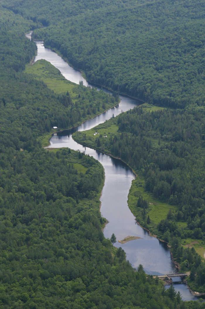
This acquisition includes over 15 miles of the Hudson River in three sections: 1) 6 miles in the Town of Newcomb south of Route 28N; 1 mile in the Town of Indian Lake at the confluence of the Indian and Hudson Rivers and 3.5 miles through the Hudson River Gorge; and 3) 5 miles south of the Tahawus mine site in the Town of Newcomb.
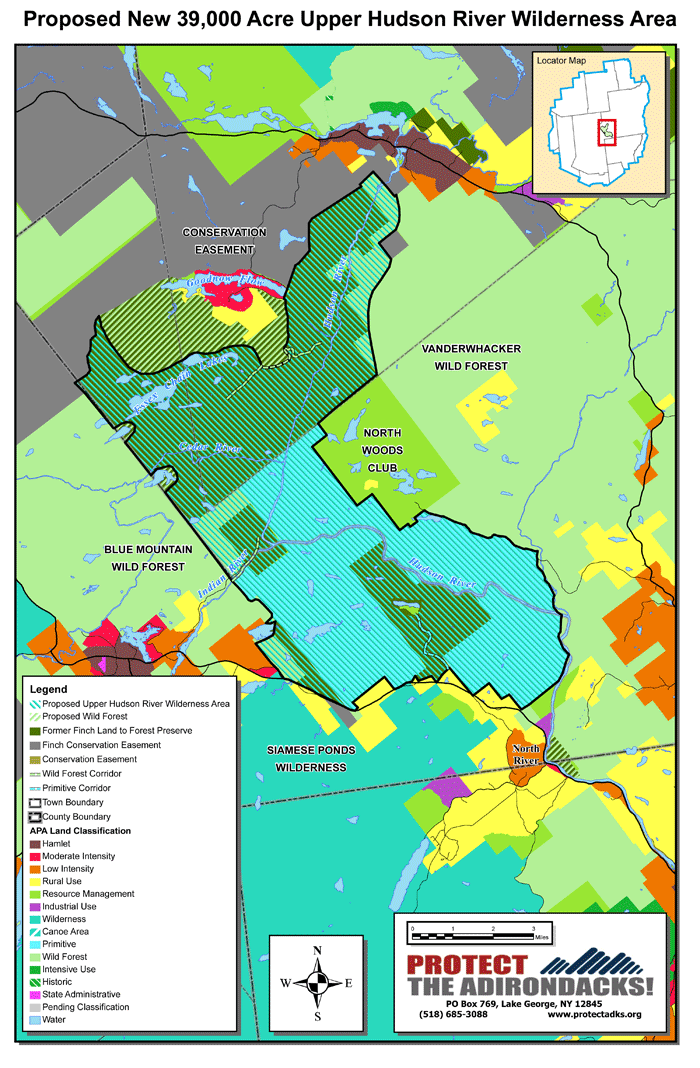
New Upper Hudson River Wilderness Area: PROTECT supports the creation of a new roughly 39,000-acre Upper Hudson River Wilderness Area that is centered on more than 22 miles of the Hudson River and the Essex Chain Lakes (see map enclosed). The new Wilderness Area will encompass new lands from the Finch purchase as well as from existing Forest Preserve lands on the western edge of the Vanderwhacker and eastern Blue Mountain Wild Forest areas as well as the Hudson Gorge Primitive Area.
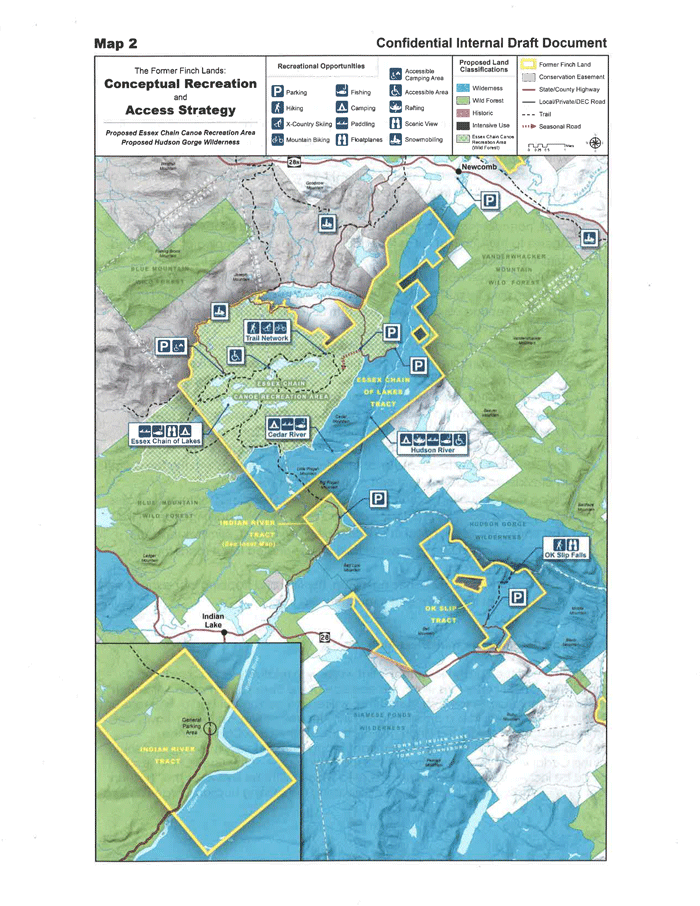
See PDF map of the proposed new Wilderness Area here and below. The DEC map of its proposal is also below. The proposed wilderness area includes:
• 7 miles of the Hudson River corridor in the Town of Newcomb should be classified as Wilderness. This should include a wide river buffer on the west shore until south of the Polaris Club Road and bridge. All land should be classified as Wilderness south of the Polaris Club road.
• All Finch lands west of the Hudson should be classified as Wilderness, with the exception of 3,000 acres just south of Goodnow Flow and north of the Essex Chain Lakes. All Wild Forest lands south of Wolf Creek in the Town of Newcomb should also be reclassified as Wilderness from Wild Forest and added to the Hudson River Wilderness.
• All Finch lands east of the Hudson should be classified as Wilderness.
• PROTECT recognizes that the Polaris Club bridge will remain until the end of 2017. PROTECT believes that the bridge should be removed as quickly as possible in 2018.
• PROTECT recognizes the desire of the DEC to create a canoe take out area in the vicinity of the Polaris Club bridge to facilitate a shorter paddling experience by the general public as well as emergency access to the river. This take out would be accessed through the existing Polaris Club Road. In addition to maintaining the Polaris Club Road to a point close to the Hudson River for public access and emergency service to the area, the DEC desires to maintain one additional road towards the western flanks of Cedar Mountain for hunting access. These objectives could be accomplished through Wild Forest corridors for the roads. These two goals could be accomplished by classifying these roads, both dead ends, as Wild Forest corridors.
• PROTECT encourages planners to promote the chief access point on the Hudson to be the Newcomb Town Beach area where paddlers can launch for a trip down river.
• The entire Finch tract that includes the confluence of the Indian and Hudson Rivers and the outer Gooley Club should be classified as Wilderness.
• PROTECT supports a Wild Forest corridor within the Finch tract at the confluence of the Indian and Hudson Rivers to meet the objectives by the paddling community for a new flat water take-out area on the Hudson before major rapids just north of the confluence with the Indian River, with accompanying road access and parking, north of the location of the present Gooley Outer Club camp buildings. This will facilitate a largely flatwater paddling opportunity from the Newcomb Beach area downriver of nearly 10 miles. This will require classification of these lands as Wild Forest. PROTECT also recognizes the desire of local governments and the commercial rafting community to continue current access to the point at the confluence of the Hudson and Indian Rivers for emergency services. PROTECT believes that a minimal amount of acreage should be utilized for Wild Forest corridors for these purposes and that all other Finch lands along the Chain Lakes Road should be classified as Wilderness, including reclassification of a section of the Blue Mountain Wild Forest.
• All Blue Mountain Wild Forest lands in the Town of Minerva north of the new take-out area and west of the Chain Lakes Road should be reclassified as Wilderness.
• The 17,000+ acre Hudson Gorge Primitive Area should be reclassified as Wilderness and combined with the new Finch lands and other Wild Forest land reclassified to Wilderness.
• The 2,900 acres of Finch lands around OK Slip Pond, and containing five miles of the Hudson River Gorge, the Blue Ledges, and OK Slip Falls should be classified as Wilderness.
• Other Finch lands that border the Primitive area and state Route 28 should be classified as Wilderness.
• The road to the camp that owns the inholding around OK Slip Pond should be classified as a Primitive corridor.
• PROTECT recognizes that all hunting camps will remain until the end of 2017, but that the public will enjoy recreational opportunities on these lands as acquisitions are completed.
• All roads within this area should be closed along Cedar Mountain, the Cedar River, Pine Lake, Mud Lake and Pisgah Mountain as well as all around the Essex Chain of Lakes except where providing public access or CP-3 access.
• PROTECT supports mountain biking on the trails and roads in the Wild Forest corridors.
• Finch lands on the east side of the Hudson across from the commercial rafting take-out in North River should be classified as Wild Forest.
3. Essex Chain Lakes
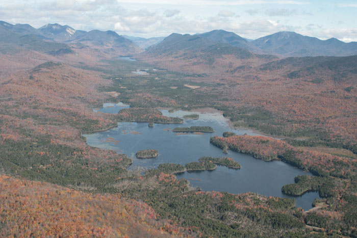
The Essex Chain Lakes area is part of an 18,000-acre tract that is largely surrounded by Forest Preserve or conservation easement lands. It’s an important tract for connectivity for wildlife and forest systems. The area has a long history of motor vehicle use, on an extensive roads network, by Finch, Pruyn and Company as well as members of various leased hunting camps. The network of eight lakes in the Essex Chain and three other ponds dominates this area.
• PROTECT calls for this area to be primarily managed as Wilderness and included within the new Upper Hudson River Wilderness area. The DEC is proposing Wild Forest with enhanced rules under a Special Management Area.
• Protect calls upon the APA and DEC to classify 10 of the 11 lakes and ponds in the Essex Chain as Wilderness. All lands south of Deer Pond and Fifth and Sixth Lakes should be classified as Wilderness.
• Wilderness Classification for the main part of the Essex Chain will prevent floatplane access and motorized access. PROTECT opposes DEC’s plan to allow seasonal floatplane access to the Essex Chain and to manage the area Wild Forest with a Special Management Area rules.
• A small Wild Forest buffer should provided around First and Pine Lakes. PROTECT recognizes the “reserved rights” to continue float plane use on First Lake and Pine Lake by The Nature Conservancy with support from the DEC. Under this agreement The Nature Conservancy would convey the float plane rights to another entity to preserve this use. PROTECT is unaware of a precedent for this type of use protection. PROTECT finds this a troubling and unwise precedent by the state and The Nature Conservancy.
• PROTECT supports the DEC’s desire to allow motorized access to an area within a canoe carry distance of Deer Pond as a paddling staging area and point of entry for the public to the Essex Chain. Access will follow the northshore road at Goodnow Flow to the Cornell Road that separates conservation easement lands (former Finch lands now owned by ATP Timber Land Invest) and future Forest Preserve lands to Deer Pond Road. The land needed to facilitate this access should not be classified as Wilderness.
• PROTECT supports the DEC’s desire to develop CP-3 campsite for disabled access, which will necessitate additional specialized motor vehicle access as far as Third Lake. The land needed to facilitate this access should not be classified as Wilderness, but could serve as the northern boundary area.
• PROTECT believes the culvert and fill between Fourth and Fifth Lakes should be removed and the natural channel restored.
The DEC has proposed a much smaller Wilderness Area and proposes that the Essex Chain be managed as Wild Forest under a Special Management Area that bans motorboats, but allows fall seasonal float plan access to 3rd Lake. PROTECT opposes this plan; see the DEC proposal below.
4. McIntyre Tracts and Hudson River south of Tahawus Mine
The Finch lands include two tracts of roughly 5,000 acres that border the High Peaks Wilderness area. The western tract includes the eastern flanks of Santanoni Mountain and the eastern tract contains the Opalescent River, Dudley Brook and extensive wetlands.
• PROTECT believes that both of the McIntyre tracts should be classified as Wilderness and added to the High Peaks Wilderness Area. On the eastern tract all areas north of the Hudson River and LeClair Brook should be classified as Wilderness. This makes a good boundary with the Wild Forest area over the rest of the Hudson River.
• PROTECT will work with the DEC and APA to best utilize the conservation easement lands and new Forest Preserve lands in the western McIntyre tract to improve public access to the Santanoni Range.
Hudson River Corridor South of the Tahawus Mine: This 5-mile section of the Hudson River should be classified as Wild Forest. This 2,000-acre area is bordered by the Tahawus Road on the west and conservation easement lands to the east, and is bisected by the former Delaware and Hudson Railroad line.
5. Boreas Ponds
The Boreas Ponds have been long identified as one of the highest priorities for public access and natural resource protection in the Adirondacks. This 22,000-acre tract is bordered by the High Peaks Wilderness Area and AuSable Club conservation easement lands to the north, Elk Lake Reserve to the east, Vanderwhacker Wild Forest and private timber lands to the west, and Boreas Highway to the south. This is expected to be the last parcel purchased by the state of the total 69,000 acres.
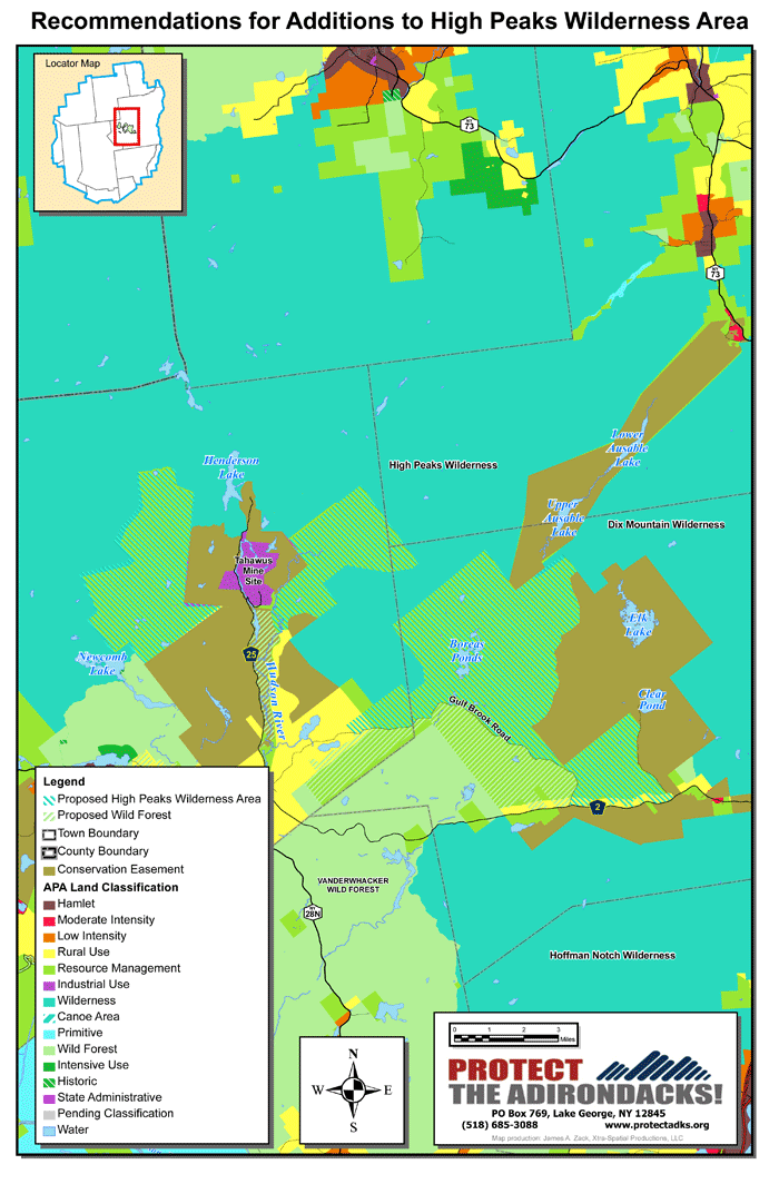
• The Boreas tract includes a major haul road that runs east-west through the property called the Gulf Brook Road. PROTECT believes that the entire area (approximately 12,000 acres) north and east of Gulf Brook Road should be classified as Wilderness and added to the High Peaks Wilderness Area. This includes the Boreas Ponds and over 3 miles of The Branch.
• The more than 35 miles of roads north and east of Gulf Brook Road should be closed.
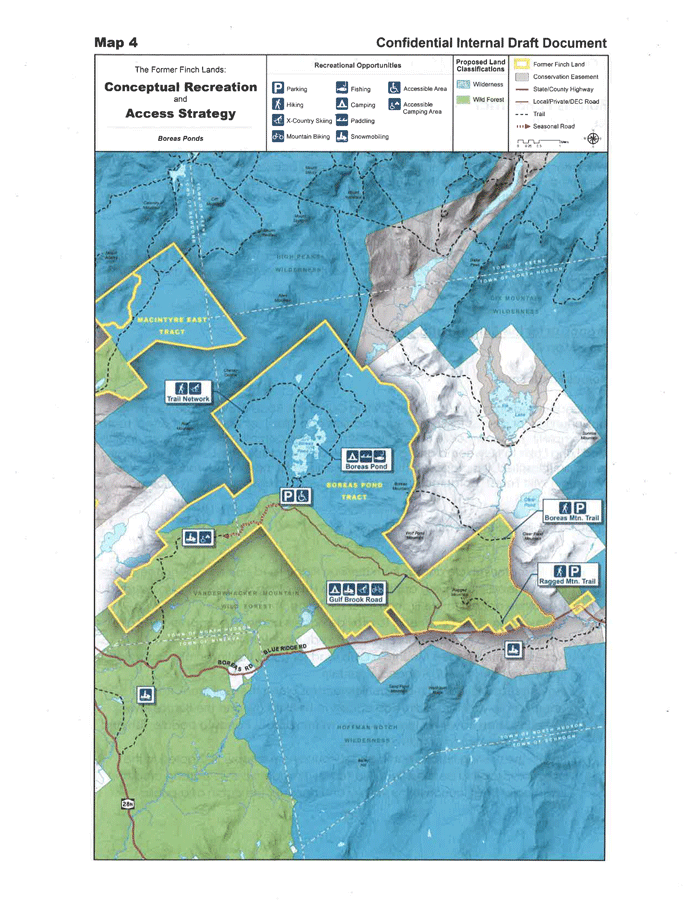
• PROTECT supports DEC planning that Gulf Brook Road will provide access to the Boreas Ponds from an area near the Boreas River Flow at the dam. This will provide access to the three Boreas Ponds. This road will form the boundary between Wilderness and Wild Forest areas. PROTECT opposes DEC’s proposal for a smaller Wilderness Area along the Gulf Brook Road and around the Elk Lake-Clear Pond Preserve.
• PROTECT believes that the “Boreas Lodge” on the Boreas Ponds should be removed. It is our understanding that the lodge is scheduled to be removed in 2016.
A map of the PROTECT proposal is below. The DEC proposal, which includes less Wilderness lands follows.

Boreas Lodge and historic cabin in North Hudson. PROTECT calls for demolition of the Boreas Lodge and restoration of the site and maintenance of the historic cabin for administrative purposes.
• PROTECT recognizes the desire by the DEC and Town of North Hudson to maintain a historic cabin near LeClaire Brook and the Gulf Brook Road as some form of administrative building. It is believed that this cabin is the oldest structure in the Town of North Hudson.
• The area south of Gulf Brook Road (approximately 10,000 acres), and the road itself, should be classified as Wild Forest and added to the Vanderwhacker Wild Forest Area.
• PROTECT recognizes the desire by local communities to utilize the more than 10-mile long Gulf Brook Road as a snowmobile connection route that links the Town of North Hudson with Minerva to the south and Newcomb and Indian Lake to the west.
• PROTECT recognizes that the dam on the Boreas River will be maintained by the DEC.
6. Benson Tract
The Finch lands include a 3,891-acre-acre tract that connects several isolated tracts in the Shaker Mountain Wild Forest area.
• PROTECT supports a Wild Forest classification for the 4,000-acre Benson tract.
7. Outlying Smaller Tracts
The Finch lands include over 5,000 acres in eight tracts spread throughout the southern Adirondacks. These lands include the Ice Meadows on the Hudson River in the Town of Chester and the Thousand Acre Swamp in the Town of Edinburgh. The Nature Conservancy also plans to transfer to the state the Saddles Tract, which borders the Blue Line in the Town of Whitehall. PROTECT supports these additions to the Forest Preserve.
8. Classification of Waterbodies
Consistent with the recent court decision in the Low’s Lake case, as required by the APA Act and the Adirondack Park State Land Master Plan, all lakes, rivers and ponds, or portions thereof, on the Finch lands should be classified, consistent with the surrounding uplands. This is a critical issue for the Essex Chain Lakes and Boreas Ponds.
9. Roads Maintenance
PROTECT does not agree with the idea that the DEC should maintain and operate “borrow pits” or “gravel pits” along Forest Preserve roads for maintenance purposes.

