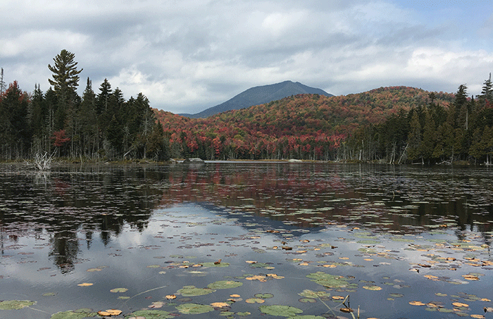
The Boreas Ponds are open to the public and a canoe trip or hike there is spectacular.
Just after Labor Day weekend this year, the Department of Environmental Conservation (DEC) completed its work to fully open up public access to the Boreas Ponds, in the southern High Peaks Wilderness area. These beautiful ponds are now easily accessible for people to either canoe or to hike. New state facilities were constructed over the past two years to rehabilitate the 6-mile-long Gulf Brook Road, build parking lots, public education kiosks, and canoe carries and canoe launches to make this extraordinary natural wonder fully accessible to the public. The reconstructed road and new access points opens up a new southern gateway to the High Peaks Wilderness Area and makes easily reachable one of the most scenic and visually dramatic areas in the Adirondacks. Paddling through the network of three inter-connected Boreas Ponds gives one the sensation of paddling through mountaintops.
The Boreas Ponds were purchased by the State of New York from the Adirondack Chapter of the Nature Conservancy. This was part of the 165,000 acre protection deal of the former Finch, Pruyn and Company lands. In 2010, Governor David Paterson purchased a conservation easement on 95,000 acres of the former Finch lands. From 2012-2015, Governor Cuomo purchased over 65,000 acres as Forest Preserve, including the Essex Chain Lakes, Blue Ledges in Hudson Gorge, long stretches of the Hudson, Opalescent and Cedar Rivers, and the Boreas Ponds, among other natural gems. Over 11,000 acres surrounding the Boreas Ponds was classified as Wilderness in early 2018 by the Adirondack Park Agency (APA), and 9,000 acres south of the ponds, including the Gulf Brook Road, was classified as Wild Forest. The lands around the Boreas Ponds connected the High Peaks Wilderness and Dix Mountain Wilderness areas, which were combined into one grand 275,000-acre High Peaks Wilderness Area in 2018. The enlarged High Peaks Wilderness Area is now the third largest Wilderness area east of the Mississippi River, behind the 1-million-acre Everglades in Florida and the 350,000-acre Okefenokee Swamp in Georgia. This is yet another thing that highlights the national and international importance of the Adirondack Park.
The Boreas Ponds classification was part of a larger classification package of over 50,000 acres approved by the APA in early 2018, where over 25,000 acres was classified as Wilderness and more than 26,000 acres was classified as Wild Forest. The High Peaks Wilderness was expanded by over 25,000 acres with Wilderness classifications of over 12,500 acres around Boreas Ponds and Casey Brook tracts and over 13,000 acres around the MacIntyre east (headwaters of the Opalescent River) and MacIntyre West (flanks of Santanoni) tracts. The Gulf Brook Road generally delineates the Wild Forest and Wilderness boundary line between the High Peaks Wilderness to the north and the Vanderwhacker Mountain Wild Forest to the south. The lands to the north of the Gulf Brook Road are Wilderness, where motorized recreation and bicycles are prohibited, while the lands to the south are classified as Wild Forest, where motorized recreation and bicycle use are allowed in designated areas. The “4 Corners” is a junction where four logging roads intersected. The 4 Corners parking lot marks the end of the road for public motor vehicle use as the three former logging roads at that point are gated closed.
Since 1970, the Adirondack Forest Preserve has seen an expansion of its general motorless lands classified of Wilderness, Primitive and Canoe from 1,072,000 acres to 1,241,000 acres, roughly a growth of 169,000 acres in nearly 50 years. Over 25,000 acres alone of new Wilderness was added as part of the Boreas classification in 2018. Clearly, gaining new Wilderness lands in the Adirondacks is always challenging, always difficult, and always hard. Wild Forest areas have grown by around 159,000 acres since 1970.
Public access to the Boreas Ponds is primarily set up along the controversial 6-mile-long Gulf Brook Road. During the Finch, Pruyn days this was the main haul road where log trucks were loaded at numerous landings with trees cut on over 25,000 acres of managed forestlands. Prior to state ownership, this road was in rough shape, suitable for high-riding pickup trucks and log trucks, but a challenge for passenger vehicles. The DEC worked on this road all through the summer of 2018 and through the spring and summer of 2019. Lots of boulders were dug out of the road and tons of gravel were brought in. The drainage was improved. These activities appeared to involve very little tree cutting and DEC appeared to stay within the narrow gravel road corridor. The DEC appears to have learned a lot from previous disasters in Forest Preserve road management, such as the Bear Pond Road in the Watson’s East Triangle Wild Forest area.
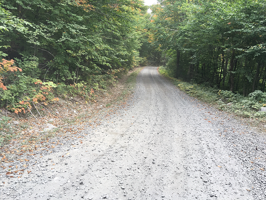
A scene from the Gulf Brook Road, freshly graded and retrenched for drainage, with tons of new gravel.
There are now three parking lots on the Gulf Brook Road; one just off of the Blue Ridge Highway, another that is still under construction 3.5 miles in (where cars can be parked, but where work is still ongoing), and the third at the “4 Corners” at the end of the road six miles in and roughly 0.8 miles from the ponds. The 4 Corners parking lot has 17 parking spaces; 13 parking spaces for the general public, two parking spaces for disabled individuals, and two “trailered parking only” spaces presumably for vehicles with horse trailers. The facility is newly built. The parking spaces are numbered and there are a half dozen no parking signs around the parking lot. The signs and kiosks are all new, not yet weathered, pummeled by falling trees, pierced with bullet holes, or chewed by porcupines.
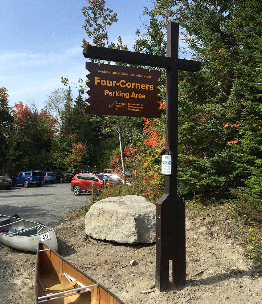
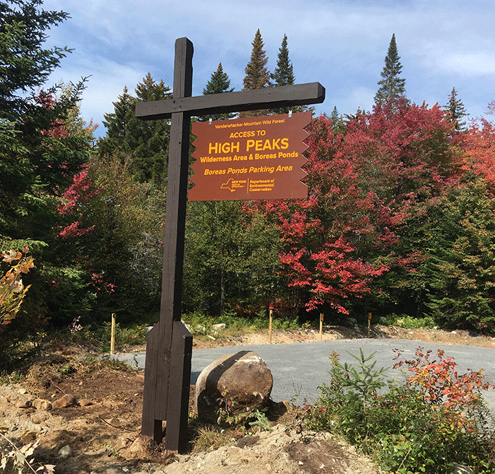
The sign post at the 4 Corners parking lot, the main parking area to access the Boreas Ponds.
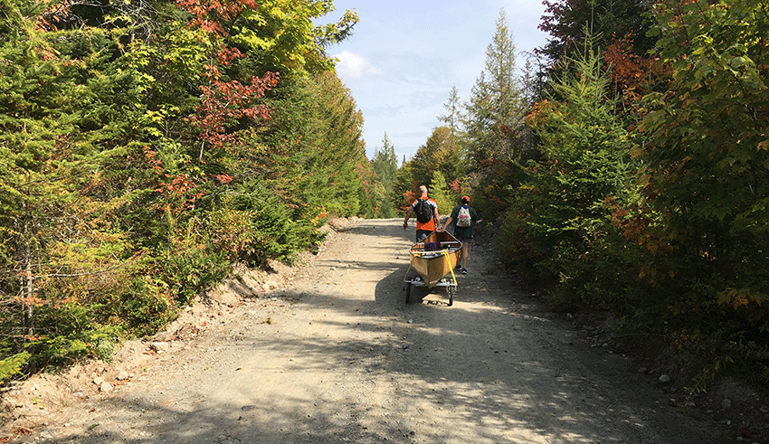
The 4 Corners parking lot has ample public information about hiking trails and other recreation opportunities available at the tract. There is a bathroom building designed to accommodate disabled individuals. It’s an easy walk from the parking area to the LeBiere Flow, where a new canoe launch was installed, or to walk or carry a canoe on the roughly 0.8 miles on a dirt road down the Boreas Ponds.
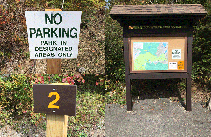
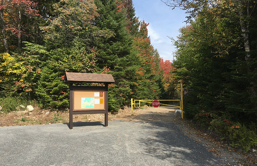
These pictures show the new 4 Corners parking area, which limits parking to 15 sites and two for trailered vehicles. All parking spots are numbered. While there are lots of “No Parking” signs there are also lots of areas where overflow parking has occurred. The picture above shows the kiosk and gated road that leads to the ponds. The carry to the Boreas Ponds is along a dirt road that leads to the canoe launch next to the dam at the outlet of the ponds.
The carry down to the Boreas Ponds is an easy-going dirt road with some small rises. The public is allowed to ride bikes on the Gulf Brook Road and on the road/carry down the ponds. A third of a mile or so in on the road to the ponds, the carry from the LeBiere Flow connects to the road for paddlers who opted to shorten their carry with a paddle on the flow. The takeout from the LeBiere Flow to the road is on the lefthand side as you paddle upstream. It is not advisable to keep paddling up the LeBiere Flow all the way to the ponds as there are rocks and elevation gain in the stream leading to the dam.
At around 0.6 miles in there’s a newly built parking lot with six parking spaces, four for the general public and two for disabled individuals. The road leading to this parking area was classified by the APA-DEC as a Wild Forest corridor, though it’s really an illegal peninsula jutting into Wilderness lands. The DEC will regulate these parking spaces via a permit program that is expected to be launched in 2020. The fact that perfectly healthy people, anybody who puts in for a permit, could get a permit to drive within 0.2 miles of the ponds is indefensible and is just plain bad public policy. Many expected that the Boreas classification would involve access for the disabled community under the successful and longstanding CP-3 policy that provides disabled people with special access with motor vehicles to the Forest Preserve, though not in Wilderness, Primitive or Canoe. The purpose of special access for disabled individuals is that it’s special. The fact that anybody will be able to get one of these general use permits to drive to the inner parking area 0.2 miles from the Boreas Ponds undermines the very essence of the DEC’s CP-3 policy for disabled access and is a major failure in the DEC’s overall public recreation planning for the Boreas Ponds. The inner parking area should be available only for people who have CP-3 access.
The new sign at the inner permit-only parking area and trailhead to the ponds. Two sites are reserved for disabled individuals and four sites will be available for the general public through some form of reservation system.
The canoe launch to the Boreas Ponds is accompanied by the soundtrack of water flowing over the sturdy concrete dam some 50 feet away. There’s a bridge over the dam that provides access to the foot trails on the other side. A sign is posted on the dam that prohibits bicycle use beyond the dam.
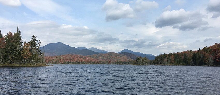
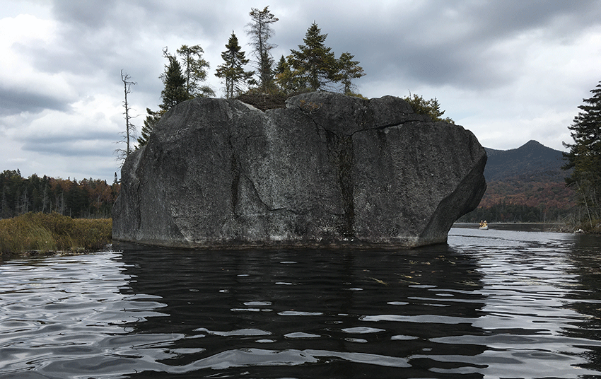
The three Boreas Ponds are broken up with islands. A jagged shoreline wraps around a dozen or so bays and connects with extensive wetlands. The abundant native plants accentuate the beauty of the area. Erratics dot the shore, and one dramatic giant boulder stands in open water. What makes the Boreas Ponds experience different from paddling on other lakes and ponds in the Adirondacks is the stunning scenic beauty that envelopes the ponds. Whether one is paddling out, or paddling back, paddling east or west, the views are extraordinary. The views change like a photo belt. A dozen High Peaks can be seen at different points. From the canoe launch, Allen, Marcy, Haystack, Gothics, Basin, and Saddleback mountains stand to the north. Once out on the ponds, the views change with every dozen canoe paddle strokes. There’s a window to Shepherd’s Tooth on the Algonquin Range at one location, views of Dix Mountain at another, an unreal view of the Sawteeth Mountains, and views of Blake and Colvin, among others, at other points. Gothics Mountain is massive at some points and then seems to disappear. Allen Mountain looms most prominently over the ponds, not seeming quite as daunting as when viewed from other locations. The jagged Boreas and Moose Mountain chains stand in the east and west.
The farthest point that one can paddle away from the dam leads to a culvert that drains a wetland complex into the north end of the 3rd pond. There is a large diameter culvert there that channels the inlet into the ponds and also facilitates a road crossing on the former logging road to White Lily Pond, which is now designated as a foot trail. There are knee-high cedar trees growing up through the rubble of the gravel road. Surrounding this wetland are towering cedars, tamaracks, hemlocks, white pines and maples running up the hillsides. A major storm in future years will likely blow out this culvert and future storms will eat away the fill. There are any number of twisted culverts deep in the Forest Preserve rusting away in the sunshine on a wetland meadow, long since dislodged and washed out from an old road bed. There are over a hundred miles of roads like the road to White Lily Pond that cross-cross the former Finch, Pruyn lands on both side of the Gulf Brook Road, through Forest Preserve areas now classified as Wilderness and Wild Forest. The amount of road retained by the state as public motor vehicle roads was around 7 miles. The rest will be slowly eaten away by time, beavers, and the forest.
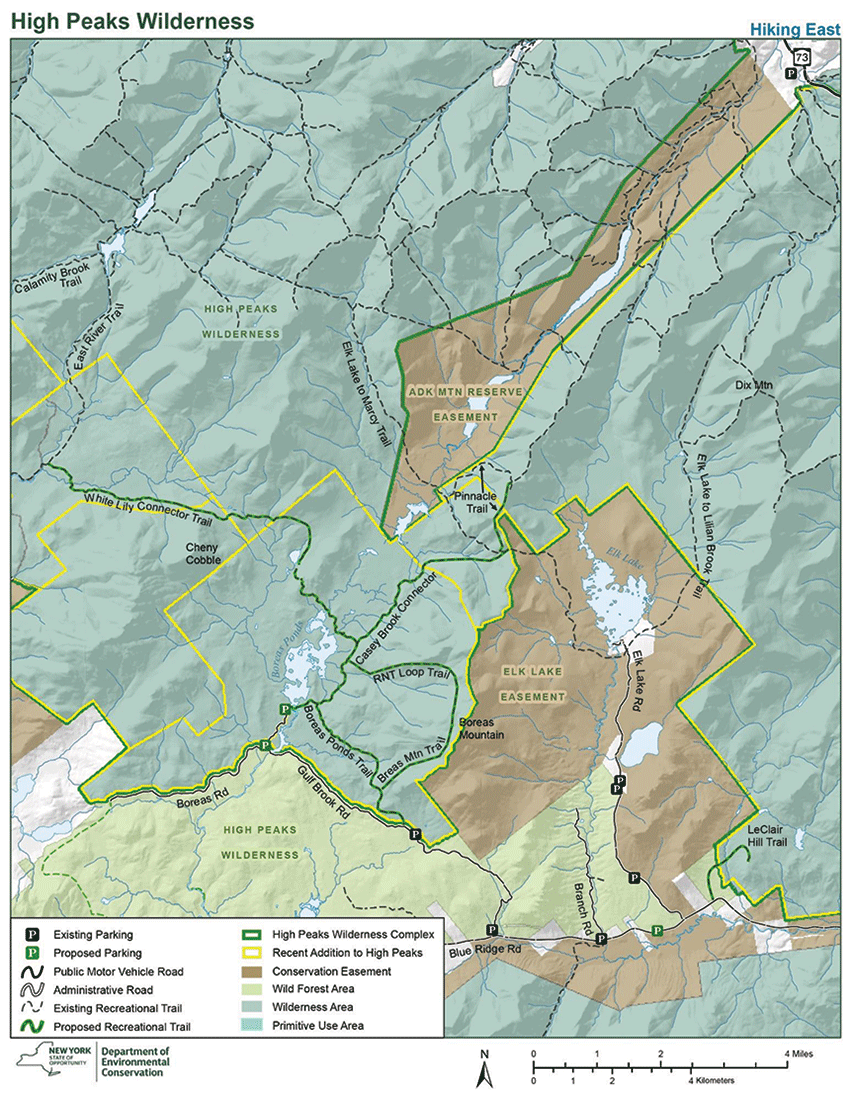
A map of the Boreas Ponds classification.
Any time land is added to the Forest Preserve the Adirondacks grows wilder. Protections under Article XIV of the State Constitution require that lands are forever kept as wild forest lands. There’s plenty of great country and wild places that never see a footprint in both Wilderness and Wild Forest areas. In the history of the Adirondack Park, the acquisition of the Boreas Ponds and its classification as Wilderness and inclusion in the High Peaks Wilderness Area will be written as a landmark event, and an important link in the chain between generations that have worked to defend and protect the last great wilderness in the eastern U.S.
There are many folks who wanted to be able to drive motor vehicles across the Boreas Pond dam to White Lily Pond and beyond. Some demanded that dozens of miles of roads should be retained to allow the public to drive completely around the Boreas Ponds, in a loop akin to a national park setup. There were many who wanted every inch of roads closed. The future of a potential class II community connector snowmobile trail that could connect to the Gulf Brook Road will be determined as part of a lawsuit brought by Protect the Adirondacks that is currently in front of the NYS Court of Appeals, the state’s highest court. That we’re left to squabble about 7 miles of road out of more than 100 miles shows the beauty and promise of the public constitutionally protected Forest Preserve in New York, the people’s land in every way. These are lands protected through a 125-year bipartisan and multi-generational commitment of New Yorkers, a continuous work in progress, a landscape shaped by scores of major public decisions.
Wilderness in the Adirondack Park is forward-looking. When lands are classified as Wilderness, management looks ahead at what these lands can become, and not backwards at what these lands were. Wilderness lands, and the Forest Preserve in general, in the Adirondacks are strewn with the relics and ruins of past uses and settlements. There has been an argument that there should be more active retrofitting actions when the state purchases new lands for the Forest Preserve where trees are planted along road corridors, geometric road shapes like bench cuts, rock cuts, and borrow pits are remediated, culverts and fill are removed, and natural stream and wetland channels are restored. During the Boreas Ponds classification a debate about the idea of removing the dam at the outlet of the ponds was taken off the table in the deliberations of state agencies, never researched, analyzed or considered. There’s time in the future to revisit this question, or perhaps the Boreas Ponds dam in the decades ahead may go the way other dams in the High Peaks Wilderness, like Marcy Dam and the dam at the Flowed Lands, which were not maintained, breached, and crumbled.
And, that’s what Wilderness is all about, a place where we intentionally draw boundary lines and say that everything inside will be managed differently from lands outside. The lands classified as Wilderness are lands where wild nature dominates, unfettered by humans to the greatest extent possible, where cedar trees can grow up through gravel roads and dams are breached. A place where the forest is allowed to reclaim vast areas, eat away the roads, overgrow the log landings, bury the culverts, and slowly transform, remake and recreate a wild landscape where natural processes are unimpeded and untrammeled by humans.


