Submit your letter for a motorless Boreas Ponds, expanded Wilderness areas, and a wild Adirondack Park today!
In November and December, the State of New York will be holding classification hearings on over 45,000 acres of newly purchased and reclassification of 5,000 – 10,000 acres of existing Forest Preserve lands. Over 50,000 acres of Forest Preserve lands are on the line. Classification is the first step in determining how these lands will be managed in the future and what types of recreational uses will be allowed. The Adirondack Park Agency (APA) has released options for the classification of these lands and has organized eight public hearings across New York.
Protect the Adirondacks is advocating for a comprehensive classification package of 36,000 acres of Wilderness and 14,000 acres of Wild Forest. Public comments must be submitted by mail, fax or email by December 30th and there will be eight public hearings at various locations throughout New York in November and December. Public comments will be accepted by mail, fax and email. See information below on where to send a letter or your can send in an automatic email letter using the form below.
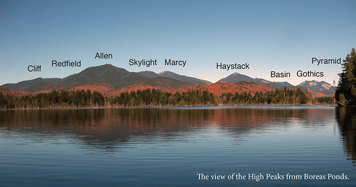
This is a historic opportunity to win new protections for the extraordinary Boreas Ponds and protect other important areas of the Forest Preserve. Through this classification we can expand the High Peaks Wilderness area, make the Boreas Ponds a motorless Wilderness area, and create a new 12,000-acre West Stony Creek Wilderness area in the southern Adirondacks. This is an opportunity that we must seize.
Below, please find talking points for letters and public comments.
These proposals are based on how newly acquired lands conform to the guidelines of the Adirondack Park State Land Master Plan. The APA has released just 4 options for classification of the Boreas Ponds and single options for all other Forest Preserve lands subject to classification.
Help Make the Boreas Ponds a Motorless Wilderness Area
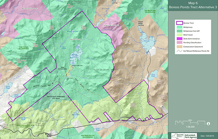
1. Classification of Boreas Ponds. The entire shoreline of Boreas Ponds should be classified as Wilderness. The Wilderness boundary should extend at least one mile from the Boreas Ponds to the Gulf Brook Road, which should form the Wild Forest-Wilderness Boundary. (The map below shows our recommendation for Boreas Ponds.) Over 13,500 acres should be classified as Wilderness and all roads north of the Gulf Brook Road should be closed. Over 8,500 acres of newly purchased lands south of Gulf Brook Road should be classified as Wild Forest. This recommendation allows for the public to utilize the Gulf Brook Road to a point 1 – 1.5 miles from the Boreas Ponds to LaBiere Flow, which could serve as a staging area for accessing the Boreas Ponds through trails, canoe routes, and portages.
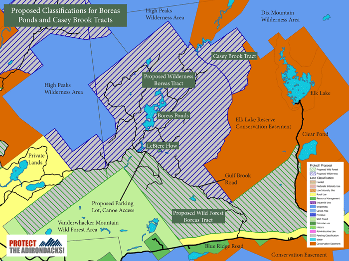
The map above details the proposal by Protect the Adirondacks to classify new state Forest Preserve purchases around the Boreas Ponds as a mixture of Wilderness and Wild Forest. PROTECT calls for over 13,500 acres of these lands to be classified as Wilderness and over 8,000 acres as Wild Forest. We advocate that the Gulf Brook Road should be part of the Wild Forest area and open for six miles so that the public can access the Boreas Ponds with a canoe staging area.
This classification also minimizes negative impacts to the Forest Preserve by keeping snowmobile trails on existing roads. Under this classification, a Minerva to North Hudson snowmobile trail could be routed on the Gulf Brook Road and other tote roads in Wild Forest lands. Governor Cuomo has committed to build this trail. Over 1,000 trees per miles are destroyed on snowmobile trails newly cut through the Forest Preserve. Whether it is wise or not, whether there is adequate snowfall or not, the Cuomo Administration is determined to build a snowmobile trail through this area to connect Newcomb/Minerva and North Hudson. PROTECT believes that this route should cause the least impact to the Forest Preserve.
Option 2 Should be Revised to Protect the Boreas Ponds and Expand the High Peaks Wilderness Area
2. Option 2 for Boreas Ponds Should be Revised. Option 2 (see all options below), one of four proposals released by the APA, should be revised to classify the entire shoreline of the Boreas Ponds as Wilderness. The Wilderness boundary should extend south to the Gulf Brook Road. Wilderness lands provide non-motorized public recreation.
Below are four maps that show the four options released by the APA for public hearing.
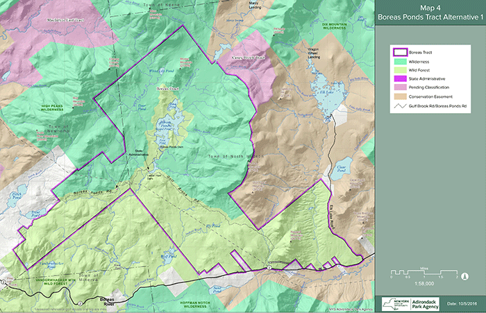
Option 1 is supported mainly by advocates of extensive motorized access. It classifies the entire lakeshore of Boreas Ponds as Wild Forest, which would allow motor vehicles to drive all around the ponds and use of motor boats. Option 1 should be rejected.
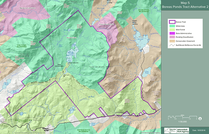
Option 2 should be modified to make the entire shoreline of the Boreas Pond Wilderness. The Gulf Brook Road should form the Wilderness-Wild Forest boundary. All lands north of the Gulf Brook Road should be Wilderness, all lands south should be Wild Forest.
Option 3 extends the Wilderness area south, but includes an island of Wild Forest lands at the south end of the Boreas Ponds. The other major problem is the nearly 9-mile long Wild Forest corridor that runs through the Wilderness lands. Classifications should be for big blocks of Wilderness and Wild Forest. Spot zoning and use of motorized Wild Forest corridors should be rejected.
Option 4 extends the Wilderness area south, but includes an island of Wild Forest lands at the south end of the Boreas Ponds. The other major problem is the nearly 9-mile long Wild Forest corridor that runs through the Wilderness lands. Classifications should be for big blocks of Wilderness and Wild Forest. Spot zoning and use of motorized Wild Forest corridors should be rejected.
3. Lands South of Gulf Brook Road should be Wild Forest. PROTECT calls for classification of roughly 8,000 acres south of the Gulf Brook Road to be classified as Wild Forest (see map above). These lands could potentially provide different forms of motorized public recreation. PROTECT believes that motorized uses should be kept in Wild Forest areas and should not be allowed in areas classified as Primitive or Wilderness.
4. Future of Boreas Ponds Dam should be Analyzed. The APA should perform an analysis of retention of the Boreas Ponds dam to assess long-term management, ecological, and recreational issues. There should be public disclosure of the ramifications of retention and removal of this dam.
5. No Spot Zoning. Two classification options (3 and 4 shown above) for the Boreas Ponds utilize “spot zoning” techniques to create islands of one classification of lands within another; option 3 creates a Wild Forest island; option 4 creates a Primitive island. Sound Forest Preserve management is built upon consistent classification of large blocks of Forest Preserve lands, not checkerboards of conflicting uses. Spot zoning shoehorns-in conflicting uses.
6. No Wild Forest Corridors. Two classification options (3 and 4 shown above) for the Boreas Ponds create Wild Forest corridors. These corridors violates Forest Preserve laws and regulations. These motorized corridors create classifications that are, in essence, Wilderness areas with roads, which would set a terrible precedent.
7. Historic Cabin at 4 Corners should be a .25 acre State Administrative Area or Historic Area. The historic cabin at the 4 Corners should be maintained for management purposes. A quarter acre area around the cabin should be classified as State Administrative or Historic. The state needs to release its plan for the future use of this cabin.
New 12,000-acre West Stony Creek Wilderness Area should be Analyzed and Approved
8. APA Should Create New West Stony Creek Wilderness Area. In the southern Adirondacks, west of Northville, there is almost 3,900 acres of newly purchased Forest Preserve lands. This tract contains three Forest Preserve inholdings and borders 9,000 acres of of roadless Forest Preserve lands. PROTECT is advocating that these lands be formed into a new 12,000-acre West Stony Creek Wilderness Area. The 9,000 acre tract contains old growth forests, steep slopes, 1,500 foot high mountains, and wetlands. The two tracts combined contain over 7 miles of the West Stony Creek river corridor, which is classified as “Scenic” under the Wild, Scenic and Recreational Rivers Act. The newly purchased lands contain a vast wetland complex.
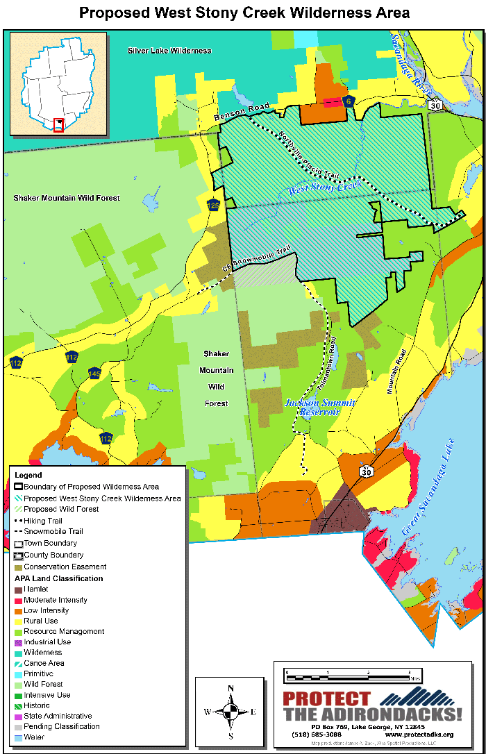
This map shows the proposed of West Stony Creek Wilderness Area in the mountains west of Northville.
Unfortunately, the APA has proposed that the 3,900 acres of new lands should be classified as Wild Forest and refused to consider a new Wilderness area. The APA’s evaluation of the viability of potential new Wilderness areas include analysis of sensitive soils, steep slopes, high elevations, extensive wetlands or other unique natural communities, among other factors. Any fair and rational analysis of this 12,000-acre complex should conclude that the extenisve old growth, abundant wetlands, seven miles of West Stony Creek, steep slopes and 14 peaks between 1,500-2,000 feet in elevation merit a Wilderness classification. These lands contain no motorized trails.
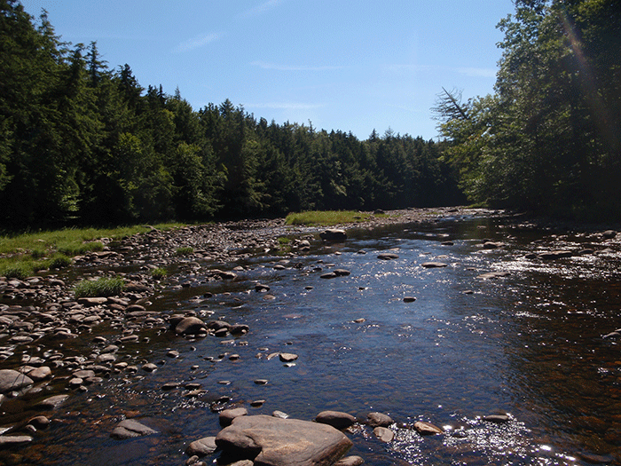
West Stony Creek. Big and wide, this shallow river swells to high levels with rainstorms and snowmelt because of its large watershed. This river is classified as “Scenic” under the NYS Wild, Scenic and Recreational Rivers Act.
MacIntyre Tracts should be Classified as Wilderness, Hudson River Tract as Wild Forest
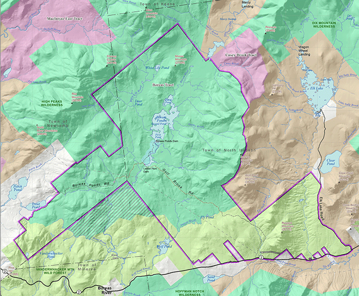
9. MacIntyre West Tract should be Classified as Wilderness. The 7,365-acre MacIntyre West tract should be classified as Wilderness. This tract includes the flanks of Santanoni Mountain and Bradley Pond. This tract should be added to the High Peaks Wilderness. (See map below.)
10. MacIntyre East Tract and Hudson River. On the MacIntyre East Tract (see map above) 4,446 acres should be classified as Wilderness in the northern section of this tract, which contains four miles of the Opalescent River. The southern portion of this tract includes 1,600 acres that should be classified as Wild Forest, including five miles of the Hudson River. The Wild Forest area is interspliced with a county road and railroad line.
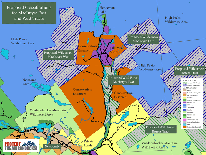
The map above shows the MacIntyre East and West tracts in the highlands on the south side of the High Peaks Wilderness area.
11. Other Important Lands. This public hearing includes proposals for other tracts, including Wild Forest classifications for the Thousand Acre Swamp, Cat Mountain and the Berry Pond tracts in the southern Adirondacks. The APA also recommends Wilderness classication for the 1,400-acre Casey Brook tract that links the High Peaks and Dix Mountain Wilderness areas. PROTECT supports these classifications.
Click here to review materials from the Adirondack Park Agency. See “State Land Classification” on the front page for a variety of materials.
Eight Public Hearings are Scheduled across the New York
November 9, 2016
7:00 PM
Adirondack Park Agency
1133 NYS Route 86
Ray Brook, NY
November 14, 2016
6:00 PM
Northville Central School
131 South Third Street
Northville, NY
November 16, 2016
7:00 PM
Newcomb Central School
5535 NYS Route 28N
Newcomb, NY
November 21, 2016
7:00
Schroon Lake Central School
1125 Route 9
Schroon Lake, NY
November 28, 2016
7:00 pm
Rochester Institute of Technology
Louise Slaughter Hall
Parking in lot “T”
Rochester
November 29, 2016
6:00 pm
Canton High School
99 State Street
Canton
December 6, 2016
7:00 PM
Bear Mountain Inn
3020 Seven Lakes Drive
Tompkins Cove, NY
December 7, 2016
2:00 PM
NYS Department of Environmental Conservation
1st Floor Meeting Room
625 Broadway
Albany, NY
Public Comment Letters must be Submitted to the Adirondack Park Agency by December 30, 2016. Please Submit your Letter Today!
Letters can be mailed, faxed or emailed to:
Kathleen D. Regan, NYSAPA
PO Box 99, 1133 State Route 86,
Ray Brook, NY 12977
Email: ClassificationComments@apa.ny.gov
Fax: 518-891-3938
Thank you very much for standing up for Wilderness and a wild Adirondack Park!


