Just inside the Blue Line in the southern Adirondacks in the Towns of Bleecker and Johnstown, a new 1,118-acre, 26-lot subdivision on lands zoned Resource Management is poised for approval by the Adirondack Park Agency (APA). The subdivision calls for 24 residential housing units. The application has been completed, and now the APA must either issue a permit or send the project to an official adjudicatory public hearing. The developer is a professional outfit called New York Land & Lakes, and it completes a half dozen major subdivisions each year throughout the northeast. This is its first project in the Adirondack Park.
This development involves lands of the former Woodworth Lake Boy Scout Camp on an 1,118-acre site that was operated by the Boy Scouts from 1950-1992 as a retreat center and sold in 2013. On the tract, there are two lakes, Hines Pond and Woodworth Lake, and extensive wetlands and steep slopes. The tract is bordered by Forest Preserve in the Shaker Mountain Wild Forest around the north end. Some 97% of this tract is classified as Resource Management and 3% Low Intensity under the APA Land Use and Development Plan.
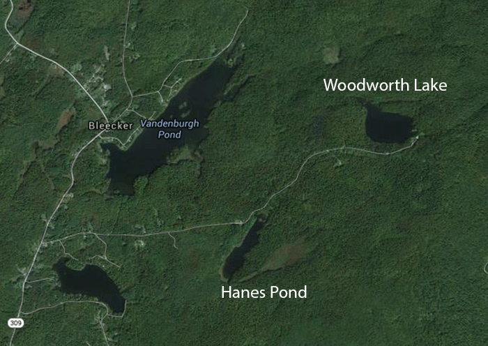
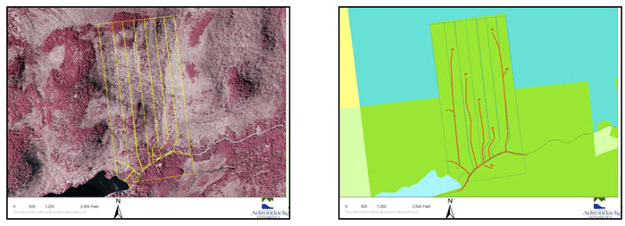
Aerial picture of the proposed 1,100-acre subdivision around Hines Pond and Woodworth Lake in the Town of Bleecker.
This is the biggest Resource Management project since the Adirondack Club & Resort (ACR) project was approved in 2012. The ACR project cut 4,739 acres of Resource Management lands into 80 lots. The maximum development density for Resource Management is 15 units per square mile, which averages to 42.7 acres per principal building.
The APA Act states:
The basic purposes and objectives of resource management areas are to protect the delicate physical and biological resources, encourage proper and economic management of forest, agricultural and recreational resources and preserve the open spaces that are essential and basic to the unique character of the park. Another objective of these areas is to prevent strip development along major travel corridors in order to enhance the aesthetic and economic benefits derived from a park atmosphere along these corridors.
Finally, resource management areas will allow for residential development on substantial acreages or in small clusters on carefully selected and well designed sites.
Resource Management lands are thus supposed to be the most highly regulated private lands in the Adirondack Park.
In many ways, Resource Management lands represent the area of the Adirondack Park where the APA Act has had the greatest impact. These lands have seen a lower level of development since the APA Act than beforehand, though state purchase of conservation easements, overwhelmingly on Resource Management lands, has clearly helped limit development in these areas.
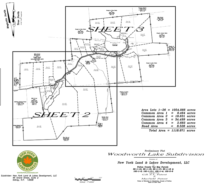
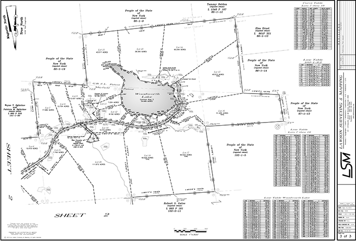
An overview of the proposed Woodworth Lake subdivision.
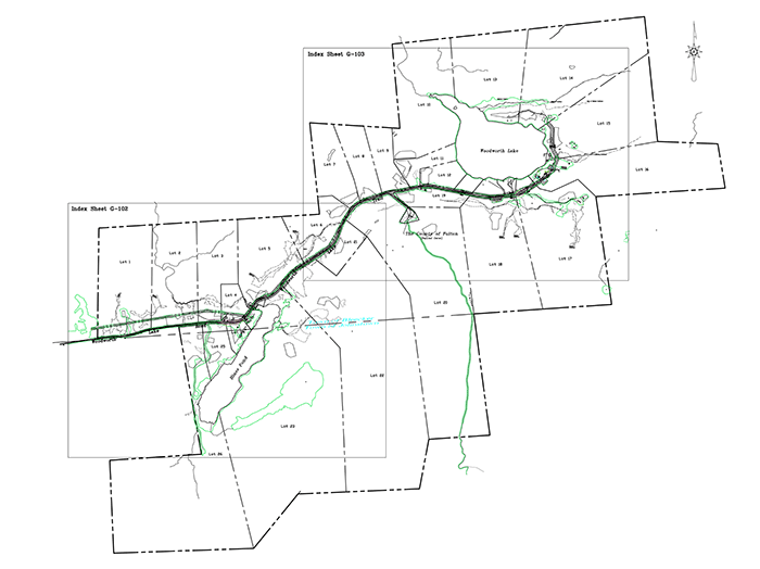
More detail of the lot design for the proposed 1,100 acre subdivision around Woodworth Lake.
Close-up of the lots proposed to be subdivided around Hines Pond.
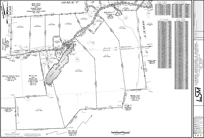
Close-up of the lots proposed to be subdivided around Woodworth Lake.
New York Land & Waters is a seasoned developer with a long track record. It made its decision to enter the Adirondack Park land subdivision and development market after the APA’s decision on the Adirondack Club & Resort project. In many ways, New York Land & Waters followed its standard recipe around Woodworth Lake that it used in other subdivision projects around New York. They have subdivided large tracts running from several hundred to several thousand acres. In these projects, small lots were cut in areas where they could be maximized and other lots were cut bigger to contain wetlands, steep slopes, and other restrictive land features. Each house location was isolated and secluded.
The proposed Woodworth Lake subdivision followed this standard method, with lots ranging from 6 to 130 acres. The larger lots have steep slopes and wetlands. The 26-lot development is the maximum amount they can get in Resource Management. The design plan utilized a standard piano-key lot design with buildings focused on the two lakes on the property — Hines Pond and Woodworth Lake.
New York Land & Lakes cites other subdivisions around New York for its bonafides. In the Town of Tusten, Sullivan County, they subdivided 2,500 acres into 100 lots, ranging from 3 – 70 acres (an average of 25 acres). In the Town of Smithville, Chenango County, they subdivided 1,400 acres into 72 lots, ranging from 5 – 90 acres (an average of 19.44 acres). In the Town of Meredith, Delaware County, they subdivided 1,100 acres into 35 lots, ranging from 5 – 147 acres (an average of 31.4 acres). In the Towns of Highland, Herkimer, and Newport in Herkimer County, they subdivided 4,800 acres into 326 lots, ranging in size from 5 – 200 acres (an average of 14.7 acres). The big concession to the APA Act and the Adirondack Park is that, in general, lots were cut larger than their standard practice.
A town road accesses the tract and connects to a paved interior private road that connects the two lakes. All of the existing structures from the Boy Scout compound will be retained and included in the various lot offerings. A 1-acre inholding parcel is owned by Fulton County and holds communications towers. Utility lines exist in the property and the subdivision will extend and alter the road in a few locations.
New York Land & Lakes maintains that it has designed this project around criteria supplied by the APA for “Ecological Influence Zone” analysis that seeks to contain development impacts and protect the most sensitive forest habitats. The vast majority of a land are is left in permanent open space. In this case, since the road already existed and nearly wrapped around the two lakes, the APA’s analysis dovetailed with the developer’s piano-key lot design preference.
This project sprung to life in the wake of the APA’s approval of the ACR project. ACR, and now Woodworth Lake, set the new development standards for Resource Management lands. Neither of these projects met the APA Act requirements for “residential development on substantial acreages or in small clusters on carefully selected and well designed sites” for Resource Management lands.
Many have called upon the APA for years to develop a clustering policy or to adopt comprehensive Conservation Subdivision Design standards for major subdivisions in Resource Management and Rural Use areas. The APA has not done so.
Conservation Subdivision Design is based on advancements in science and land use planning techniques that recognize that the spatial pattern of development is fully as, if not more, ecologically important as its density. Widely scattered development, or “rural sprawl,” impairs ecosystem function, decreases biotic integrity, alters species behavior and composition, increases human-wildlife conflicts, fragments ownership, impairs cohesive land management, undermines the open space character of the Park, and threatens its healthy timber industry.
The APA has on occasion utilized Conservation Subdivision Designs. In the last 20 years they have done this on four projects. One that was approved more than 10 years ago was on 420 acres of Resource Management lands in the Town of Horicon, just north of Brant Lake. In this development, the APA laudably implemented a genuine “small cluster” subdivision. Ten lots were designed in a compact 20-acre corner of the property and a 400-acre area was left as an intact managed forest. The others were for the Lapland Lake ski area, the Oven Mountain subdivision outside of North Creek, and for the Highmeadow Farm project in Keene in 2013.
Landscape of the project in the Town of Horicon where the APA worked with an applicant to develop a project that implemented Conservation Subdivision Design. The map on the right shows the original proposed road layout that would have promoted backcountry sprawl.

A comparison of the proposed standard subdivision design on the left and the final Conservation Subdivision Design on the right that was approved by the APA in the Town of Horicon. This is one of a handful of projects approved by the APA that implemented Conservation Subdivision Design in the last 20 years.
Unfortunately, the Woodworth Lake applicants did not chose to utilize Conservation Subdivision Design. In this Resource Management project, lots and buildings are far flung, connected by roads and utilities that snake through forestlands, wrap around water bodies, and maximize the total number of allowable buildings. Piano cut lots were cut around lakes and ponds. Development was not concentrated in one small area, but spread far and wide. The applicant was allowed to design an 1,100-acre subdivision in Resource Management lands in the Adirondack Park in much the same way it develops subdivisions in Sullivan, Chenango or Delaware counties.
Approval of the ACR project set a ruinous precedent for the development of Resource Management lands. Woodworth Lake marks the beginning of major subdivision projects that seek to carry new projects through these newly opened doors.


