An ambitious new project called the Great South Woods is underway that looks broadly at community development and state lands planning across almost all of the southern half of the Adirondack Park. This project is organized by the Department of Environmental Conservation, the Adirondack Park Agency, and local governments in the Adirondacks. The State University of New York for Environmental Science and Forestry (SUNY-ESF) was hired as the principal consultant to manage the project. The APA is the lead agency for planning in the Adirondack Park, but barely undertakes any long-term planning projects.
This project holds promise for advancing community planning and strategizing to improve public access and local economic development activities from Forest Preserve and conservation easement lands. This process could also go the other way and supply an arsenal of ammunition of dubious validity, but with the state/SUNY-ESF imprimatur, for the dismantling natural resource protections and rolling back Wilderness lands. This project has been followed by another well-funded program called the Adirondack Community Trails and Lodging System that seeks to connect lodging facilities with the Forest Preserve. Total resources behind these two projects approach a half million dollars. PROTECT will seek to participate in both processes, but most recent Adirondack planning processes have been closed to all but a select list and managed behind closed doors.
For background information here are some press accounts (see reports from WAMC Public Radio, North Country Public Radio) and the Adirondack Almanack. Here’s a background website and a press release.
Members of the PROTECT Board, staff and Conservation and Advocacy Committee attended the public informational meeting in Speculator on December 17, 2014 about filed these comments with the Great South Woods (GSW) project team afterwards.
Here’s a map provided by the GSW project team:
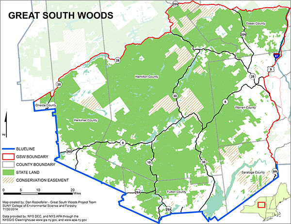
The map above depicts the Great South Woods planning area, which covers almost half the southern half of the Park.
One illustration of the potential for long-term damage is that while “natural resource protection” was an item on the surveys distributed at the end of the December 17th public information session, these words were never mentioned during the various introductions to the meeting or by any of the group facilitators. The key hazard for the GSW team is that natural resource protection will be given short shrift as the project seeks to build political support and expand into other phases or seeks additional resources.
Purpose of Project: The introductory materials to the GSWP state the goal is to “diversify and enhance outdoor recreation opportunities in the ‘Great South Woods’ – a vast area of public and private lands encompassing more than two million acres in the southern Adirondack Park.” When the State of New York cannot even complete unit management plans (UMPs) for some of the key units within the GSW, it is fair to question why the state is embarking on a more complicated process as basic foundational work has not yet been completed.
There are also other stated purposes of the GSW project. For its part, the Department of Environmental Conservation states it “has sponsored the Great South Woods initiative with the goal of creating a destination-based system of trails and recreation assets to stimulate economic activity while protecting the region’s unparalleled natural resources and wild character. ESF will facilitate the participatory process to engage local knowledge about how best to connect recreation destinations and communities through recreation infrastructure.”
Other statements said the GSW project was a “unique opportunity to integrate community planning with natural resource planning” and is a project “that can provide a model for a new era of collaborative planning that empowers communities while sustaining the wild character of the Adirondack Park.”
While PROTECT plans to monitor this project closely, we hope that the GSW project goes beyond the standard Adirondack maxim that if it doesn’t involve motors and cutting trees it’s not economic development.
The project is based on the supposed success of the “Five Towns Partnership,” a project of the Towns of North Hudson, Newcomb, Long Lake, Indian Lake and Minerva, which unfortunately to date has largely boiled down to community connections via new trails for motor vehicles that undermine long-term natural resource protection and the preservation of large intact forest systems. That’s not a model that should be replicated across the southern half of the Adirondack Park.
Many can embrace a project that seeks to integrate community planning with natural resource protection or empower communities while protecting natural resources. Yet, there is a great concern that this is an effort that will be used, irrespective of the framers good intentions, as a blueprint for a vast network of motorized recreation trails and to significantly scale back classified Wilderness lands.
Scope of Project: The GSW area is bigger than Rhode Island and Delaware. While this vast region is unified by a similar northern upland forested landscape, a vast public land complex, a sea of low elevation mountains and ranges, heavy summer tourism and recreation and limited winter recreation, and the APA Land Use and Development Plan, many of the communities are starkly dissimilar. The notions that Pottersville and Old Forge and Northville share similar aspirations or desire to be physically connected by recreation thoroughfares are unproven at best.
GSW Project Should Publish its Data: At the December 17th meeting, organizers stated that recreational opportunities are less in the GSW. What is this based on? Is this in comparison solely with the High Peaks Wilderness area? Does this include snowmobiling in the greater Old Forge area (and how did you count this?)? Downhill skiing at Gore Mountain? Whitewater rafting in the Hudson Gorge? Boating on the Great Sacandaga Reservoir? Hikers who climb Blue Mountain? The list goes on.
The data to support major organizing principles should be made public. In fact, as a rule of thumb, given that the GSW project is being financed with public funds, all data or supporting materials of any kind that have been organized to somehow guide the work of the GSW project should be made public. As it stands now, the December 17th meeting and the GSW website are largely data-free zones.
As mentioned above, recent major Adirondack Park planning projects have largely been undertaken behind closed doors through closed processes. The data and interworkings are available to a select few. The data that supposedly supports policy recommendations is not accessible or publicly available.
The GSW project should set a basic ground rule that it will be completely transparent and make everything available on an accessible website.
Forest Preserve Planning: There are 15 major Wild Forest, Wilderness and Primitive Forest Preserve units in the GSW. This does not include Intensive Use areas. The GSW area includes some of the best and worst of state Forest Preserve planning. More than 15 years after Governor George Pataki’s Unit Management Plan Initiative major Forest Preserve units throughout the GSW still do not have UMPs. These include the Wilcox Lake Wild Forest, Ferris Lake Wild Forest, and West Canada Lake Wilderness. These three units hold more than one-third of the total Forest Preserve within the GSW. These areas are joined by the new Essex Chain Lakes Primitive Area(s) and the Hudson Gorge Wilderness Area as Forest Preserve units without official, publicly vetted, approved plans.
10 of 15 units have approved UMPs. Of these eight are modern UMPs, including Moose River Plains Wild Forest, Blue Ridge Wilderness Area, Vanderwhacker Mountain Wild Forest, Hoffman Notch Wilderness Area, Silver Lake Wilderness, Shaker Mountain Wild Forest, Jessup River Wild Forest and the Siamese Ponds Wilderness. Two units have old, outdated and poorly organized UMPs – Black River Wild Forest area and the Blue Mountain Wild Forest.
It is fair to question the wisdom of a large and expensive regional planning process at a time when major Forest Preserve units do not have approved UMPs and others have inadequate and outdated UMPs.
Conservation Easement Lands Planning: The GSW area has poorly managed conservation easements in terms of planning for public access and providing an adequate infrastructure. None of these units has a final recreation plan and only one has a draft. Parts of these areas are used as vital links for snowmobile trails, but otherwise have not been developed or promoted for recreational opportunities. There are six major conservation easement tracts in the GSW, covering over 150,000 acres, yet these lands are largely locked away and off limits for widespread public use other than snowmobiling.
Value of Community Connectivity: We invite the framers of the GSW effort to think in terms of the connectivity of local communities to different natural amenities on nearby Forest Preserve and conservation easement lands rather than physical connections between communities through motor vehicle routes.
Many fear that community connectivity is a guise simply to crisscross the Forest Preserve with new motor vehicle roads. The recent major examples of community connections in the Adirondacks are the Wild Forest corridor for motor vehicles as part of the Essex Chain Lakes classifications and the controversial proposal to build a new multi-use trail through the interior of the Vanderwhacker Wild Forest area.
The GSW effort would provide a real service by detailing the abundance of opportunities for a range of outdoor recreational opportunities across its study area. The UMPs are a mixed bag for providing this information and do not think beyond standard list of parking areas, campsite and lean-to locations, trails to peaks or ponds, water access, and snowmobile trails that connect gas stations and bars.
If the full spectrum of Forest Preserve use opportunities were catalogued by the GSW effort that would constitute serious planning based on a platform of verified information. This should involve not just the standard array of features listed above, but also examine where new opportunities could be provided. The GSW area has challenging terrain for a serious hiker, such as the Little Great Range, where author Barbara McMartin long argued for a ridgetop trail, but also hundreds of areas that could be developed for the public that involves short excursions to beautiful places on what could be easy access trails, such as the Old Durant Road along Lake Durant or the taf’ oni rock formations at the base of Snowy Mountain, among many other such places.
There is great value in connecting communities to public lands in the Forest Preserve and conservation easements. There is far less value simply in blazing new trails through intact forests to physically connect communities. We can only hope that the GSW framers take a more expansive view of community connectivity than what we’ve seen thus far in other community planning efforts in the Adirondacks.
One such recent success to look at is the new trail up Moxham Mountain in Minerva. This trail was incredibly well planned out and designed and brings hikers along a 2.3-mile route to a variety of features and many different views. The trail deliberately passes through all the cool stuff that the area offers, such as beautiful forest stands, rock formations, streams, views from many ledges, among others. Contrast this trail with the staircase trails up Blue Mountain or Snowy or Wakely or Vanderwhacker Mountains where the only purpose or point of excitement is the summit. The Moxham Mountain trail sets a standard and it should be studied for replication by the GSW team.
Frontcountry-Backcountry Construct Does Not Apply to the Adirondack Park: In the Adirondack Park we have classified Wilderness areas that come down to roadsides. This is the case throughout the GSW area as nearly all major Wilderness areas are bordered at some point by a road. Frontcountry-backcountry is a planning construct that is poorly suited for application in the Adirondack Park, or other similar areas, where there is a checkerboard landscape of public and private lands and public land classifications.
Outside of the ecology of the immediate road-side edge communities we see very little difference in forest composition in the interior of an area such as the Blue Ridge Wilderness and areas that border the road, save for areas around ponds, wetlands or at higher elevations. And while there are certainly wildlife differences between interior and roadside habitats, adoption of frontcountry roadside classifications and management for more motorized trails systems will only push these roadside habitat influences further into the interior.
We’re looking for something to allay our fears the GSW project is not simply an effort to build political support to reduce the amount of classified Wilderness in the Adirondack Park through an imperfect and misapplied frontcountry-backcountry construct that does not recognize the vast ecological benefits that these Forest Preserve units have enjoyed for the highest level of natural resource protection that New York provides its Wilderness areas.
Great South Woods Maps: The quality of the maps provided to the public thus far as part of the GSW project have been a disappointment. While limitations of small 8.5×11″ handouts can be forgiven, the large format maps at the Speculator meeting were no better. Trail information was incomplete insofar as roads, hiking trails, snowmobile trails. This shows that the GSW team has not assembled adequate data about the existing public recreational infrastructure or trails, trailheads, parking areas. If you do not have a firm handle on this information, the larger more grandiose GSW plans will be crippled. A priority for the GSW effort needs to be the organization and mapping of the region’s public recreational infrastructure.
Notion that the Old Forge Snowmobiling Economy can be Replicated: If the Old Forge-Inlet winter economy could be widely replicated in the Adirondacks, then Indian Lake and Speculator would already be Old Forge 1 and 2. Inlet, which has long partnered with Old Forge, is the only other community that will benefit in a major way. There are a number of factors that make Old Forge unique in the Adirondack Park for winter sports, particularly snowmobiling. First, they have reliable snow. Other places in the Park do not. Second, Old Forge is connected with a longstanding trail system to another place with reliable snow – Tug Hill. This is not the case for other places in the Adirondacks, except places in between like Forestport. Third, the base of the Old Forge snowmobiling experience is a large private trail system that is municipally owned (largely acquired through the use of eminent domain) and outfitted with wide, well groomed trails. Other places do not have many scores of miles of trails on private lands. Fourth, because of the previous three factors, Old Forge has been promoting snowmobiling longer and better than other Adirondack community. Fifth, Old Forge has grown a winter tourism infrastructure while most other Adirondack communities are summer only. Businesses that can operate year-round provide a different local impact.
It’s simply not a viable economic development strategy to think that other Adirondack communities will build a snowmobiling economy anything like Old Forge-Inlet.
Long-term Climate Change Impacts and Threats: The GSW project should not operate within the same vacuum as the APA and DEC with regards to the impacts of climate change on the Adirondack Park. The GSW project should tackle this issue forthrightly and bring the best scientific modeling and serious risk assessment to your work. New York is making an enormous investment in snowmobiling as a major recreational and tourism development strategy for the Adirondacks. Yet, the snow season is declining as both the length of the season and total snow days are lessening. Yet, new snowmobile trails are being built, thousands of trees are being chopped down, and forever wild Forest Preserve lands are being excavated and graded with new trails.
This is a problem on many levels. First, Forest Preserve lands are being damaged for at best a short-term recreational activity. Second, we’re losing enormous opportunities to build long-term recreational opportunities by the major expenditures going to expand the snowmobile trail infrastructure. Third, an even greater long-term threat to the Forest Preserve is the inevitable call that snowmobile trails be converted to all-season All Terrain Vehicle (ATV) trail networks, which would be ruinous the Forest Preserve.
The GSW project team should do what the APA, DEC and other state agencies have refused to do and take a hard look at the long-term viability of snowmobiling and the wisdom of current financial investments given the reality of climate change and its local impacts in the Adirondacks.
Habitat Assessment: In addition to the recreational infrastructure the habitat of the GSW should be organized and mapped. This will be useful because this will help to expand recreational destinations. People like to hike to beautiful places. The GSW efforts should identify areas of old growth, wetlands, large beaver dams, scenic outcrops/ledges, small mountain peaks, and riverside walks, among many other opportunities.
Wildlife Planning: Absent in the public discussion and framing materials is any discussion about wildlife planning, protection, and building watchable wildlife programs. This should be a major organizing plank within the GSW scope. For example, within the GSW area are some of the Park’s highest moose concentration areas.
Making Parts of the Forest Preserve Easily Accessible: As mentioned above, one shortfall in Forest Preserve planning to date is the insufficient planning for public access to easily accessible beautiful areas, such as waterfalls, river rapids, beaver dams, wetlands, old growth forests, small peaks with big views, scenic points on lakes, among many many other landscape features that are close to roads. In the Adirondacks we have generally focused of building a recreational infrastructure of the more challenging terrains of the Park – High Peaks or near High Peaks – or building roads or snowmobile trails. We have not developed opportunities for short trips for the visitor that appreciates a wild landscape for its beauty but who has no interest in a difficult physically challenging hike or using an offroad motor vehicle.
Improving Forest Preserve Interpretation: In addition to expanding opportunities for short, easily accessible trails more needs to be done for public education and interpretation of the Park’s wild areas. If a series of interesting natural areas can be developed that can withstand public use, then accompanying this trail network with education and interpretation materials should be explored. This is one of the best ways to facilitate a sense of an Adirondack Park.
Roadside/Trailhead Signage: One longstanding problem has been the mishmash of signs, or lack of signs, that advertise hiking trails and trailhead parking. Those that are now used are generally ugly. We do not think that some new form of GSW logo/identification is needed (in fact once this planning process is over the GSW name should be buried and allowed to rot away deep in the West Canada Lakes Wilderness, never to be heard from again), but that this planning process should examine ways to dramatically improve Forest Preserve and conservation easement lands signs.
Terrestrial Invasive Species and Roads: Roads are the key vector for bringing terrestrial species and pests into the interior of the Forest Preserve. This has been seen in many Wild Forest area locations. Invasive species are also found along the illegal Crane Pond Road in the Pharaoh Lake Wilderness area. Intact Wilderness areas that do not allow motor vehicle use are the best protection for the Forest Preserve against invasive species. The GSW team needs to be mindful of the risks to forest systems from a network of new motor vehicle roads and trails or from implementing a front-country management construct on current Wilderness areas.
Lake Assets: The most valuable natural amenities in the GSW are the major lakes. These have long been the major destinations for the majority of visitors. While the GSW project is mostly focused on public lands, access to the major waters of the area and protection of these waters should not be overlooked, but should be central to GSW planning.
Focus on Intensive Use Areas: The GSW has some of the Adirondack Park’s best Intensive Use areas. These are parts of the Forest Preserve where the State of New York has made a major effort to build a robust tourism infrastructure. Moffit Beach, Lewey Lake, Limekiln Lake, Lake Durant, Moose River Plains, Nicks Lake, Northampton Beach – these areas all provide opportunities for tens of thousands of visitors each year. While many of these people return year after year, what is their relationship to the larger area? Part of the GSW effort should focus on an assessment of the use and impact of these areas to nearby communities
Fallacy of Multi-Use Trails: The greatest fallacy of Forest Preserve planners is the fiction of the multi-use trail. Hiking trails that go straight up a mountainside are not good mountainbiking trails or cross-country ski trails. Mountainbiking trails that run along contours and have various switchbacks are not good hiking or cross-country trails. Horse trails are lousy hiking trails. Hiking trails are not good horse trails. Roads are not good hiking trails. Snowmobile trails are not widely used for cross-country skiing. Snowmobile trails are not good hiking trails. The only successful multi-use trails are designated Forest Preserve roads that are not plowed in the winter and used for snowmobiling or oddities like the Santanoni Road where multiple uses are allowed, but constricted by regulations.
The GSW effort should recognize the reality of the fallacy of the multi-use trail. While the DEC, which is looking to conserve resources, places a great value on multi-use trails, there are very few successes of trails that are successfully used for multiple recreational activities. The GSW project should not buy into the same failed construct. Unfortunately, the DEC is unlikely, largely for political purposes, to relent in its efforts to designate and build road-like multi-use trails, and the APA will dutifully assent, but from a practical use standpoint these trails are failures and generate far fewer visits that single use trails built largely for a single recreational activity.
Organization of Natural Amenities and Destinations: One great service of the GSW project would be to organize and a catalogue the variety of outdoor recreational destinations across the GSW area. As mentioned at various points throughout this memo, this inventory should include an array of GSW natural amenities whether they have trails or not. The GSW project would provide long-term benefits if its analyzed the state of current trails, possible new trails, and a catalogue of natural amenities for public visitation.
Organization of Built Amenities and Destinations: In addition to natural amenities the GSW area has lots of amenities in the built environment. These range from restaurants and lodging facilities to firetowers and historic buildings. The GSW effort would also benefit from analyzing these facilities.
Summer and Winter Tourism Patterns: The GSW project should conduct an assessment of the tourism economies community by community for both summer and winter. Few communities have both. Most, but not all, have strong summer seasons. A few have strong winter seasons. Some have no meaningful winter or summer economy. There needs to be a basic assessment of what businesses would benefit from community connectivity in both winter and summer seasons.
Next Steps: Protect the Adirondacks will endeavor to monitor the GSW project as it moves ahead, as well as other related projects, and provide additional thoughts, observation and comments as this process unfolds.


